

Height Variation Depending on the Source of Antenna Phase Centre Corrections: LEIAR25.R3 Case Study
- PMID: 31533316
- PMCID: PMC6766827
- DOI: 10.3390/s19184010
Height Variation Depending on the Source of Antenna Phase Centre Corrections: LEIAR25.R3 Case Study
Abstract
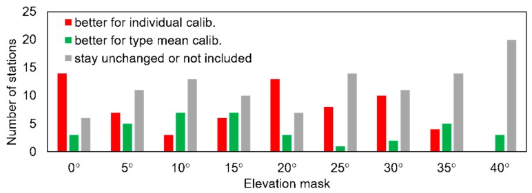
In this study, we compared two sets of antenna phase center corrections for groups of the same type of antenna mounted at the continuously operating global navigation satellite system (GNSS) reference stations. The first set involved type mean models provided by the International GNSS Service (release igs08), while the second set involved individual models developed by Geo++. Our goal was to check which set gave better results in the case of height estimation. The paper presents the differences between models and their impact on resulting height. Analyses showed that, in terms of the stability of the determined height, as well as its variability caused by increasing the facade mask, both models gave very similar results. Finally, we present a method for how to estimate the impact of differences in phase center corrections on height changes.
Keywords: GPS antenna; height estimates; minimum observation angle; phase center variations.
Conflict of interest statement
The authors declare no conflicts of interest.
Figures


References
-
- Chen H., Jiang W., Li J. Multi-GNSS Relative Positioning with Fixed Inter-System Ambiguity. Remote Sens. 2019;11:454. doi: 10.3390/rs11040454. - DOI
-
- Duong V., Harima K., Choy S., Laurichesse D., Rizos C. An optimal linear combination model to accelerate PPP convergence using multi-frequency multi-GNSS measurements. GPS Solut. 2019;23:49. doi: 10.1007/s10291-019-0842-2. - DOI
-
- Kiliszek D., Szolucha M., Kroszczynski K. Accuracy of Precise Point Positioning (PPP) with the use of different International GNSS Service (IGS) products and stochastic modelling. Geod. Cartogr. 2018;67:207–238. doi: 10.24425/gac.2018.125472. - DOI
-
- Prochniewicz D., Szpunar R., Walo J. A new study of describing the reliability of GNSS Network RTK positioning with the use of quality indicators. Meas. Sci. Technol. 2017;28:015012. doi: 10.1088/1361-6501/28/1/015012. - DOI
-
- Li B. Review of triple-frequency GNSS: Ambiguity resolution, benefits and challenges. J. Glob. Position. Syst. 2018;16 doi: 10.1186/s41445-018-0010-y. - DOI
Grants and funding
LinkOut - more resources
Full Text Sources
