

Contribution of low-cost sensor measurements to the prediction of PM2.5 levels: A case study in Imperial County, California, USA
- PMID: 31630004
- PMCID: PMC6899193
- DOI: 10.1016/j.envres.2019.108810
Contribution of low-cost sensor measurements to the prediction of PM2.5 levels: A case study in Imperial County, California, USA
Abstract
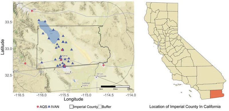
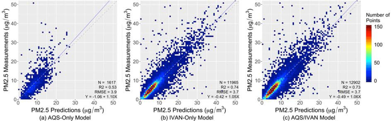
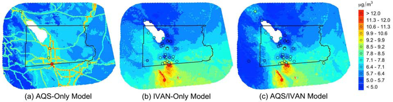
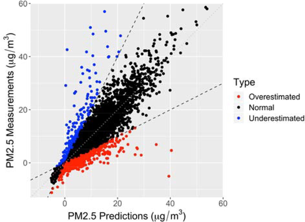
Regulatory monitoring networks are often too sparse to support community-scale PM2.5 exposure assessment while emerging low-cost sensors have the potential to fill in the gaps. To date, limited studies, if any, have been conducted to utilize low-cost sensor measurements to improve PM2.5 prediction with high spatiotemporal resolutions based on statistical models. Imperial County in California is an exemplary region with sparse Air Quality System (AQS) monitors and a community-operated low-cost network entitled Identifying Violations Affecting Neighborhoods (IVAN). This study aims to evaluate the contribution of IVAN measurements to the quality of PM2.5 prediction. We adopted the Random Forest algorithm to estimate daily PM2.5 concentrations at a 1-km spatial resolution using three different PM2.5 datasets (AQS-only, IVAN-only, and AQS/IVAN combined). The results show that the integration of low-cost sensor measurements is an effective way to significantly improve the quality of PM2.5 prediction with an increase of cross-validation (CV) R2 by ~0.2. The IVAN measurements also contributed to the increased importance of emission source-related covariates and more reasonable spatial patterns of PM2.5. The remaining uncertainty in the calibrated IVAN measurements could still cause apparent outliers in the prediction model, highlighting the need for more effective calibration or integration methods to relieve its negative impact.
Keywords: Low-cost sensor; Measurement uncertainty; Random forest; Satellite AOD.
Copyright © 2019 Elsevier Inc. All rights reserved.
Figures
Similar articles
-
Assessment and statistical modeling of the relationship between remotely sensed aerosol optical depth and PM2.5 in the eastern United States.Res Rep Health Eff Inst. 2012 May;(167):5-83; discussion 85-91. Res Rep Health Eff Inst. 2012. PMID: 22838153
-
Incorporating Low-Cost Sensor Measurements into High-Resolution PM2.5 Modeling at a Large Spatial Scale.Environ Sci Technol. 2020 Feb 18;54(4):2152-2162. doi: 10.1021/acs.est.9b06046. Epub 2020 Jan 27. Environ Sci Technol. 2020. PMID: 31927908
-
Development and field validation of a community-engaged particulate matter air quality monitoring network in Imperial, California, USA.J Air Waste Manag Assoc. 2017 Dec;67(12):1342-1352. doi: 10.1080/10962247.2017.1369471. Epub 2017 Aug 22. J Air Waste Manag Assoc. 2017. PMID: 28829718 Free PMC article.
-
Improving accuracy of air pollution exposure measurements: Statistical correction of a municipal low-cost airborne particulate matter sensor network.Environ Pollut. 2021 Jan 1;268(Pt B):115833. doi: 10.1016/j.envpol.2020.115833. Epub 2020 Oct 15. Environ Pollut. 2021. PMID: 33120139
-
Low-Cost Particulate Matter Mass Sensors: Review of the Status, Challenges, and Opportunities for Single-Instrument and Network Calibration.ACS Sens. 2025 May 23;10(5):3207-3221. doi: 10.1021/acssensors.4c03293. Epub 2025 May 7. ACS Sens. 2025. PMID: 40331533 Review.
Cited by
-
Socioeconomic Disparities of Low-Cost Air Quality Sensors in California, 2017-2020.Am J Public Health. 2022 Mar;112(3):434-442. doi: 10.2105/AJPH.2021.306603. Am J Public Health. 2022. PMID: 35196049 Free PMC article.
-
A Simple Optical Aerosol Sensing Method of Sauter Mean Diameter for Particulate Matter Monitoring.Biosensors (Basel). 2022 Jun 21;12(7):436. doi: 10.3390/bios12070436. Biosensors (Basel). 2022. PMID: 35884239 Free PMC article.
-
Examining PM2.5 concentrations and exposure using multiple models.Environ Res. 2021 May;196:110432. doi: 10.1016/j.envres.2020.110432. Epub 2020 Nov 7. Environ Res. 2021. PMID: 33166538 Free PMC article.
-
High-performance machine-learning-based calibration of low-cost nitrogen dioxide sensor using environmental parameter differentials and global data scaling.Sci Rep. 2024 Oct 30;14(1):26120. doi: 10.1038/s41598-024-77214-y. Sci Rep. 2024. PMID: 39478115 Free PMC article.
-
Investigating Use of Low-Cost Sensors to Increase Accuracy and Equity of Real-Time Air Quality Information.Environ Sci Technol. 2023 Jan 9:10.1021/acs.est.2c06626. doi: 10.1021/acs.est.2c06626. Online ahead of print. Environ Sci Technol. 2023. PMID: 36623253 Free PMC article.
References
-
- Blaylock BK, Horel JD, & Liston ST (2017). Cloud archiving and data mining of high-resolution rapid refresh forecast model output. Computers & Geosciences, 109, 43–50
-
- Bose S, Hansel N, Tonorezos E, Williams D, Bilderback A, Breysse P, Diette G, & McCormack MC (2015). Indoor particulate matter associated with systemic inflammation in COPD. Journal of Environmental Protection, 6, 566
-
- Breiman L (2001). Random forests. Machine Learning, 45, 5–32
Publication types
MeSH terms
Substances
Grants and funding
LinkOut - more resources
Full Text Sources
Medical
