

Soil & Water Assessment Tool (SWAT) simulated hydrological impacts of land use change from temperate grassland to energy crops: A case study in western UK
- PMID: 31762786
- PMCID: PMC6853257
- DOI: 10.1111/gcbb.12628
Soil & Water Assessment Tool (SWAT) simulated hydrological impacts of land use change from temperate grassland to energy crops: A case study in western UK
Abstract
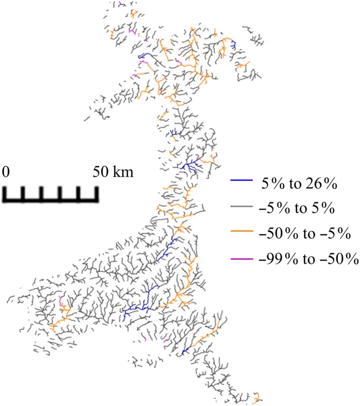
When considering the large-scale deployment of bioenergy crops, it is important to understand the implication for ecosystem hydrological processes and the influences of crop type and location. Based on the potential for future land use change (LUC), the 10,280 km2 West Wales Water Framework Directive River Basin District (UK) was selected as a typical grassland dominated district, and the Soil & Water Assessment Tool (SWAT) hydrology model with a geographic information systems interface was used to investigate implications for different bioenergy deployment scenarios. The study area was delineated into 855 sub-basins and 7,108 hydrological response units based on rivers, soil type, land use, and slope. Changes in hydrological components for two bioenergy crops (Miscanthus and short rotation coppice, SRC) planted on 50% (2,192 km2) or 25% (1,096 km2) of existing improved pasture are quantified. Across the study area as a whole, only surface run-off with SRC planted at the 50% level was significantly impacted, where it was reduced by up to 23% (during April). However, results varied spatially and a comparison of annual means for each sub-basin and scenario revealed surface run-off was significantly decreased and baseflow significantly increased (by a maximum of 40%) with both Miscanthus and SRC. Evapotranspiration was significantly increased with SRC (at both planting levels) and water yield was significantly reduced with SRC (at the 50% level) by up to 5%. Effects on streamflow were limited, varying between -5% and +5% change (compared to baseline) in the majority of sub-basins. The results suggest that for mesic temperate grasslands, adverse effects from the drying of soil and alterations to streamflow may not arise, and with surface run-off reduced and baseflow increased, there could, depending on crop location, be potential benefits for flood and erosion mitigation.
Keywords: Miscanthus; bioenergy; evapotranspiration; flooding; hydrology; short rotation coppice; streamflow.
© 2019 The Authors. GCB Bioenergy Published by John Wiley & Sons Ltd.
Figures


References
-
- Abbaspour, K. C. (2015). SWAT‐CUP: SWAT calibration and uncertainty programs—A user manual. Duebendorf, Switzerland: Department of Systems Analysis, Integrated Assessment and Modelling (SIAM), Eawag: Swiss Federal Institute of Aquatic Science and Technology; Retrieved from https://swat.tamu.edu/media/114860/usermanual_swatcup.pdf
-
- Abbaspour, K. C. , Rouholahnejad, E. , Vaghefi, S. , Srinivasan, R. , Yang, H. , & Kløve, B. (2015). A continental‐scale hydrology and water quality model for Europe: Calibration and uncertainty of a high‐resolution large‐scale SWAT model. Journal of Hydrology, 524, 733–752. 10.1016/j.jhydrol.2015.03.027 - DOI
-
- ADAS UK Ltd, & Energy Technologies Institute . (2016). Job implications of bioenergy. Retrieved from https://www.eti.co.uk/library/adas-relb-job-implications-of-establishing...
-
- Agriculture and Horticulture Development Board (AHDB) . (2018). Wheat growth guide. AHDB Cereals & Oilseeds, 1–44,https://cereals.ahdb.org.uk/media/185687/g66-wheat-growth-guide.pdf
-
- Alexander, P. , Moran, D. , Smith, P. , Hastings, A. , Wang, S. , Sünnenberg, G. , … Cisowska, I. (2014). Estimating UK perennial energy crop supply using farm‐scale models with spatially disaggregated data. Global Change Biology Bioenergy, 6(2), 142–155. 10.1111/gcbb.12121 - DOI
LinkOut - more resources
Full Text Sources
Miscellaneous