. 2019 Dec 9;6(1):283.
doi: 10.1038/s41597-019-0300-6.

Global hydro-environmental sub-basin and river reach characteristics at high spatial resolution

Affiliations

Global hydro-environmental sub-basin and river reach characteristics at high spatial resolution

Simon Linke et al. Sci Data. .

Abstract

The HydroATLAS database provides a standardized compendium of descriptive hydro-environmental information for all watersheds and rivers of the world at high spatial resolution. Version 1.0 of HydroATLAS offers data for 56 variables, partitioned into 281 individual attributes and organized in six categories: hydrology; physiography; climate; land cover & use; soils & geology; and anthropogenic influences. HydroATLAS derives the hydro-environmental characteristics by aggregating and reformatting original data from well-established global digital maps, and by accumulating them along the drainage network from headwaters to ocean outlets. The attributes are linked to hierarchically nested sub-basins at multiple scales, as well as to individual river reaches, both extracted from the global HydroSHEDS database at 15 arc-second (~500 m) resolution. The sub-basin and river reach information is offered in two companion datasets: BasinATLAS and RiverATLAS. The standardized format of HydroATLAS ensures easy applicability while the inherent topological information supports basic network functionality such as identifying up- and downstream connections. HydroATLAS is fully compatible with other products of the overarching HydroSHEDS project enabling versatile hydro-ecological assessments for a broad user community.


Conflict of interest statement

The authors declare no competing interests.

Figures

Fig. 1
Fig. 1
Conceptual design of HydroATLAS and relationship to underpinning HydroSHEDS database.
Fig. 2
Fig. 2
Example attributes of HydroATLAS. Top panel: land surface runoff per sub-basin of BasinATLAS (level 10 subdivisions). Bottom panel: natural discharge per river reach of RiverATLAS.
Fig. 3
Fig. 3
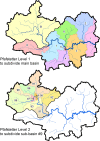
Overview of the Pfafstetter coding scheme used in the HydroBASINS dataset. At the first level (top panel), the original watershed is divided into nine sub-basins (i.e., into the four largest tributaries and the five resultant inter-basins). At the next level (bottom panel), each sub-basin is again divided into nine sub-basins. This process is iterated for each subsequent level of subdivisions.
Fig. 4
Fig. 4
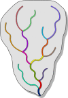
Overview of the river reach concept used in the HydroRIVERS dataset. Every river reach, depicted by a line segment in a different color, is defined as a stretch of river between two tributaries, or between the start/end of the network and a tributary.
Fig. 5
Fig. 5
Different spatial aggregation units used for the extraction of sub-basin and river reach attributes of HydroATLAS. Panel (a) shows the flow directions of every pixel from which the river network (red lines) and sub-basins are derived. Other panels show the spatial zones of: (b) sub-basins; (c) sub-basin pour points; (d) reach catchments; (e) river reaches; and (f) reach pour points. Individual zones are identified by different solid colors, while light background shades are for orientation only.

References

    1. Vörösmarty CJ, et al. Global threats to human water security and river biodiversity. Nature. 2010;467:555. doi: 10.1038/nature09440. - DOI - PubMed
    1. McIntyre PB, Liermann CAR, Revenga C. Linking freshwater fishery management to global food security and biodiversity conservation. Proc. Nat. Acad. Sci. 2016;113:12880–12885. doi: 10.1073/pnas.1521540113. - DOI - PMC - PubMed
    1. Dodds WK, Perkin JS, Gerken JE. Human impact on freshwater ecosystem services: a global perspective. Environ. Sci. Technol. 2013;47:9061–9068. doi: 10.1021/es4021052. - DOI - PubMed
    1. Green PA, et al. Freshwater ecosystem services supporting humans: pivoting from water crisis to water solutions. Global Environ. Change. 2015;34:108–118. doi: 10.1016/j.gloenvcha.2015.06.007. - DOI
    1. Dudgeon D, et al. Freshwater biodiversity: importance, threats, status and conservation challenges. Biol. Rev. 2006;81:163–182. doi: 10.1017/S1464793105006950. - DOI - PubMed

Publication types