

EGNOS 1046 Maritime Service Assessment
- PMID: 31947838
- PMCID: PMC6983232
- DOI: 10.3390/s20010276
EGNOS 1046 Maritime Service Assessment
Abstract
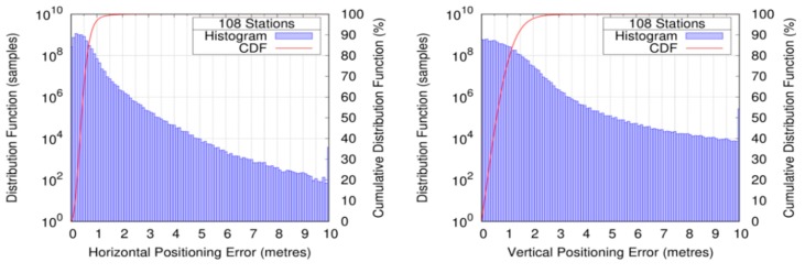
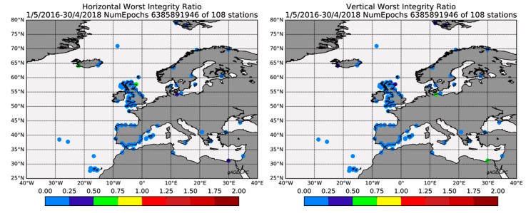
The present contribution evaluates how the European Geostationary Navigation Overlay System (EGNOS) meets the International Maritime Organization (IMO) requirements established in its Resolution A.1046 for navigation in harbor entrances, harbor approaches, and coastal waters: 99.8% of signal availability, 99.8% of service availability, 99.97% of service continuity and 10 m of horizontal accuracy. The data campaign comprises two years of data, from 1 May 2016 to 30 April 2018 (i.e., 730 days), involving 108 permanent stations located within 20 km of the coast or in islands across the EGNOS coverage area, EGNOS corrections, and cleansed GPS broadcast navigation data files. We used the GNSS Laboratory Tool Suite (gLAB) to compute the reference coordinates of the stations, the EGNOS solution, as well as the EGNOS service maps. Our results show a signal availability of 99.999%, a horizontal accuracy of 0.91 m at the 95th percentile, and the regions where the IMO requirements on service availability and service continuity are met. In light of the results presented in the paper, the authors suggest the revision of the assumptions made in the EGNOS Maritime Service against those made in EGNOS for civil aviation; in particular, the use of the EGNOS Message Type 10.
Keywords: Global Navigation Satellite System (GNSS); International Maritime Organization (IMO); Satellite Based Augmentation System (SBAS).
Conflict of interest statement
The authors declare no conflict of interest. The funders had no role in the design of the study; in the collection, analyses, or interpretation of data; in the writing of the manuscript; nor in the decision to publish the results.
Figures


References
-
- International Maritime Organization (IMO) International Convention for the Safety of Life at Sea (SOLAS) International Maritime Organization; London, UK: Nov 1, 1974. [(accessed on 2 January 2020)]. Available online: https://www.ifrc.org/docs/idrl/I456EN.pdf.
-
- International Maritime Organization Assembly . Resolution A.815(19) Worldwide Radionavigation System. International Maritime Organization Assembly; London, UK: Nov 23, 1995. [(accessed on 2 January 2020)]. Available online: http://www.imo.org/en/KnowledgeCentre/IndexofIMOResolutions/Assembly/Doc....
-
- International Maritime Organization Assembly (IMO) Resolution A.1046(27) Worldwide Radionavigation System. International Maritime Organization Assembly; London, UK: Nov 30, 2011. [(accessed on 2 January 2020)]. Available online: https://www.transportstyrelsen.se/contentassets/a498840125d6473e8046aec0....
-
- Yamada H. IMO and the GNSS (2017) Inside GNSS. Sep 19, 2017. [(accessed on 2 January 2020)]. Available online: https://insidegnss.com/imo-and-the-gnss/
-
- International Maritime Organization Maritime (IMO) Safety Committee . SN.1/Circ.329 Recognition of the Beidou satellite navigation system (BDS) as a component of the Worldwide Radionavigation System. International Maritime Organization Maritime Safety Committee; London, UK: Nov 21, 2014. [(accessed on 2 January 2020)]. Available online: https://www.transportstyrelsen.se/contentassets/a498840125d6473e8046aec0....
Grants and funding
LinkOut - more resources
Full Text Sources
Miscellaneous
