. 2020 Jan 28;10(1):1324.
doi: 10.1038/s41598-020-58284-0.

Estimating hospital catchments from in-patient admission records: a spatial statistical approach applied to malaria

Affiliations

Estimating hospital catchments from in-patient admission records: a spatial statistical approach applied to malaria

Victor A Alegana et al. Sci Rep. .

Abstract

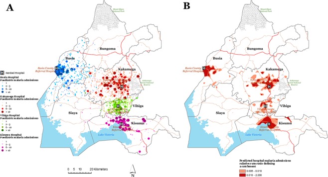
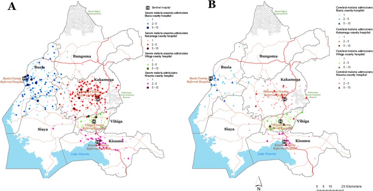
Admission records are seldom used in sub-Saharan Africa to delineate hospital catchments for the spatial description of hospitalised disease events. We set out to investigate spatial hospital accessibility for severe malarial anaemia (SMA) and cerebral malaria (CM). Malaria admissions for children between 1 month and 14 years old were identified from prospective clinical surveillance data recorded routinely at four referral hospitals covering two complete years between December 2015 to November 2016 and November 2017 to October 2018. These were linked to census enumeration areas (EAs) with an age-structured population. A novel mathematical-statistical framework that included EAs with zero observations was used to predict hospital catchment for malaria admissions adjusting for spatial distance. From 5766 malaria admissions, 5486 (95.14%) were linked to specific EA address, of which 272 (5%) were classified as cerebral malaria while 1001 (10%) were severe malaria anaemia. Further, results suggest a marked geographic catchment of malaria admission around the four sentinel hospitals although the extent varied. The relative rate-ratio of hospitalisation was highest at <1-hour travel time for SMA and CM although this was lower outside the predicted hospital catchments. Delineation of catchments is important for planning emergency care delivery and in the use of hospital data to define epidemiological disease burdens. Further hospital and community-based studies on treatment-seeking pathways to hospitals for severe disease would improve our understanding of catchments.


Conflict of interest statement

The authors declare no competing interests.

Figures

Figure 1
Figure 1
(A) Map showing the spatial distribution (counts) of all inpatient malaria admissions georeferenced to an EA address for children between 1 month and 14 years at the county referral hospital in western Kenya (Busia hospital n = 1140 admissions), Kakamega hospital (n = 1471 admissions), Vihiga hospital (n = 486 admissions) and Kisumu hospital (n = 1184 admissions). Data exclude severe malaria cases (SMA and CM cases). (B) The Bayesian predicted posterior median rate-ratio of hospital use (admission) for malaria defining a catchment by hospital adjusting for population, distance to the hospital. The prediction of catchment areas excluded CM and SMA cases.
Figure 2
Figure 2
Distribution of severe malaria anaemia (SMA) (n = 1001) and cerebral malaria (CM) (n = 272) admissions at the four sentinel hospitals.
Figure 3
Figure 3
Map showing the six counties (Busia, Kakamega, Vihiga, Kisumu, Siaya and Bungoma) and the four sentinel hospitals from which in-patient paediatric malaria admissions data was assembled. The four study hospitals were Busia county referral level-4 hospital with 185 beds, Kakamega provincial general level 5 hospital with 449 beds, Vihiga county level 4 hospital with 195 beds and the Vihiga county referral level 4 hospital with 160 beds. The red lines show main primary (trunk roads), secondary (minor trunk, single carriage roads) and tertiary roads (single carriage roads that connect truck roads) produced (via mapping) by the ministry of transport, infrastructure housing, urban development and public works. The small polygons within the county boundaries represent census Enumeration Areas (EAs, n = 7520) based on the 2009 housing census from the Kenya National Bureau of Statistics (KNBS). An EA is a small polygon (a village) estimated to contain 100 households during national household and population census for 2009.

Similar articles

Cited by

References

    1. World Health Organization. World Malaria Report 2018. (World Health organization, Geneva, 2018).
    1. Snow RW, et al. The prevalence of Plasmodium falciparum in sub-Saharan Africa since 1900. Nat. 2017;550:515. doi: 10.1038/nature24059. - DOI - PMC - PubMed
    1. Greenwood B, Marsh K, Snow R. Why do some African children develop severe malaria? Parasitol. Today. 1991;7:277–281. doi: 10.1016/0169-4758(91)90096-7. - DOI - PubMed
    1. Marsh K, et al. Indicators of life-threatening malaria in African children. N. Engl. J. Med. 1995;332:1399–1404. doi: 10.1056/NEJM199505253322102. - DOI - PubMed
    1. World Health Organization Severe Malaria. Tropical Med. Int. Health. 2014;19:7–131. doi: 10.1111/tmi.12313_2. - DOI - PubMed