

Daily activity locations k-anonymity for the evaluation of disclosure risk of individual GPS datasets
- PMID: 32138736
- PMCID: PMC7059321
- DOI: 10.1186/s12942-020-00201-9
Daily activity locations k-anonymity for the evaluation of disclosure risk of individual GPS datasets
Abstract
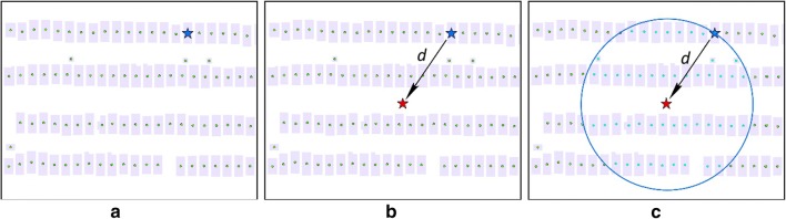
Background: Personal privacy is a significant concern in the era of big data. In the field of health geography, personal health data are collected with geographic location information which may increase disclosure risk and threaten personal geoprivacy. Geomasking is used to protect individuals' geoprivacy by masking the geographic location information, and spatial k-anonymity is widely used to measure the disclosure risk after geomasking is applied. With the emergence of individual GPS trajectory datasets that contains large volumes of confidential geospatial information, disclosure risk can no longer be comprehensively assessed by the spatial k-anonymity method.
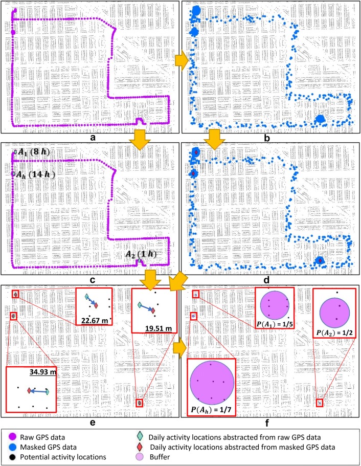
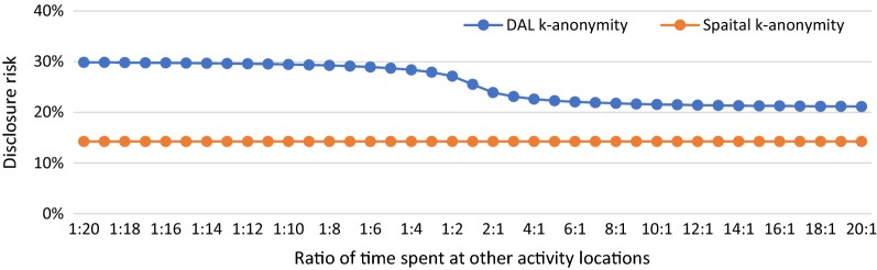
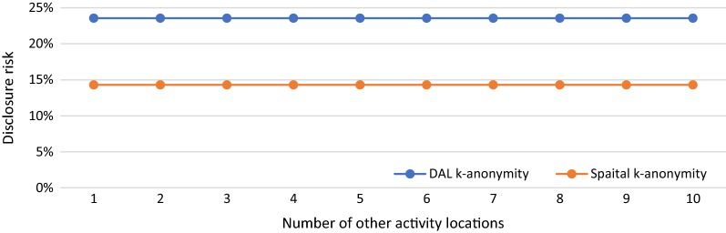
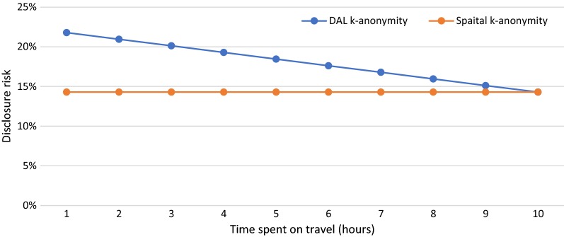
Methods: This study proposes and develops daily activity locations (DAL) k-anonymity as a new method for evaluating the disclosure risk of GPS data. Instead of calculating disclosure risk based on only one geographic location (e.g., home) of an individual, the new DAL k-anonymity is a composite evaluation of disclosure risk based on all activity locations of an individual and the time he/she spends at each location abstracted from GPS datasets. With a simulated individual GPS dataset, we present case studies of applying DAL k-anonymity in various scenarios to investigate its performance. The results of applying DAL k-anonymity are also compared with those obtained with spatial k-anonymity under these scenarios.
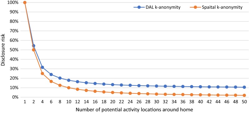
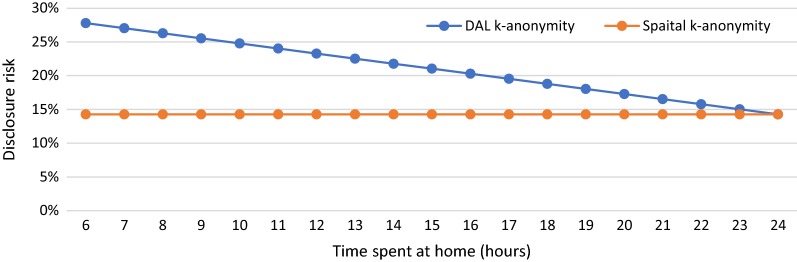
Results: The results of this study indicate that DAL k-anonymity provides a better estimation of the disclosure risk than does spatial k-anonymity. In various case-study scenarios of individual GPS data, DAL k-anonymity provides a more effective method for evaluating the disclosure risk by considering the probability of re-identifying an individual's home and all the other daily activity locations.
Conclusions: This new method provides a quantitative means for understanding the disclosure risk of sharing or publishing GPS data. It also helps shed new light on the development of new geomasking methods for GPS datasets. Ultimately, the findings of this study will help to protect individual geoprivacy while benefiting the research community by promoting and facilitating geospatial data sharing.
Keywords: Confidential geospatial data; GPS datasets; Geomasking; Geoprivacy; k-anonymity.
Conflict of interest statement
The authors declare that they have no competing interests.
Figures

Similar articles
-
Street masking: a network-based geographic mask for easily protecting geoprivacy.Int J Health Geogr. 2020 Jul 6;19(1):26. doi: 10.1186/s12942-020-00219-z. Int J Health Geogr. 2020. PMID: 32631351 Free PMC article.
-
Why does geoprivacy matter? The scientific publication of confidential data presented on maps.J Empir Res Hum Res Ethics. 2014 Oct;9(4):34-45. doi: 10.1177/1556264614544103. Epub 2014 Aug 11. J Empir Res Hum Res Ethics. 2014. PMID: 25747295
-
Exploring geomasking methods for geoprivacy: a pilot study in an environment with built features.Geospat Health. 2023 Oct 17;18(2). doi: 10.4081/gh.2023.1205. Geospat Health. 2023. PMID: 37847241
-
Ensuring Confidentiality of Geocoded Health Data: Assessing Geographic Masking Strategies for Individual-Level Data.Adv Med. 2014;2014:567049. doi: 10.1155/2014/567049. Epub 2014 Apr 29. Adv Med. 2014. PMID: 26556417 Free PMC article. Review.
-
Sharing traumatic stress research data: assessing and reducing the risk of re-identification.Eur J Psychotraumatol. 2025 Dec;16(1):2499296. doi: 10.1080/20008066.2025.2499296. Epub 2025 May 19. Eur J Psychotraumatol. 2025. PMID: 40387730 Free PMC article. Review.
Cited by
-
Opportunities and shortcomings of AI for spatial epidemiology and health disparities research on aging and the life course.Health Place. 2024 Sep;89:103323. doi: 10.1016/j.healthplace.2024.103323. Epub 2024 Jul 23. Health Place. 2024. PMID: 39047648 Free PMC article.
-
Home-to-school pedestrian mobility GPS data from a citizen science experiment in the Barcelona area.Sci Data. 2023 Jul 4;10(1):428. doi: 10.1038/s41597-023-02328-3. Sci Data. 2023. PMID: 37402776 Free PMC article.
-
LBS user location privacy protection scheme based on trajectory similarity.Sci Rep. 2022 Aug 17;12(1):13982. doi: 10.1038/s41598-022-18268-8. Sci Rep. 2022. PMID: 35978018 Free PMC article.
-
The utility of Zip4 codes in spatial epidemiological analysis.PLoS One. 2023 May 31;18(5):e0285552. doi: 10.1371/journal.pone.0285552. eCollection 2023. PLoS One. 2023. PMID: 37256874 Free PMC article.
-
Explorative pedestrian mobility geolocated data from a citizen science experiment in a neighbourhood.Sci Data. 2025 Jun 19;12(1):1036. doi: 10.1038/s41597-025-05307-y. Sci Data. 2025. PMID: 40537479 Free PMC article.
References
-
- Houston D. Implications of the modifiable areal unit problem for assessing built environment correlates of moderate and vigorous physical activity. Appl Geogr. 2014;50:40–47. doi: 10.1016/j.apgeog.2014.02.008. - DOI
Publication types
MeSH terms
LinkOut - more resources
Full Text Sources
