A modeling workflow that balances automation and human intervention to inform invasive plant management decisions at multiple spatial scales
- PMID: 32150554
- PMCID: PMC7062246
- DOI: 10.1371/journal.pone.0229253
A modeling workflow that balances automation and human intervention to inform invasive plant management decisions at multiple spatial scales
Abstract
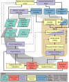
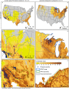
Predictions of habitat suitability for invasive plant species can guide risk assessments at regional and national scales and inform early detection and rapid-response strategies at local scales. We present a general approach to invasive species modeling and mapping that meets objectives at multiple scales. Our methodology is designed to balance trade-offs between developing highly customized models for few species versus fitting non-specific and generic models for numerous species. We developed a national library of environmental variables known to physiologically limit plant distributions and relied on human input based on natural history knowledge to further narrow the variable set for each species before developing habitat suitability models. To ensure efficiency, we used largely automated modeling approaches and human input only at key junctures. We explore and present uncertainty by using two alternative sources of background samples, including five statistical algorithms, and constructing model ensembles. We demonstrate the use and efficiency of the Software for Assisted Habitat Modeling [SAHM 2.1.2], a package in VisTrails, which performs the majority of the modeling analyses. Our workflow includes solicitation of expert feedback on model outputs such as spatial prediction results and variable response curves, and iterative improvement based on new data availability and directed field validation of initial model results. We highlight the utility of the models for decision-making at regional and local scales with case studies of two plant species that invade natural areas: fountain grass (Pennisetum setaceum) and goutweed (Aegopodium podagraria). By balancing model automation with human intervention, we can efficiently provide land managers with mapped predicted distributions for multiple invasive species to inform decisions across spatial scales.
Conflict of interest statement
The authors have declared that no competing interests exist.
Figures


References
-
- Thuiller W, Richardson DM, Pyšek P, Midgley GF, Hughes GO, Rouget M. Niche-based modelling as a tool for predicting the risk of alien plant invasions at a global scale. Global Change Biology. 2005;11(12):2234–50. - PubMed
-
- Li D, Lockwood JL, Baiser B. Taxonomic and Phylogenetic Homogenization Across US National Parks: The Role of Non-native Species In: Rozzi R, May RH Jr., Chapin FS III, Massardo F, Gavin MC, Klaver IJ, et al. , editors. From Biocultural Homogenization to Biocultural Conservation [Internet]. Cham: Springer International Publishing; 2018. [cited 2019 Sep 12]. p. 275–88. (Ecology and Ethics). 10.1007/978-3-319-99513-7_17 - DOI
-
- Simpson A, Jarnevich C, Madsen J, Westbrooks R, Fournier C, Mehrhoff L, et al. Invasive species information networks: collaboration at multiple scales for prevention, early detection, and rapid response to invasive alien species. Biodiversity. 2009. September 1;10(2–3):5–13.
Publication types
MeSH terms
LinkOut - more resources
Full Text Sources

