. 2020 Mar 18;15(3):e0229826.
doi: 10.1371/journal.pone.0229826. eCollection 2020.

Crater detection from commercial satellite imagery to estimate unexploded ordnance in Cambodian agricultural land

Affiliations

Crater detection from commercial satellite imagery to estimate unexploded ordnance in Cambodian agricultural land

Erin Lin et al. PLoS One. .

Abstract

Unexploded ordnance (UXO) pose a significant threat to post-conflict communities, and current efforts to locate bombs rely on time-intensive and dangerous in-person enumeration. Very high resolution (VHR) sub-meter satellite images may offer a low-cost and high-efficiency approach to automatically detect craters and estimate UXO density. Machine-learning methods from the meteor crater literature are ill-suited to find bomb craters, which are smaller than meteor craters and have high appearance variation, particularly in spectral reflectance and shape, due to the complex terrain environment. A two-stage learning-based framework is created to address these challenges. First, a simple and loose statistical classifier based on histogram of oriented gradient (HOG) and spectral information is used for a first pass of crater recognition. In a second stage, a patch-dependent novel spatial feature is developed through dynamic mean-shift segmentation and SIFT descriptors. We apply the model to a multispectral WorldView-2 image of a Cambodian village, which was heavily bombed during the Vietnam War. The proposed method increased true bomb crater detection by over 160 percent. Comparative analysis demonstrates that our method significantly outperforms typical object-recognition algorithms and can be used for wide-area bomb crater detection. Our model, combined with declassified records and demining reports, suggests that 44 to 50 percent of the bombs in the vicinity of this particular Cambodian village may remain unexploded.


Conflict of interest statement

The authors have declared that no competing interests exist.

Figures

Fig 1
Fig 1. Photographs of (a) a bomb crater in Cambodia [author’s image] and (b) meteor craters on moon [from NASA’s Earth Observatory Database [21]].
Meteor craters tend to be more precisely circular and do not experience erosion, suggesting that bomb craters require an alternative method of detection.
Fig 2
Fig 2. The Very High Resolution (VHR) satellite image is located in Prey Veng province, Cambodia, part of a heavily bombed area roughly 30 kilometers from the Vietnam border.
Each gray dot represents one of 113,716 payloads dropped over Cambodia from 1965 to 1973. Basemap from USGS National Boundaries Dataset (URL: https://viewer.nationalmap.gov/advanced-viewer/).
Fig 3
Fig 3. The satellite image (100 km2) of the study site.
After we built and evaluated the two-stage model on the training and validation region, detection was performed over the entire region.
Fig 4
Fig 4. Example patches of correctly identified bomb craters (a) and falsely identified bomb craters (b).
The selection of false bomb crater images include a building, pond, and trees from the first stage classification.
Fig 5
Fig 5. Workflow of the two-stage framework for bomb crater detection.
Fig 6
Fig 6. A diagram of the algorithm for our adaptive mean-shift (MS) segmentation (a) and an illustrative example of the adaptive MS segmentation process (b).
An image of a real bomb crater is segmented in the top row, and an image of a building (a false positive) is segmented in the bottom row. Column i shows the original patches. Column ii, iii, and iv show the segmented results with a range radius of 5, 4, and 3 pixels respectively. The range bandwidth is reduced progressively until the central segment appears as specified.
Fig 7
Fig 7. A visual example of the critical shape parameters that define the AMSBS feature.
The original image of a crater (a) is measured to obtain the minimum and maximum distance from patch center to the segment boundaries, dmin and dmax (b), in addition to maximum compactness rmax (c).
Fig 8
Fig 8. Detection results over the entire WorldView image.
Eighty-three percent of the crater candidates from the first stage were dropped after the second stage refinement.
Fig 9
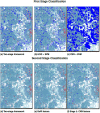
Fig 9. Results of candidate detection (first stage) and crater refinement (second stage), comparing our two-stage framework to widely-used alternatives.
A red box indicates the model correctly found a bomb crater. A blue box indicates the model found a false positive.
Fig 10
Fig 10. Payload drop zone for the US airstrikes over the satellite image during the Vietnam War.
Over 98 percent of detected craters fall within 1,750 meters from a payload drop coordinates. These craters are highlighted in blue while craters outside the target buffers are represented in red.
Fig 11
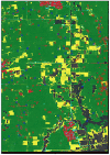
Fig 11. Land classification for the satellite image.
Land cover classification suggests that the majority of the land surrounding Kampong Trabaek is actively cultivated, despite likely UXO contamination. The gray squares represent detected craters.
Fig 12
Fig 12. Land classification within the validation region.
A close-up of the validation region shows that the two-stage framework has reliable accuracy across cultivated, uncultivated, and developed land. The red squares are false positives and the blue squares are true positives.

References

    1. UNICEF. Landmines post gravest risk for children. 2004;.
    1. Darwish R, Farajalla N, Masri R. The 2006 war and its inter-temporal economic impact on agriculture in Lebanon. Disasters. 2009;33(4):629–644. 10.1111/j.1467-7717.2008.01091.x - DOI - PubMed
    1. McGrath R. Landmines and unexploded ordnance: a resource book. Pluto Press; 2000.
    1. Collier P, Elliot VL, Hegre H, Hoeffler A, Reynal-Querol M, Sambanis N. Breaking the conflict trap: Civil war and development policy. World Bank; 2003.
    1. Webster D. Aftermath: The remnants of war. Vintage; 1998.

Publication types