

Development of a Spatial Decision Support System for Real-Time Flood Early Warning in the Vu Gia-Thu Bon River Basin, Quang Nam Province, Vietnam
- PMID: 32192135
- PMCID: PMC7147717
- DOI: 10.3390/s20061667
Development of a Spatial Decision Support System for Real-Time Flood Early Warning in the Vu Gia-Thu Bon River Basin, Quang Nam Province, Vietnam
Abstract
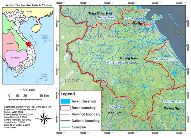
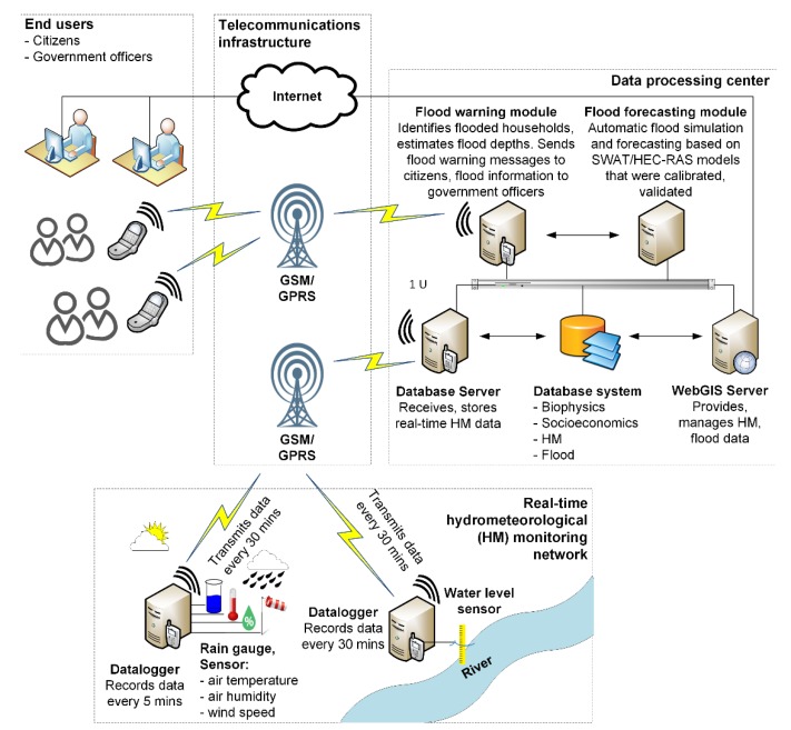
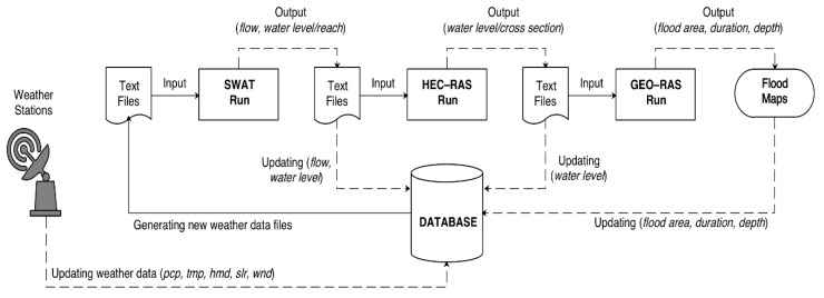
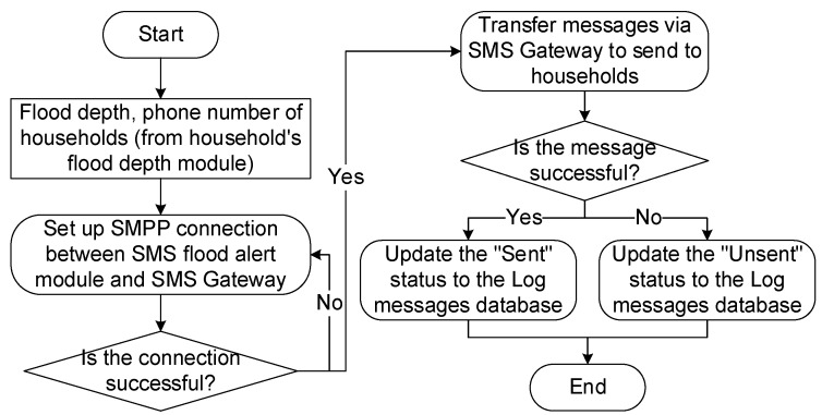
Vu Gia-Thu Bon (VGTB) river basin is an area where flash flood and heavy flood events occur frequently, negatively impacting the local community and socio-economic development of Quang Nam Province. In recent years, structural and non-structural solutions have been implemented to mitigate damages due to floods. However, under the impact of climate change, natural disasters continue to happen unpredictably day by day. It is, therefore, necessary to develop a spatial decision support system for real-time flood warnings in the VGTB river basin, which will support in ensuring the area's socio-economic development. The main purpose of this study is to develop an online flood warning system in real-time based on Internet-of-Things (IoT) technologies, GIS, telecommunications, and modeling (Soil and Water Assessment Tool (SWAT) and Hydrologic Engineering Center's River Analysis System (HEC-RAS)) in order to support the local community in the vulnerable downstream areas in the event of heavy rainfall upstream. The structure of the designed system consists of these following components: (1) real-time hydro-meteorological monitoring network, (2) IoT communication infrastructure (Global System for Mobile Communications (GSM), General Packet Radio Service (GPRS), wireless networks), (3) database management system (bio-physical, socio-economic, hydro-meteorological, and inundation), (4) simulating and predicting model (SWAT, HEC-RAS), (5) automated simulating and predicting module, (6) flood warning module via short message service (SMS), (7) WebGIS, application for providing and managing hydro-meteorological and inundation data, and (8) users (citizens and government officers). The entire operating processes of the flood warning system (i.e., hydro-meteorological data collecting, transferring, updating, processing, running SWAT and HEC-RAS, visualizing) are automated. A complete flood warning system for the VGTB river basin has been developed as an outcome of this study, which enables the prediction of flood events 5 h in advance and with high accuracy of 80%.
Keywords: HEC–RAS; SWAT; automated flood warning system; decision support system; flood forecasting.
Conflict of interest statement
The authors declare no conflict of interest.
Figures


Similar articles
-
Spatial appraisal of flood risk assessment and evaluation using integrated hydro-probabilistic approach in Panjkora River Basin, Pakistan.Environ Monit Assess. 2019 Aug 17;191(9):573. doi: 10.1007/s10661-019-7746-z. Environ Monit Assess. 2019. PMID: 31420751
-
Combined top-down and bottom-up climate change impact assessment for the hydrological system in the Vu Gia- Thu Bon River Basin.Sci Total Environ. 2018 Jul 15;630:718-727. doi: 10.1016/j.scitotenv.2018.02.250. Epub 2018 Feb 27. Sci Total Environ. 2018. PMID: 29494979
-
Flood hazard delineation in an ungauged catchment by coupling hydrologic and hydraulic models with geospatial techniques-a case study of Koraiyar basin, Tiruchirappalli City, Tamil Nadu, India.Environ Monit Assess. 2020 Oct 8;192(11):689. doi: 10.1007/s10661-020-08650-2. Environ Monit Assess. 2020. PMID: 33030599
-
Identifying hydro-meteorological events from precipitation extremes indices and other sources over northern Namibia, Cuvelai Basin.Jamba. 2015 Oct 30;7(1):177. doi: 10.4102/jamba.v7i1.177. eCollection 2015. Jamba. 2015. PMID: 29955280 Free PMC article. Review.
-
Improving flood and drought management in transboundary Upper Jhelum Basin-South Asia.Sci Total Environ. 2024 Oct 1;945:174044. doi: 10.1016/j.scitotenv.2024.174044. Epub 2024 Jun 16. Sci Total Environ. 2024. PMID: 38889820 Review.
Cited by
-
Starter Kit for Geotagging and Geovisualization in Health Care: Resource Paper.JMIR Form Res. 2020 Dec 24;4(12):e23379. doi: 10.2196/23379. JMIR Form Res. 2020. PMID: 33361054 Free PMC article.
-
An assessment of uncontrolled human interventions on the contemporary sediment budget and morphological alterations of the Vu Gia Thu Bon River basin, central Vietnam.Heliyon. 2024 May 28;10(11):e31476. doi: 10.1016/j.heliyon.2024.e31476. eCollection 2024 Jun 15. Heliyon. 2024. PMID: 38868035 Free PMC article.
-
The Application of SWAT Model and Remotely Sensed Products to Characterize the Dynamic of Streamflow and Snow in a Mountainous Watershed in the High Atlas.Sensors (Basel). 2023 Jan 21;23(3):1246. doi: 10.3390/s23031246. Sensors (Basel). 2023. PMID: 36772286 Free PMC article.
-
Leveraging artificial intelligence in disaster management: A comprehensive bibliometric review.Jamba. 2025 Apr 7;17(1):1776. doi: 10.4102/jamba.v17i1.1776. eCollection 2025. Jamba. 2025. PMID: 40357012 Free PMC article.
References
-
- Kreft S., Eckstein D., Melchior I. Global Climate Risk Index 2017: Who Suffers Most from Extreme Weather Events? Weather-Related Loss Events in 2015 and 1996 to 2015. Germanwatch; Bonn, Germany: 2016.
-
- Tri O.D.B. Ph.D. Thesis. Lincoln University; Lincoln, PA, USA: 2017. A Spatial Decision Support System for Flood Hazard in Quang Nam Province, Vietnam.
-
- World Bank . Economics of Adaptation to Climate Change: Vietnam. World Bank; Washington, DC, USA: 2010.
-
- Ranger N., Lopez A. The Role of Climate Change in Urban Flood Risk Management Today. Grantham Research Institute on Climate Change and the Environment, Centre for Climate Change Economics and Policy; London, UK: 2011.
-
- Shaw S.B., Riha S.J. Assessing possible changes in flood frequency due to climate change in mid-sized watersheds in New York State, USA. Hydrol. Process. 2011;25:2542–2550. doi: 10.1002/hyp.8027. - DOI
Grants and funding
LinkOut - more resources
Full Text Sources
