. 2020 Mar 23;15(3):e0230264.
doi: 10.1371/journal.pone.0230264. eCollection 2020.

Migrant mobility flows characterized with digital data

Affiliations

Migrant mobility flows characterized with digital data

Mattia Mazzoli et al. PLoS One. .

Abstract

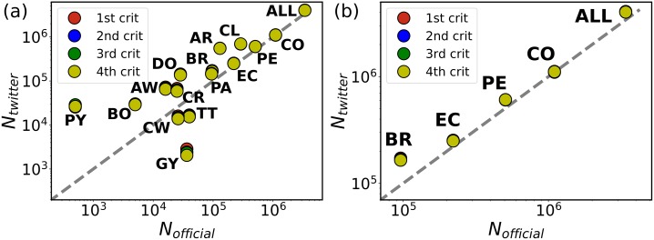
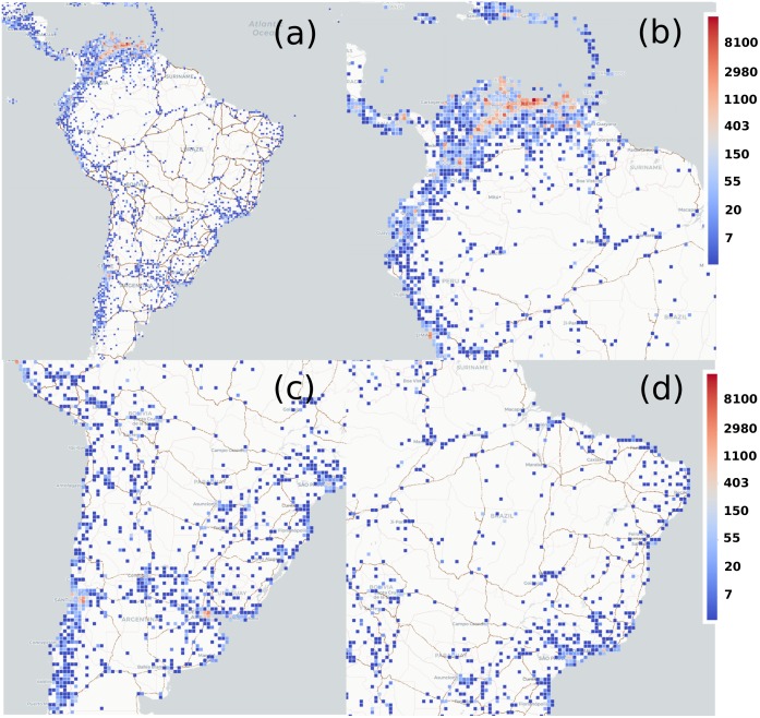
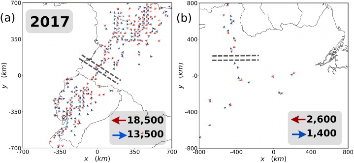
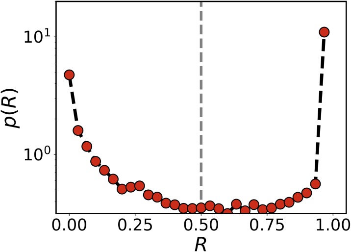
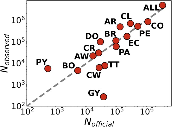
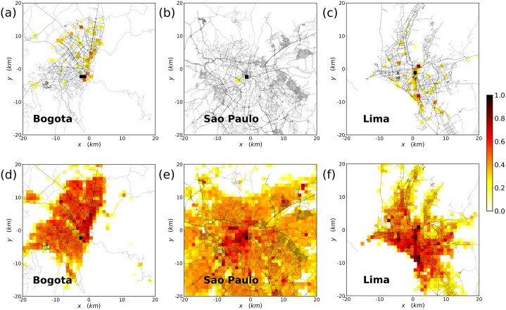
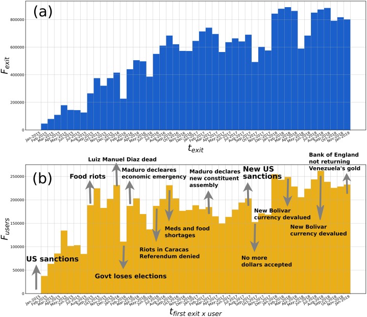
Monitoring migration flows is crucial to respond to humanitarian crisis and to design efficient policies. This information usually comes from surveys and border controls, but timely accessibility and methodological concerns reduce its usefulness. Here, we propose a method to detect migration flows worldwide using geolocated Twitter data. We focus on the migration crisis in Venezuela and show that the calculated flows are consistent with official statistics at country level. Our method is versatile and far-reaching, as it can be used to study different features of migration as preferred routes, settlement areas, mobility through several countries, spatial integration in cities, etc. It provides finer geographical and temporal resolutions, allowing the exploration of issues not contemplated in official records. It is our hope that these new sources of information can complement official ones, helping authorities and humanitarian organizations to better assess when and where to intervene on the ground.


Conflict of interest statement

The authors have declared that no competing interests exist.

Figures

Fig 1
Fig 1. Country-level flow validation.
Comparison between the migrant flows estimated from the upscaled Twitter data Ntwitter following the different resident criteria and the official numbers Nofficial from the UNHCR in January 2018. These official numbers in some countries are projections. Each point corresponds to a country. The panel (a) shows all the countries of the considered area, and the panel (b) specific detail for neighboring countries from which a humanitarian crisis has been reported. In both cases, the grey dashed lines are the diagonal. The correlation produces a R2 = 0.98 for all the countries and R2 = 0.99 for Brazil, Colombia, Ecuador and Peru alone. The country codes are Argentina (AR), Aruba (AW), Bolivia (BO), Brazil (BR), Chile (CL), Colombia (CO), Costa Rica (CR), Curaçao (CW), Dominican Republic (DO), Ecuador (EC), Guyana (GY), Panama (PA), Paraguay (PY), Peru (PE) and Trinidad and Tobago (TT). The panels are displayed in log-log scale due to the several orders of magnitude of the flows. However, the important point here is to verify the identity between expected and measured values and, therefore, the correlation analysis is performed with R2 in the original scale.
Fig 2
Fig 2. Migrants’ routes.
Number of individuals observed in every 40 × 40 km2 cell in the area of study. The heatmap scale is logarithmic. Only cells with more than 3 individuals are displayed. In (a) the full South American continent plus the Caribbean and Center America; (b) A zoom in on the Northern area focused on the Caribbean; In (c), a zoom in highlighting the Southern Cone; And in (d), a zoom in on Brazil. Map tiles by Carto, under CC-BY 4.0. Data by OpenStreetMap, underODbL.
Fig 3
Fig 3. Crossing routes.
Map of two main ground migrant exit routes from Venezuela reported by official agencies: in (a) the Pan-American road with a portion of Colombia, Ecuador and Peru, and in (b) the area of Roraima, Amazonas and Pará states in Brazil. Blue arrows indicate flows toward Venezuela and the red ones away from it. Only cells with more than three TUVs are shown in the maps. The lightness of the color of the arrows is proportional to the net in- and out-flows from light to darker colors. The upscaled net flows crossing the dashed lines are displayed in the right-bottom corner of each plot.
Fig 4
Fig 4. Time spent abroad.
Probability distribution of the fraction of time spent abroad after the first country exit. TUVs with R lower than 0.5 are classified as recurrent.
Fig 5
Fig 5. Validation of new residents.
Scattered plot with the comparison between the estimations of new Venezuelan residents obtained with our method and the official data from the international agencies in each country. Every circle is a country, the dashed gray line is the diagonal. In this case, the correlation is R2 = 0.97. The plot is displayed in log-log scale due to the several orders of magnitude of the number of residents. As before, the important point is to verify the identity and, therefore, the correlation analysis is performed in the linear scale.
Fig 6
Fig 6. Residence locations in the main cities.
Log-scale heat map of the population distribution in the main cities of the area. In the top row, the data corresponds to numbers of migrant TUVs and in the bottom to the local geolocated Twitter users. The scale of the heatmap is logarithmic and the maximum is rescaled in each of the maps. In (a) and (d), results for Bogotá (Colombia). In (b) and (e) for São Paulo (Brazil. And, in (c) and (f), for Lima (Peru). Data on roads by OpenStreetMap contributors and from MapCruzin, all available under the Open Database License ODbL. For more information check [56].
Fig 7
Fig 7. Exit times distribution.
(a) Total upscaled exits from Venezuela Fexit. (b) First exits from Venezuela per TUV upscaled to obtain Fusers.

References

    1. Jones D. Conflict resolution: Wars without end. Nature. 2015;519:148 10.1038/519148a - DOI - PubMed
    1. López-Carr D, Marter-Kenyon J. Human adaptation: Manage climate-induced resettlement. Nature. 2015;517:265 10.1038/517265a - DOI - PubMed
    1. Ravenstein EG. The laws of migration. Journal of the Statistical Society of London. 1885;48:167–235. 10.2307/2979181 - DOI
    1. Abel GJ, Sander N. Quantifying global international migration flows. Science. 2014;343:1520–1522. 10.1126/science.1248676 - DOI - PubMed
    1. Rogers A, Willekens F, Ledent J. Migration and settlement: a multiregional comparative study. Environment and planning A. 1983;15:1585–1612. 10.1068/a151585 - DOI - PubMed

Publication types

MeSH terms