

Monitoring Aircraft Position Using EGNOS Data for the SBAS APV Approach to the Landing Procedure
- PMID: 32235680
- PMCID: PMC7181284
- DOI: 10.3390/s20071945
Monitoring Aircraft Position Using EGNOS Data for the SBAS APV Approach to the Landing Procedure
Abstract
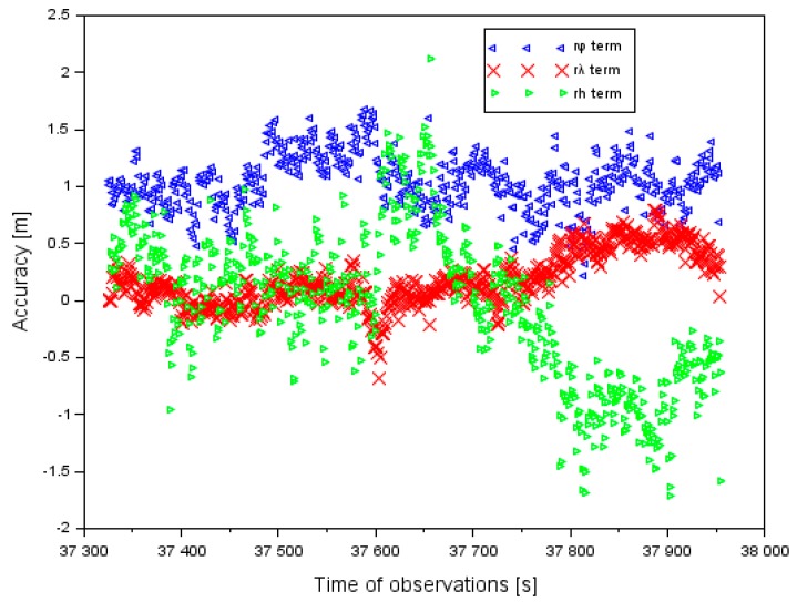
The aim of this paper is to present the problem of the implementation of the EGNOS (European Geostationary Navigation Overlay Service) data for the processing of aircraft position determination. The main aim of the research is to develop a new computational strategy which might improve the performance of the EGNOS system in aviation, based on navigation solutions of an aircraft position, using several GNSS (Global Navigation Satellite System) onboard receivers. The results of an experimental test conducted by the Cessna 172 at EPDE (European Poland Deblin) (ICAO (International Civil Aviation Organization) code, N51°33.07'/E21°53.52') aerodrome in Dęblin are presented and discussed in this paper. Two GNSS navigation receivers with the EGNOS positioning function for monitoring changes in the parameters of the aircraft position in real time during the landing phase were installed onboard a Cessna 172. Based on obtained research findings, it was discovered that the positioning accuracy was not higher than 2.1 m, and the integrity of positioning did not exceed 19 m. Moreover, the availability parameter was found to equal 1 (or 100%); also, no intervals in the continuity of the operation of the EGNOS system were recorded. In the paper, the results of the air test from Dęblin were compared with the parameters of positioning quality from the air test conducted in Chełm (ICAO code: EPCD, N51°04'57.8" E23°26'15"). In the air test in Chełm, the obtained parameters of EGNOS quality positioning were: better than 4.9 m for accuracy, less than 35.5 m for integrity, 100% for availability, and no breaks in continuity. Based on the results of the air tests in Dęblin and Chełm, it was concluded that the parameters of the EGNOS positioning quality in aviation for the SBAS (Satellite Based Augmentation System) APV (Approach to Vertical guidance) procedure were satisfied in accordance with the ICAO (International Civil Aviation Organization) requirements. The presented research method can be utilized in the SBAS APV landing procedure in Polish aviation. In this paper, the results of PDOP (Position Dilution of Precision) are presented and compared to the two air tests in Dęblin and Chełm. The maximum results of PDOP amounted to 1.4 in the air test in Dęblin, whereas they equaled 4.0 in the air test in Chełm. The paper also shows how the EGNOS system improved the aircraft position in relation to the only GPS solution. In this context, the EGNOS system improved the aircraft position from about 78% to 95% for each ellipsoidal coordinate axis.
Keywords: EGNOS; SBAS APV; accuracy; availability; continuity; integrity.
Conflict of interest statement
The authors declare no conflict of interest.
Figures


References
-
- Fellner A., Banaszek K., Trómiński P. The implementation of the EGNOS system to APV-I precision approach operations. Trans. Nav. Int. J. Mar. Navig. Safe. Sea Transp. 2010;4:41–46.
-
- Kaleta W. EGNOS Based APV Procedures Development Possibilities In The South-Eastern Part Of Poland. Ann. Navig. 2014;21:85–94. doi: 10.1515/aon-2015-0007. - DOI
-
- International Civil Aviation Organization ICAO Standards and Recommended Practices (SARPS), Annex 10 Volume I (Radio Navigation Aids) [(accessed on 30 March 2020)];2006 Available online: www.ulc.gov.pl/pl/prawo/prawo-mi%C4%99dzynarodowe/206-konwencje.
-
- Grzegorzewski M. Navigating an aircraft by means of a position potential in three dimensional space. Ann. Navig. 2005;9:111.
-
- Ciećko A., Grzegorzewski M., Ćwiklak J., Oszczak S., Jafernik H. Proceeding of the Aviation Technology, Integration, and Operations Conference (ATIO 2013), Los Angeles, CA, USA, 12–14 August 2013. Volume 1. Red Hook; Curran, NY, USA: 2013. Air navigation in eastern Poland based on EGNOS; pp. 603–613.
LinkOut - more resources
Full Text Sources
