. 2020 Apr 14;11(1):1826.
doi: 10.1038/s41467-020-15579-0.

Sediment controls dynamic behavior of a Cordilleran Ice Stream at the Last Glacial Maximum

Affiliations

Sediment controls dynamic behavior of a Cordilleran Ice Stream at the Last Glacial Maximum

Ellen A Cowan et al. Nat Commun. .

Abstract

The uncertain response of marine terminating outlet glaciers to climate change at time scales beyond short-term observation limits models of future sea level rise. At temperate tidewater margins, abundant subglacial meltwater forms morainal banks (marine shoals) or ice-contact deltas that reduce water depth, stabilizing grounding lines and slowing or reversing glacial retreat. Here we present a radiocarbon-dated record from Integrated Ocean Drilling Program (IODP) Site U1421 that tracks the terminus of the largest Alaskan Cordilleran Ice Sheet outlet glacier during Last Glacial Maximum climate transitions. Sedimentation rates, ice-rafted debris, and microfossil and biogeochemical proxies, show repeated abrupt collapses and slow advances typical of the tidewater glacier cycle observed in modern systems. When global sea level rise exceeded the local rate of bank building, the cycle of readvances stopped leading to irreversible retreat. These results support theory that suggests sediment dynamics can control tidewater terminus position on an open shelf under temperate conditions delaying climate-driven retreat.


Conflict of interest statement

The authors declare no competing interests.

Figures

Fig. 1
Fig. 1. Study area.
Bathymetric map showing the shelf-crossing Bering Trough in southern Alaska. IODP Site U1421 is located on the continental slope, U1420 within the trough, and EW0408-85JC to the west. The modern extent of Bering Glacier is shown on the Landsat image, the estimated maximum Global LGM extent is shown by the blue line. The location of seismic profiles GOA2505 and USGS TT74 Line 20 in Fig. 3 is shown. Start of line GOA2505 in Fig. 3 is indicated by white triangle. Location of MD02-2496 shown by star in inset. This map was created using resources available through Esri, DigitalGlobe, GeoEye, Earthstar Geographics, CNES/Airbus DS, USDA, USGS, AeroGRID, IGN, and the GIS User Community.
Fig. 2
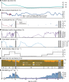
Fig. 2. Multiproxy records from slope Site U1421 from 27 to 15 kyr ago.
a Global mean sea level curve (m). b Regional sea surface temperature proxies from EW0408-85JC and MD02-2496 (Fig. 1). Mg/Ca values plotted using 4-pt moving average. c Values for δ18O analysis of N. pachyderma (sin.) in samples from site U1421 and survey site EW0408-85JC. Error bars (±1 sigma) are smaller than symbol size. d Percentage of benthic foraminifera indicative of meltwater. e Diatom valves per gram sediment. f Mean sedimentation rates (m kyr−1) binned at 1000-year intervals. One-sigma error is denoted by the dashed lines. g Distribution of grain sizes and lithofacies (I–IV). h Ice-rafted debris mass accumulation rate (g cm−2kyr−1). Gray shaded areas are intervals of no core recovery. Black diamonds are radiocarbon dates. Last Glacial Maximum from 26.5 to 19 ka cal BP is shown by purple bar.
Fig. 3
Fig. 3. Seismic profiles.
a Summary diagram showing position of IODP site U1421 on the slope and site U1420 in the trough along line GOA2505. b Minisparker profile USGS TT74 Line 2025 in Bering Trough illustrating morainal banks corresponding to different terminus positions mentioned in the text. U1421 is located ~4 km east of Line GOA2505.
Fig. 4
Fig. 4. Bering ice stream terminus position.
Cartoons showing BIS terminus position within the trough at positions A–C identified on seismic profile in Fig. 3b and paleoenvironmental conditions recorded by sedimentary facies on the continental slope at Site U1421. a Maximum advance with terminus at shelf edge. b Terminus fluctuates between A and B. c Terminus readvance from C to A with formation of ice-contact delta filling inner shelf basin. d Complete retreat with terminus landward of C.
Fig. 5
Fig. 5. Multiproxy records from slope Site U1421 for 24 to 14 kyr ago.
Biotic and biogeochemical conditions at the end of the LGM and during the terminal BIS retreat are shown. Sedimentary records show a sea-ice-dominated glacier margin just prior to terminal retreat. High productivity and a marine source of organic matter occur during periods of low IRD MAR. Quartz microtextures and sea-ice diatoms indicate sea-ice over shelf, reducing IRD MAR at site U1421. a Planktic to benthic foraminifera ratio. b Percentage of benthic taxa indicative of high productivity and reduced oxygen conditions. c Values for δ18O analysis of N. pachyderma (sin.) in samples from site U1421 and survey site EW0408-85JC. Error bars (±1 sigma) are smaller than symbol size. d Total diatom valves per gram of sediment. e Percentage of sea-ice diatoms. f Ratio of organic carbon to total nitrogen. The boundary between marine and terrestrially sourced is drawn at a value of 10,. g Dinosterol (μgg−1 organic carbon (OC)). h Percent quartz grains with sea-ice microtextures. i IRD MAR and lithofacies. LGM from 26.5 to 19 ka cal BP is shown by purple bar. Gray shaded area is an interval of no core recovery.

References

    1. McNabb RW, Hock R. Alaska tidewater glacier terminus positions, 1948-2012. J. Geophys. Res. Earth Surf. 2014;119:153–167. doi: 10.1002/2013JF002915. - DOI
    1. Molnia BF. Late nineteenth to early twenty-first century behavior of Alaskan glaciers as indicators of changing regional climate. Glob. Planet. Change. 2007;56:23–56. doi: 10.1016/j.gloplacha.2006.07.011. - DOI
    1. Post A, O’Neel S, Motyka RJ, Streveler G. A complex relationship between calving glaciers and climate. EOS. 2011;92:305–312. doi: 10.1029/2011EO370001. - DOI
    1. Felikson D, et al. Inland thinning on the Greenland ice sheet controlled by outlet glacier geometry. Nat. Geosci. 2017;10:366–369. doi: 10.1038/ngeo2934. - DOI
    1. Joughin I, et al. Ice-front variation and tidewater behavior on Helheim and Kangerdlugssuaq Glaciers, Greenland. J. Geophys. Res. 2008;113:F01004.

Publication types