Does the pathogenesis of SARS-CoV-2 virus decrease at high-altitude?
- PMID: 32333993
- PMCID: PMC7175867
- DOI: 10.1016/j.resp.2020.103443
Does the pathogenesis of SARS-CoV-2 virus decrease at high-altitude?
Abstract
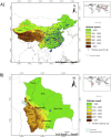
In the present study we analyze the epidemiological data of COVID-19 of Tibet and high-altitude regions of Bolivia and Ecuador, and compare to lowland data, to test the hypothesis that high-altitude inhabitants (+2,500 m above sea-level) are less susceptible to develop severe adverse effects in acute SARS-CoV-2 virus infection. Analysis of available epidemiological data suggest that physiological acclimatization/adaptation that counterbalance the hypoxic environment in high-altitude may protect from severe impact of acute SARS-CoV-2 virus infection. Potential underlying mechanisms such as: (i) a compromised half-live of the virus caused by the high-altitude environment, and (ii) a hypoxia mediated down regulation of angiotensin-converting enzyme 2 (ACE2), which is the main binding target of SARS-CoV-2 virus in the pulmonary epithelium are discussed.
Keywords: COVID-19; Hypoxia; Lung remodeling; UV.
Copyright © 2020. Published by Elsevier B.V.
Figures


Comment in
-
Propagation by COVID-19 at high altitude: Cusco case.Respir Physiol Neurobiol. 2020 Aug;279:103448. doi: 10.1016/j.resp.2020.103448. Epub 2020 May 8. Respir Physiol Neurobiol. 2020. PMID: 32437878 Free PMC article. No abstract available.
-
Caution is needed on the effect of altitude on the pathogenesis of SAR-CoV-2 virus.Respir Physiol Neurobiol. 2020 Aug;279:103464. doi: 10.1016/j.resp.2020.103464. Epub 2020 May 21. Respir Physiol Neurobiol. 2020. PMID: 32447057 Free PMC article. No abstract available.
-
High levels of ambient ozone (O3) may impact COVID-19 in high altitude mountain environments.Respir Physiol Neurobiol. 2020 Sep;280:103487. doi: 10.1016/j.resp.2020.103487. Epub 2020 Jun 30. Respir Physiol Neurobiol. 2020. PMID: 32619691 Free PMC article. No abstract available.
-
Letter to the Editor: Influence of Altitude on the Prevalence and Case Fatality Rate of COVID-19 in Peru.High Alt Med Biol. 2020 Dec;21(4):426-427. doi: 10.1089/ham.2020.0133. Epub 2020 Aug 14. High Alt Med Biol. 2020. PMID: 32803989 No abstract available.
References
-
- Andrade M. Pagina siete; Bolivia: 2020. La radiación ultravioleta en tiempos de cuarentena.https://www.paginasiete.bo/opinion/2020/4/10/la-radiacion-ultravioleta-e...
-
- Dang Z., Su S., Jin G., Nan X., Ma L., Li Z., Lu D., Ge R. Tsantan Sumtang attenuated chronic hypoxia-induced right ventricular structure remodeling and fibrosis by equilibrating local ACE-AngII-AT1R/ACE2-Ang1-7-Mas axis in rat. J. Ethnopharmacol. 2020;250:112470. doi: 10.1016/j.jep.2019.112470. - DOI - PubMed
-
- Gelek L. Radio Free Asia; 2020. Schools in Tibet to Reopen as COVID-19 Fears Subside.https://www.rfa.org/english/news/tibet/school-coronavirus-reopen-0317202...
-
- Gobierno-de-la-Republica-de-Ecuador . 2020. Coronavirus Ecuador.https://coronavirusecuadorcom
MeSH terms
Substances
LinkOut - more resources
Full Text Sources
Medical
Miscellaneous

