. 2020 Dec;97(6):814-822.
doi: 10.1007/s11524-020-00436-8.

Geospatial Variations and Neighborhood Deprivation in Drug-Related Admissions and Overdoses

Affiliations

Geospatial Variations and Neighborhood Deprivation in Drug-Related Admissions and Overdoses

Julien Cobert et al. J Urban Health. 2020 Dec.

Abstract

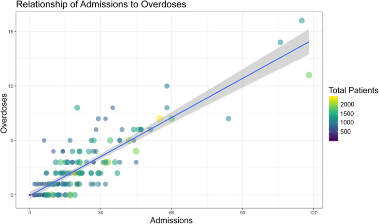
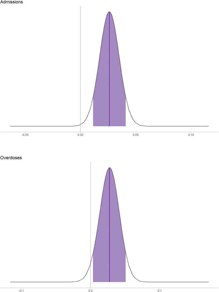
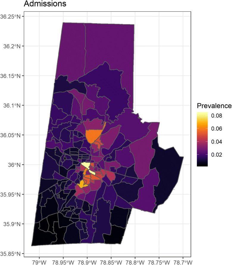
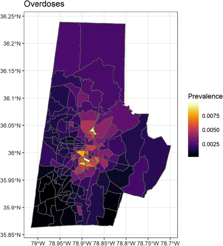
Drug overdoses are a national and global epidemic. However, while overdoses are inextricably linked to social, demographic, and geographical determinants, geospatial patterns of drug-related admissions and overdoses at the neighborhood level remain poorly studied. The objective of this paper is to investigate spatial distributions of patients admitted for drug-related admissions and overdoses from a large, urban, tertiary care center using electronic health record data. Additionally, these spatial distributions were adjusted for a validated socioeconomic index called the Area Deprivation Index (ADI). We showed spatial heterogeneity in patients admitted for opioid, amphetamine, and psychostimulant-related diagnoses and overdoses. While ADI was associated with drug-related admissions, it did not correct for spatial variations and could not account alone for this spatial heterogeneity.

Keywords: Area deprivation; Drug overdoses; Epidemiology; Opioid epidemic; Socioeconomics.


Figures

Fig. 1
Fig. 1
Scatterplot of drug-related admissions vs overdoses with point size and color mapping to the total number of patients
Fig. 2
Fig. 2
Posterior fixed effects plot looking at ADI associated with drug-related admissions and overdoses. ADI is scaled such that 1 represents a 20 percentile change in ADI. Note that the distributions do not cover 0 and thus would be extremely improbable that there is no effect of ADI on admissions for drug-related issues or overdoses
Fig. 3
Fig. 3
Bayesian spatial regression of drug-related admissions adjusted for ADI—color scale represents the rate ratio based on number of Duke patients per census block group
Fig. 4
Fig. 4
Bayesian spatial regression of drug-related overdoses adjusted for ADI—color scale represents the rate ratio based on number of Duke patients per census block group

References

    1. Visconti AJ, Santos GM, Lemos NP, Burke C, Coffin PO. Opioid overdose deaths in the city and county of San Francisco: prevalence, distribution, and disparities. J Urban Health. 2015;92(4):758–772. doi: 10.1007/s11524-015-9967-y. - DOI - PMC - PubMed
    1. Garfield J. E D: fatal overdose trends in major us cities: 1990–1997. Addiction Research & Thery. 2001;9(5):425–436. doi: 10.3109/16066350109141762. - DOI
    1. Brownstein JS, Green TC, Cassidy TA, Butler SF. Geographic information systems and pharmacoepidemiology: using spatial cluster detection to monitor local patterns of prescription opioid abuse. Pharmacoepidemiol Drug Saf. 2010;19(6):627–637. doi: 10.1002/pds.1939. - DOI - PMC - PubMed
    1. Havens JR, Talbert JC, Walker R, Leedham C, Leukefeld CG. Trends in controlled-release oxycodone (OxyContin) prescribing among Medicaid recipients in Kentucky, 1998-2002. J Rural Health. 2006;22(3):276–278. doi: 10.1111/j.1748-0361.2006.00046.x. - DOI - PubMed
    1. Dasgupta N, Jonsson Funk M, Brownstein J. Comparing unintentional opioid poisoning mortality in metropolitan and non-metropolitan counties, United States, 1999–2003. In: Thomas Y, Richardson D, Cheung I, editors. Geography and drug addiction. New York: Springer; 2008.