Review
. 2020 May 18;11(1):2458.
doi: 10.1038/s41467-020-16236-2.

Representing the function and sensitivity of coastal interfaces in Earth system models

Affiliations
Review

Representing the function and sensitivity of coastal interfaces in Earth system models

Nicholas D Ward et al. Nat Commun. .

Abstract

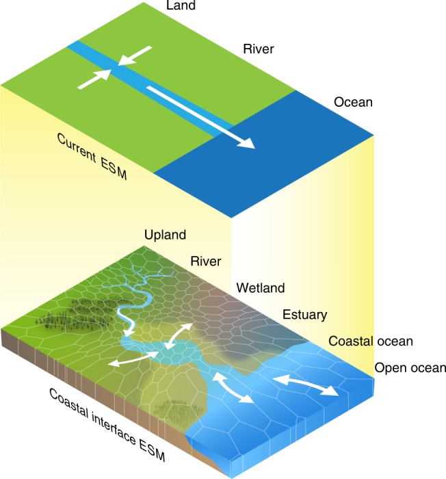
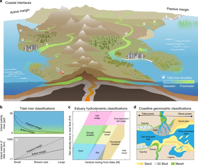
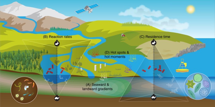
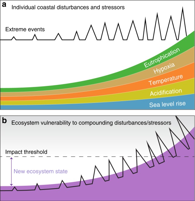
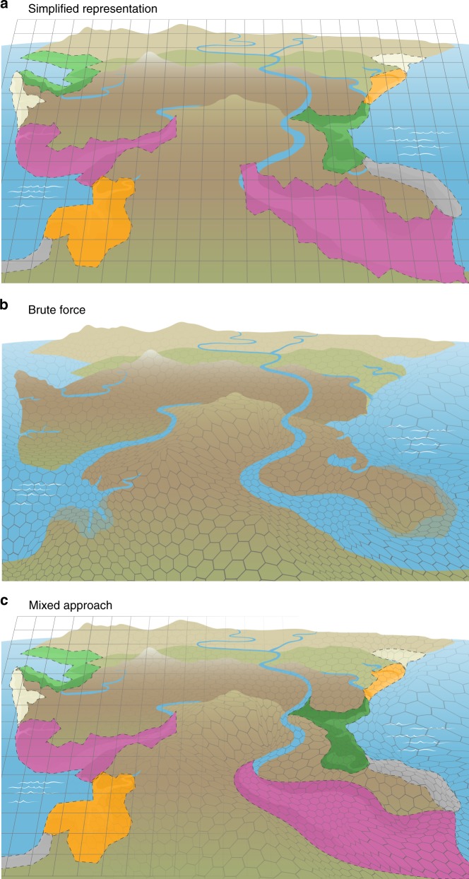
Between the land and ocean, diverse coastal ecosystems transform, store, and transport material. Across these interfaces, the dynamic exchange of energy and matter is driven by hydrological and hydrodynamic processes such as river and groundwater discharge, tides, waves, and storms. These dynamics regulate ecosystem functions and Earth's climate, yet global models lack representation of coastal processes and related feedbacks, impeding their predictions of coastal and global responses to change. Here, we assess existing coastal monitoring networks and regional models, existing challenges in these efforts, and recommend a path towards development of global models that more robustly reflect the coastal interface.


Conflict of interest statement

The authors declare no competing interests.

Figures

Fig. 1
Fig. 1. Earth system model representation of the coastal interface.
Current Earth system models (ESMs) represent the land and ocean as disconnected systems, with freshwater discharge being the only meaningful connection. Next-generation models should represent land–sea connections by incorporating coastal features such as the tidal rivers, wetlands, estuaries, the continental shelf, and tidal exchange across the coastal terrestrial–aquatic interface. This likely necessitates coupling different models to produce details at the sub-grid scale.
Fig. 2
Fig. 2. Generalizable features of coastal ecosystems.
a, b The inland extent of tidal influence on river flow increases with stream order, while the inland intrusion of salinity decreases. Rivers (and groundwater tables) on an active continental margin (e.g., US West Coast) are generally steeper in elevation, reducing how far inland tides permeate. Gradients in vegetation are influenced by these characteristics. c Estuarine environments can be broadly classified by their hydrodynamic properties such as net current velocity due to river flow (Frf) and how effectively tides mix a stratified estuary (M); fjords have low freshwater and tidal velocity scales due to their great depth whereas salt wedges have high contributions from rivers and a wide range of tidal contributions (adapted from Geyer and MacCready). d Classifications of shallow water depositional environments along the coast can be categorized based on the ratio of wave power to tidal power and whether they are regressive (i.e., net land gain; top half of the diagram) or transgressive (i.e., net land loss; bottom half of the diagram) environments. The top half of the diagram shows regressive environments such as deltas and strand plains. The bottom of the diagram shows transgressive environments such as estuaries and barrier lagoons. Open coast tidal flats and shelf environments can be linked to either type of coast with shelf width decreasing during regression (adapted from Steel and Milliken).
Fig. 3
Fig. 3. Biogeochemical characteristics of coastal interfaces.
a Two-way exchange of water and materials between terrestrial and marine environments drive gradients in geochemical constituents (e.g., ions, carbon, nutrients), plant distribution, and ecosystem functions (e.g., carbon storage, greenhouse gas emissions, sediment accumulation). b Biogeochemical reaction rates generally occur at more rapid timescales (e.g., hours to days) in aquatic systems such as rivers compared to soils and sediments (years to millennia). c Likewise, the residence time of biogeochemical components is short in aquatic environments such as estuaries and the surface ocean compared to the deep ocean and its sediments. d Coastal interface biogeochemistry is complicated by an abundance of hot spots and moments for diverse reactions across scales that can significantly alter expected reaction rates and residence times.
Fig. 4
Fig. 4. Coastal ecosystem disturbances, stressors, and vulnerability.
a Increasing air and water temperatures, water acidification, rates of sea level rise, eutrophication, hypoxia, and frequency/magnitude of extreme storm surge events are among the primary threats to the ecology and hydro-biogeochemistry of coastal interfaces. b Although the resilience of coastal ecosystems is relatively unknown, it is likely that compounding disturbances and chronic stress will eventually exceed their impact threshold, resulting in widespread collapse of ecological function. Additional drivers of change not shown include land use change, river impoundment, natural resource extraction, invasive species, droughts, floods, and fires (concept inspired by McDowell et al.).
Fig. 5
Fig. 5. Representing coastal interfaces in Earth system models.
a Perhaps the simplest approach would be to classify coastal interfaces based on a series of functional types for their main features (i.e., different types of tidal rivers, estuaries, intertidal ecosystems, and shoreline ecosystems; Fig. 2). Process parameterizations derived from synthesized data would be applied to the fraction of a pixel occupied by each feature rather than the current state of the art, which assigns some fraction of coastal pixels as land and some fraction as ocean. b The most sophisticated approach would be to couple high-resolution regional coastal interface models with coarser resolution Earth system models using a variable pixel size (i.e., Voronoi mesh). c Perhaps the most feasible and robust approach would be a combination of the two, whereby existing or strategically developed high-resolution models are coupled, and classifications of functional types are applied to systems where data required for high-resolution models are not available.

References

    1. US Department of Energy. Research priorities to incorporate terrestrial–aquatic interfaces in Earth system models workshop (DOE, 2017).
    1. Canuel EA, Cammer SS, McIntosh HA, Pondell CR. Climate change impacts on the organic carbon cycle at the land–ocean interface. Annu. Rev. Earth Planet. Sci. 2012;40:685–711. doi: 10.1146/annurev-earth-042711-105511. - DOI
    1. Costanza R, et al. Twenty years of ecosystem services: how far have we come and how far do we still need to go? Ecosyst. Serv. 2017;28:1–16. doi: 10.1016/j.ecoser.2017.09.008. - DOI
    1. Martínez ML, et al. The coasts of our world: ecological, economic and social importance. Ecol. Econ. 2007;63:254–272. doi: 10.1016/j.ecolecon.2006.10.022. - DOI
    1. International Chamber of Shipping. Shipping and world trade. ICShttps://www.ics-shipping.org/shipping-facts/shipping-and-world-trade (2020).

Publication types