

doi: 10.3389/fpubh.2020.00126.
eCollection 2020.
Time Series of Potential US Wildland Fire Smoke Exposures
Affiliations
- PMID: 32426315
- PMCID: PMC7212435
- DOI: 10.3389/fpubh.2020.00126
Item in Clipboard
Time Series of Potential US Wildland Fire Smoke Exposures
Front Public Health.
.
No abstract available
Keywords: air pollutants; climate change; exposure; remote sensing; smoke; wildfire.
Figures
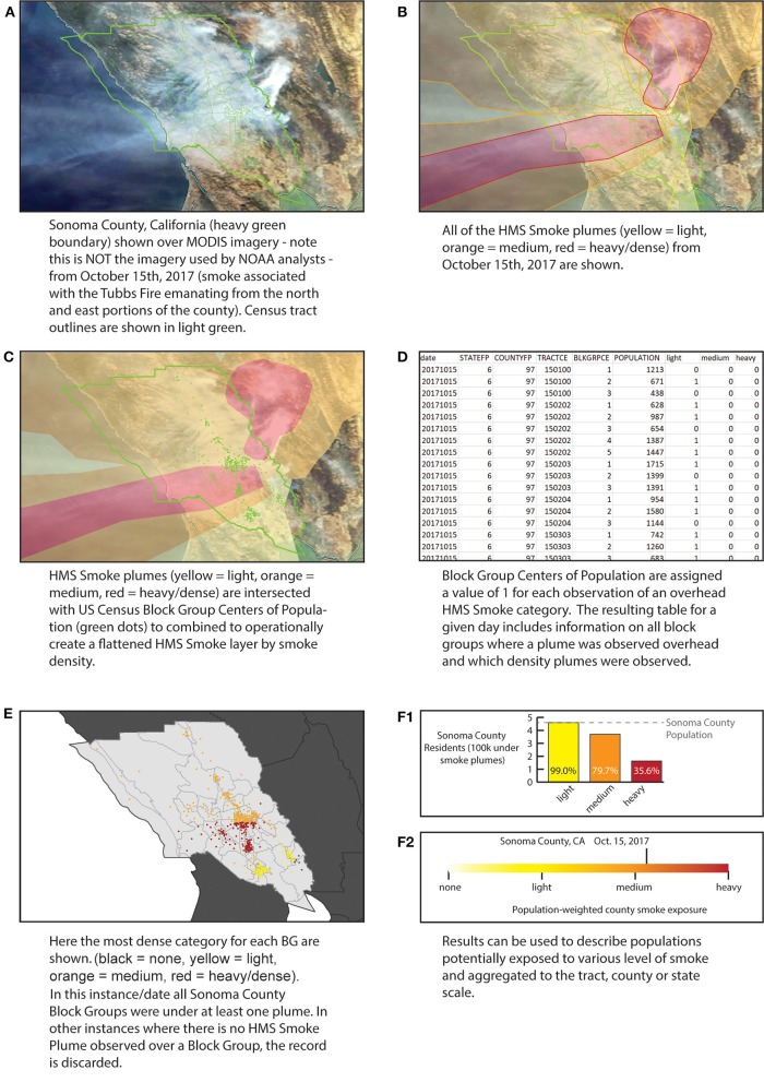
Processing of the data using example of Sonoma County Oct. 11, 2017. (A) Example visible imagery; (B) HMS Smoke plumes layer for Oct. 11, 2017; (C) Simplification of all plumes by density; (D) resulting table of the intersection of plumes and centers of population; (E) Resulting maximum density smoke assignment for Sonoma Block Group centers of population; (F1) Total number of Sonoma residents under each density category; (F2) Population-weighted smoke density for Sonoma County.
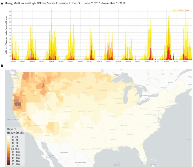
Examples of how the data may be visualized and reused. (A) Shows a time series for the number of people under different categories of HMS Smoke for the full dataset (all US, June 2010–Nov 1, 2019); (B) The number of days of heavy smoke for any part of the county (contiguous US, June 2010–Nov 1, 2019).
Similar articles
-
The firestorm within: A narrative review of extreme heat and wildfire smoke effects on brain health.Sci Total Environ. 2024 Apr 20;922:171239. doi: 10.1016/j.scitotenv.2024.171239. Epub 2024 Feb 27. Sci Total Environ. 2024. PMID: 38417511 Review.
-
Editorial: Understanding and Communicating Wildland Fire Smoke Risk.Front Public Health. 2021 Sep 29;9:721823. doi: 10.3389/fpubh.2021.721823. eCollection 2021. Front Public Health. 2021. PMID: 34660515 Free PMC article. No abstract available.
-
Out-of-Hospital Cardiac Arrests and Wildfire-Related Particulate Matter During 2015-2017 California Wildfires.J Am Heart Assoc. 2020 Apr 21;9(8):e014125. doi: 10.1161/JAHA.119.014125. Epub 2020 Apr 15. J Am Heart Assoc. 2020. PMID: 32290746 Free PMC article.
-
Contribution of Wildland-Fire Smoke to US PM2.5 and Its Influence on Recent Trends.Environ Sci Technol. 2019 Feb 19;53(4):1797-1804. doi: 10.1021/acs.est.8b05430. Epub 2019 Feb 11. Environ Sci Technol. 2019. PMID: 30681842
-
Wildfire Smoke Exposure during Pregnancy: A Review of Potential Mechanisms of Placental Toxicity, Impact on Obstetric Outcomes, and Strategies to Reduce Exposure.Int J Environ Res Public Health. 2022 Oct 22;19(21):13727. doi: 10.3390/ijerph192113727. Int J Environ Res Public Health. 2022. PMID: 36360613 Free PMC article. Review.
Cited by
-
The Camp fire and perinatal health: an example of the generalized synthetic control method to identify susceptible windows of exposure.Am J Epidemiol. 2025 Mar 4;194(3):722-729. doi: 10.1093/aje/kwae261. Am J Epidemiol. 2025. PMID: 39117573 Free PMC article.
-
Adverse Birth Outcomes Associated with Heat Stress and Wildfire Smoke Exposure During Preconception and Pregnancy.Environ Sci Technol. 2025 Jul 1;59(25):12458-12471. doi: 10.1021/acs.est.4c10194. Epub 2025 Jun 18. Environ Sci Technol. 2025. PMID: 40532130 Free PMC article.
-
A Wildfire Smoke Detection System Using Unmanned Aerial Vehicle Images Based on the Optimized YOLOv5.Sensors (Basel). 2022 Dec 1;22(23):9384. doi: 10.3390/s22239384. Sensors (Basel). 2022. PMID: 36502081 Free PMC article.
-
Social Vulnerability in US Communities Affected by Wildfire Smoke, 2011 to 2021.Am J Public Health. 2023 Jul;113(7):759-767. doi: 10.2105/AJPH.2023.307286. Am J Public Health. 2023. PMID: 37285572 Free PMC article.
-
A State of the Science Review of Wildfire-Specific Fine Particulate Matter Data Sources, Methods, and Models.Environ Health Perspect. 2025 Jun;133(6):66001. doi: 10.1289/EHP15672. Epub 2025 Jun 11. Environ Health Perspect. 2025. PMID: 40324008 Free PMC article.
References
-
- Justice CO, Giglio L, Korontzi S, Owens J, Morisette JT, Roy D, et al. The MODIS fire products. Remote Sens Environ. (2002) 83:244–62. 10.1016/S0034-4257(02)00076-7 - DOI
-
- Giglio L, Descloitres J, Justice CO, Kaufman YJ. An enhanced contextual fire detection algorithm for MODIS. Remote Sens Environ. (2003) 87:273–82. 10.1016/S0034-4257(03)00184-6 - DOI
-
- Prins EM, Menzel WP. Geostationary satellite detection of bio mass burning in South America. Int J Remote Sens. (1992) 13:2783–99. 10.1080/01431169208904081 - DOI
-
- Li Z, Nadon S, Cihlar J. Satellite-based detection of Canadian boreal forest fires: development and application of the algorithm. Int J Remote Sens. (2000) 21:3057–69. 10.1080/01431160050144956 - DOI
-
- Ruminski M, Kondragunta S, Draxler R, Zeng J. Recent changes to the hazard mapping system. In: Proceedings of the 15th International Emission Inventory Conference, Vol. 15. (2006). p. 18.
MeSH terms
Substances
LinkOut - more resources
Full Text Sources
Medical