

Dataset of seismic ambient vibrations from the quaternary Norcia basin (central Italy)
- PMID: 32514415
- PMCID: PMC7267715
- DOI: 10.1016/j.dib.2020.105709
Dataset of seismic ambient vibrations from the quaternary Norcia basin (central Italy)
Abstract
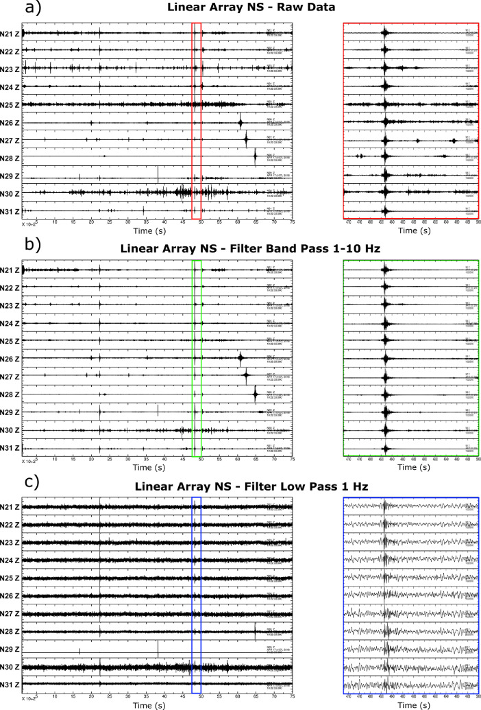
Central Italy was affected by a long seismic sequence in 2016 and 2017, characterized by five main-shocks with Mw>5.0. The Mw 6.5 mainshock occurred on 30 October 2016 close to the town of Norcia, located in the intra-Apennine Norcia basin. Different degrees of damages were observed during this seismic crisis, caused by a variable seismic shaking. This was also due to important 1D and 2D variation of Quaternary fluvio-lacustrine sediments infilling the basin. Following such considerations, a new geophysical dataset of seismic vibration measurements was acquired in the study area during the period April 2017-November 2019. We collected mainly single-seismic station noise data, to infer the distribution of resonance frequency (f0) of the basin. A total of 60 sites were measured to cover the entire extension in the basin. We deployed seismometers along three transects of a total length of 21 km, mostly along the main structural directions of the basin (i.e. NNW-SSE and NE-SW). Two 2D arrays of seismic stations with a elicoidal-shaped geometry, and a set of MASW active data were also acquired in the northern sector of the basin, in order to better constrain the seismic velocity of the sedimentary infilling. These new records have been integrated with available geological information in order to reconstruct the deep structure of the basin, as discussed in the research paper by [2]. The entire dataset used in [2] is here provided, together with 7 additional records recovered for the basin (i.e. N54-N60) and ancillary open-source geospatial data. The dataset can be used for different purposes: specific research on the Norcia basin, comparative studies on similar areas around the world, development of new data modeling and testing of new analysis software, and as a training dataset for machine learning applications.
Keywords: Active seismic; GIS data; Norcia basin; Seismic ambient vibrations; Seismic array and ambient noise analysis; Site effects.
© 2020 The Author(s).
Conflict of interest statement
The authors declare that they have no known competing financial interests or personal relationships which have, or could be perceived to have, influenced the work reported in this article.
Figures


References
-
- Porreca M., Minelli G., Ercoli M., Brobia A., Mancinelli P., Cruciani F., Giorgetti C., Carboni F., Mirabella F., Cavinato G., Cannata A., Pauselli C., Barchi M.R. Seismic reflection profiles and subsurface geology of the area interested by the 2016–2017 earthquake sequence (Central Italy) Tectonics. 2018;37–4:1116–1137. doi: 10.1002/2017TC004915. - DOI
-
- Di Giulio G., Ercoli M., Vassallo M., Porreca M. Investigation of the Norcia basin (Central Italy) through ambient vibration measurements and geological surveys. Eng. Geol. 2020;267 doi: 10.1016/j.enggeo.2020.105501. - DOI
-
- Vassallo M., De Matteis R., Bobbio A., Di Giulio G., Adinolfi G.M., Cantore L., Cogliano R., Fodarella A., Maresca R., Pucillo S., Riccio G. Seismic noise cross-correlation in the urban area of Benevento city (Southern Italy) Geophys. J. Int. 2019;217:1524–1542. doi: 10.1093/gji/ggz101. - DOI
-
- Park C.B., Miller R.D., Xia J. Multichannel analysis of surface waves. Geophysics. 1999;64–3:800–808. doi: 10.1190/1.1444590. - DOI
LinkOut - more resources
Full Text Sources
Miscellaneous
