. 2020 Jul 10;10(1):11452.
doi: 10.1038/s41598-020-68237-2.

Sand deposits reveal great earthquakes and tsunamis at Mexican Pacific Coast

Affiliations

Sand deposits reveal great earthquakes and tsunamis at Mexican Pacific Coast

María-Teresa Ramírez-Herrera et al. Sci Rep. .

Abstract

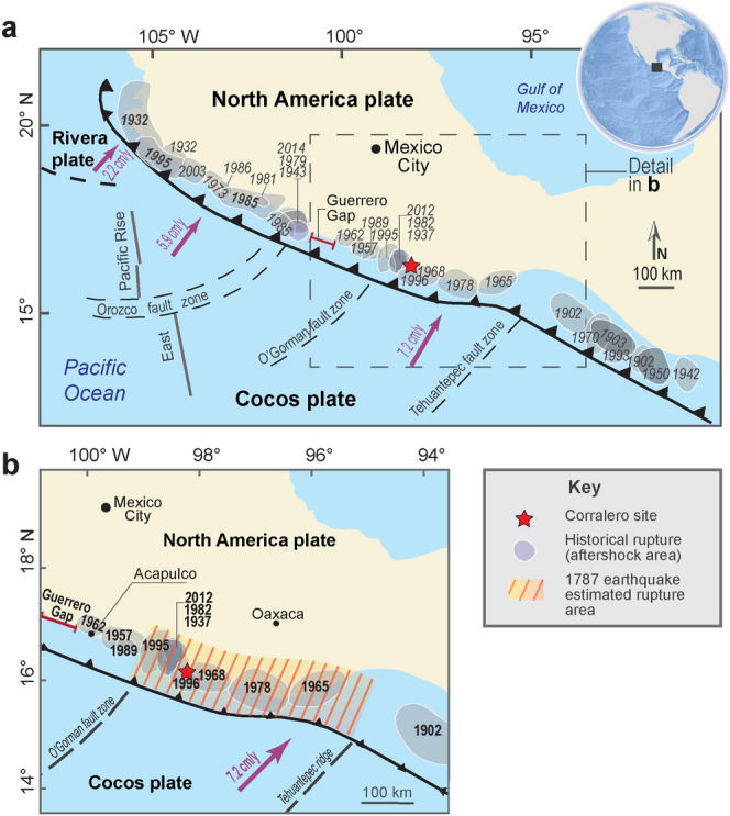
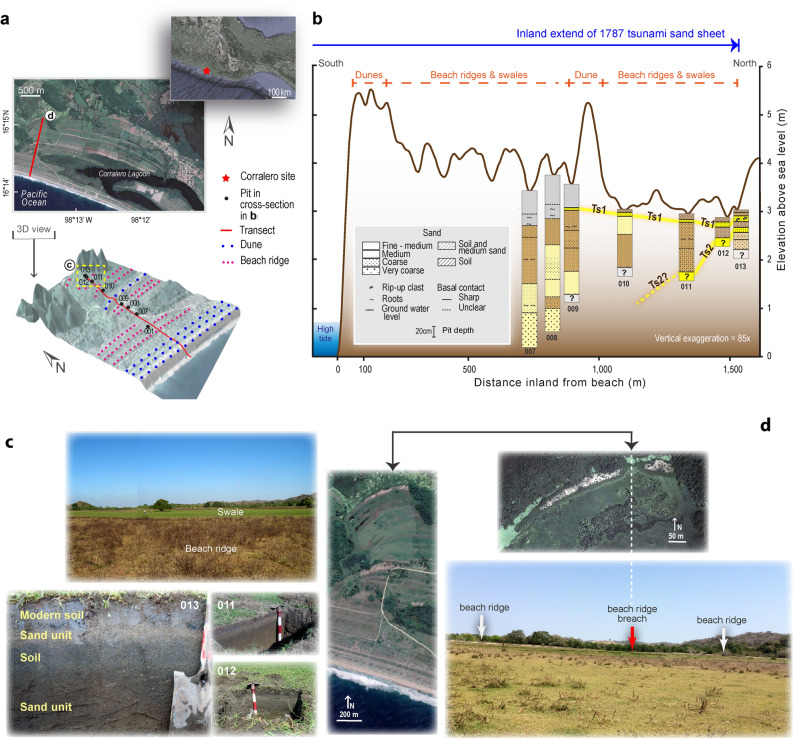
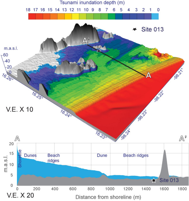
Globally, instrumentally based assessments of tsunamigenic potential of subduction zones have underestimated the magnitude and frequency of great events because of their short time record. Historical and sediment records of large earthquakes and tsunamis have expanded the temporal data and estimated size of these events. Instrumental records suggests that the Mexican Subduction earthquakes produce relatively small tsunamis, however historical records and now geologic evidence suggest that great earthquakes and tsunamis have whipped the Pacific coast of Mexico in the past. The sediment marks of centuries old-tsunamis validate historical records and indicate that large tsunamigenic earthquakes have shaken the Guerrero-Oaxaca region in southern Mexico and had an impact on a bigger stretch of the coast than previously suspected. We present the first geologic evidence of great tsunamis near the trench of a subduction zone previously underestimated as potential source for great earthquakes and tsunamis. Two sandy tsunami deposits extend over 1.5 km inland of the coast. The youngest tsunami deposit is associated with the 1787 great earthquake, M 8.6, producing a giant tsunami that poured over the coast flooding 500 km alongshore the Mexican Pacific coast and up to 6 km inland. The oldest event from a less historically documented event occurred in 1537. The 1787 earthquake, and tsunami and a probable predecessor in 1537, suggest a plausible recurrence interval of 250 years. We prove that the common believe that great tsunamis do not occur on the Mexican Pacific coast cannot be sustained.


Conflict of interest statement

The authors declare no competing interests.

Figures

Figure 1
Figure 1
Maps of study area. Middle America trench and seaward edges of Mexican subduction zone are shown with barbed lines. (a) Mexican subduction zone showing historical rupture (aftershock) areas of the twentieth and twenty-first century earthquakes (modified after https://usuarios.geofisica.unam.mx/vladimir/images/EQ_map_2013_es_clear.jpg). (b) Guerrero and Oaxaca coast showing rupture areas of the most important earthquakes (1937, 1965, 1978, 1982, 1995, 1996 and 2012) and the estimated location of the 1787 event, used in tsunami simulations (Fig. 4), slip modelling and coseismic deformation models (Supplementary Information and Figs. S9, S10, S11).
Figure 2
Figure 2
Summary of tsunami deposits and geomorphic evidence of great tsunami flooding in Corralero, Oaxaca. Supporting data in Supplementary Table S1 Supplementary information: Table S2 and Fig. S7. (a) Location map of study area and 3-D Lidar-based model (5 m resolution) of the bare surface at Corralero coastal plain, showing sand dunes, beach ridges and swales. (b) Cross section of pits, sand units correlated by stratigraphic and sediment characteristics, TSI shows inland extent of 1787 tsunami sand sheet. Microfossil, sediment elemental composition and 210Pb dates of pit 013 are shown in detail in Fig. 3. (c) Upper picture shows beach ridge and swale (people and a large tree standing for scale); lower pictures show pits at swales with evidence on sand units with abrupt basal contacts and soils beneath and above them. (d) Beach ridge breaches shown on satellite images (left and upper pictures) and on field-based photograph (lower picture), indicating tsunami breaching.
Figure 3
Figure 3
Evidence of great tsunamis at Corralero. Cross-section of pit 013. Yellow sand units indicate tsunami deposits TS1 and TS2 related to the great 1787 earthquake (M8.6) and tsunami (Supporting data in Supplementary Table S2 and Supplementary Fig. S7) and the probable 1537 earthquake and tsunami, respectively. Elemental composition of sediments shows increase of element ratios indicative of marine flooding (Supplementary Fig. S8). Diatom assemblages and dinoflagellate indicative of marine origin suggest tsunami deposits related to the great 1787 and the 1537 earthquakes (Supporting details in Supplementary Fig. S7, Supplementary Information 1).
Figure 4
Figure 4
Tsunami inundation depth model. Tsunami inundation depth model based on hypothetical earthquake estimated rupture area shown in Fig. 1b. (a) Tsunami inundation depth showing ~ 5 m depth at site 013. Tsunami inundation in this model can reach up to 5 km distance in flat areas which is accordant with historical documents (Supplementary Information 1). (b) Tsunami inundation depth and bare terrain profile.

References

    1. Sawai Y, Namegaya Y, Okamura Y, Satake K, Shishikura M. Challenges of anticipating the 2011 Tohoku earthquake and tsunami using coastal geology. Geophys. Res. Lett. 2012;39:L14302. doi: 10.1029/2012GL053692. - DOI
    1. Bilham R, Engdahl R, Feldl N, Satyabala SP. Partial and complete rupture of the Indo-Andaman Plate Boundary 1847–2004. Seismol. Res. Lett. 2005;76:299–311. doi: 10.1785/gssrl.76.3.299. - DOI
    1. Jankaew K, et al. Medieval forewarning of the 2004 Indian Ocean tsunami in Thailand. Nature. 2008;455:1228–1231. doi: 10.1038/nature07373. - DOI
    1. Cisternas M, et al. Predecessors of the giant 1960 Chile earthquake. Nature. 2005;437:404–407. doi: 10.1038/nature03943. - DOI - PubMed
    1. Nelson AR, et al. Radiocarbon evidence for extensive plate-boundary rupture about 300 years ago at the Cascadia subduction zone. Nature. 1995;378:371–374. doi: 10.1038/378371a0. - DOI

Publication types