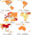
Geolocated Twitter social media data to describe the geographic spread of SARS-CoV-2
- PMID: 32701135
- PMCID: PMC7454796
- DOI: 10.1093/jtm/taaa120
Geolocated Twitter social media data to describe the geographic spread of SARS-CoV-2
Abstract
Openly available, geotagged Twitter data from 2013 to 2015 was used to estimate the 2019–2020 human mobility patterns in and outside of China to predict the spatiotemporal spread of severe acute respiratory syndrome coronavirus 2. Countries with the highest number of visiting Twitter users outside of China were the USA, Japan, UK, Germany and Turkey. A high correlation was observed when comparing country-level Twitter user visits and reported cases.
Keywords: COVID-19; SARS-CoV2; Twitter; epidemiology; geospatial; mobility; pandemic.
Figures

References
-
- WHO Coronavirus disease 2019 (COVID-19). https://www.who.int/docs/default-source/coronaviruse/situation-reports/2... (1 August 2020, date last accessed)
-
- KraemerMUG D, Bogoch I et al. . Use of Twitter social media activity as a proxy for human mobility to predict the spatiotemporal spread of COVID-19 at global level. Geospatial Health 2020; 15:882. - PubMed
MeSH terms
LinkOut - more resources
Full Text Sources
Miscellaneous

