. 2020 Jul 22;17(15):5285.
doi: 10.3390/ijerph17155285.

Valley Fever: Environmental Risk Factors and Exposure Pathways Deduced from Field Measurements in California

Affiliations

Valley Fever: Environmental Risk Factors and Exposure Pathways Deduced from Field Measurements in California

Antje Lauer et al. Int J Environ Res Public Health. .

Abstract

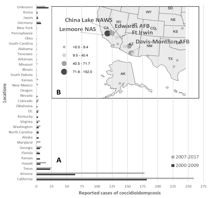
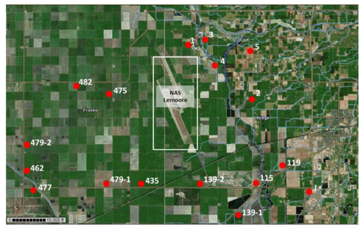
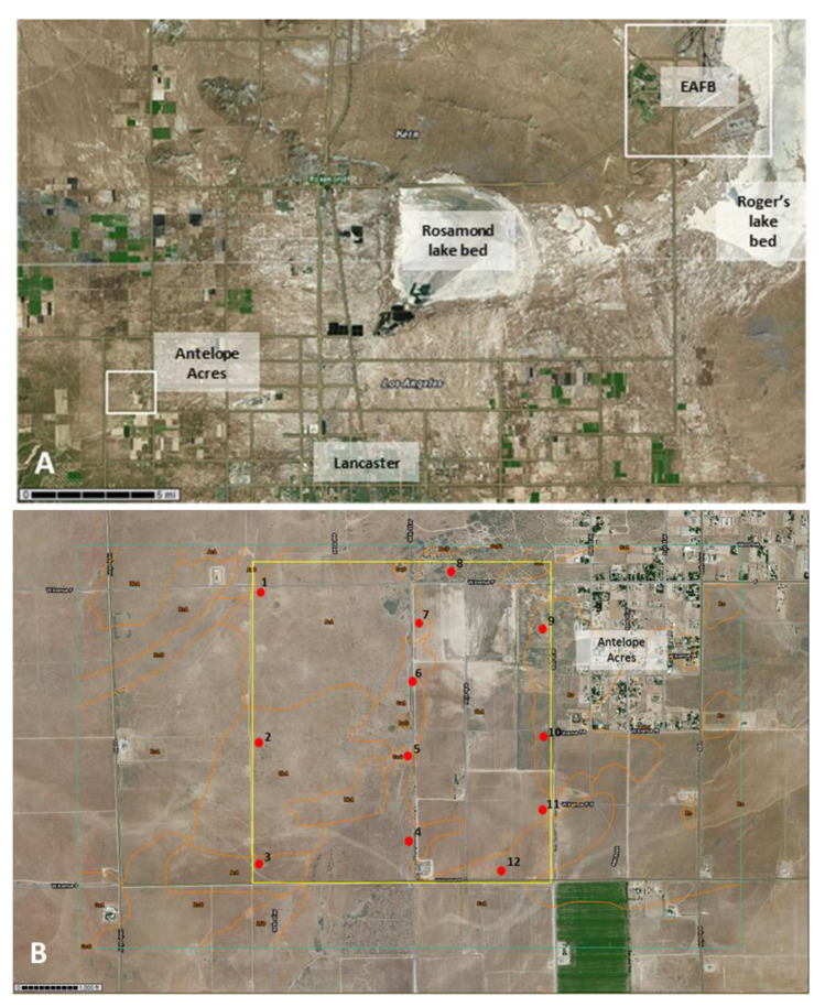
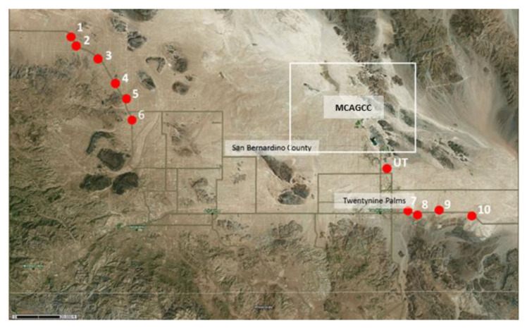
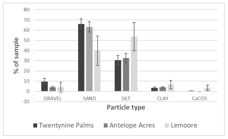
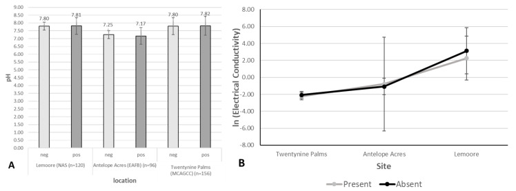
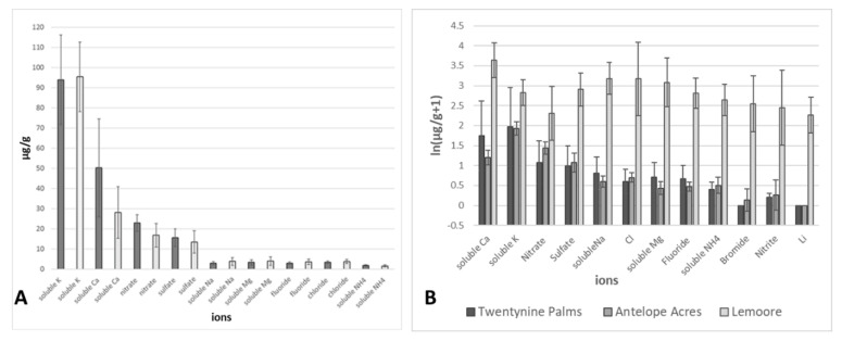
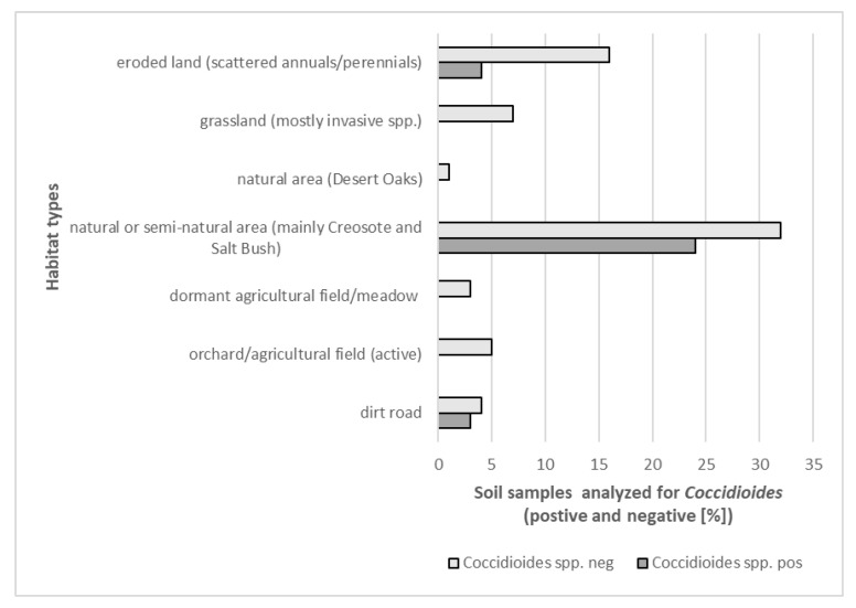
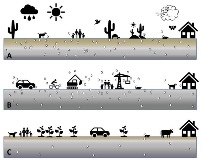
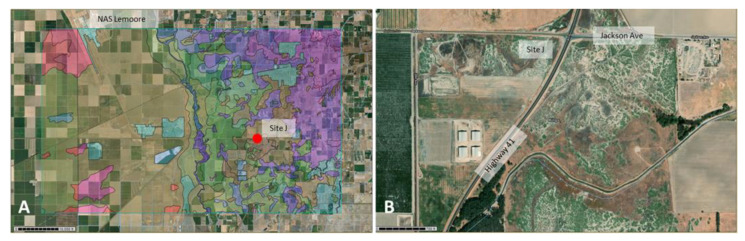
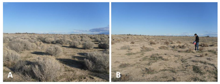
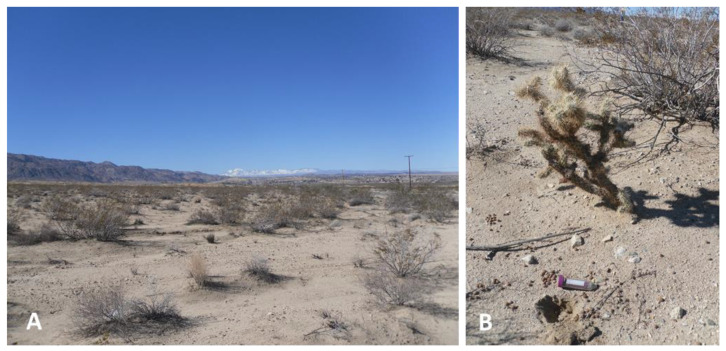
Coccidioidomycosis, also known as Valley fever, has been reported among military personnel in Coccidioides-endemic areas of the southwestern United States since World War II. In this study, the prevalence of Coccidioides was confirmed in different soil and dust samples collected near three military bases in California using DNA extraction and Polymerase Chain Reaction (PCR) methods. Analyses of physical and chemical parameters revealed no significant differences between Coccidioides-positive and -negative sites. Soil samples collected in the Mojave Desert (near Twentynine Palms MCAGCC) showed the highest percentage of Coccidioides-positive soil and dust samples. Samples from the San Joaquin Valley (near NAS Lemoore) showed the lowest percentage of positive samples and were restricted to remnants of semi-natural areas between agricultural fields. Our results suggest that soil disturbance around all three military bases investigated poses a potential Coccidioides exposure risk for military personnel and the public. We conclude that once lands have been severely disturbed from their original state, they become less suitable for Coccidioides growth. We propose a conceptual framework for understanding exposure where disturbance of soils that exhibit natural or remnants of native vegetation (Creosote and Salt Bush) generate a high risk of exposure to the pathogen, likely during dry periods. In contrast, Coccidioides-positive sites, when undisturbed, will not pose a high risk of exposure.

Keywords: Coccidioides; Mojave Desert; PM10; Valley fever; coccidioidomycosis; dust; exposure; fungus; health hazard; military; pathogen; soil.


Conflict of interest statement

The authors declare no conflict of interest.

Figures

Figure 1
Figure 1
Number of diagnosed cases of coccidioidomycosis between 2000 and 2017 among active military. Data were compiled from two studies: Medical Surveillance Monthly Report (MSMR) 2010 Vol. 17(12):13 [25], and MSMR 2018 Vol. 25(4):2–5 [29] (A). Incidence of coccidioidomycosis within the active component, U.S. Armed Forces, 2000–2013 per 100,000 persons/year in the southwestern U.S. (adopted from MSMR 2014, Vol. 21(16):12–14 [26]) (B).
Figure 2
Figure 2
Sampling locations (indicated as red dots) around NAS Lemoore (in the center indicated within white rectangle) in Kings County and Fresno County, CA. Several subsamples were collected at each indicated sampling site (site 151 is off the map, south of site 139-1).
Figure 3
Figure 3
Sampling area in the western Mojave Desert where EAFB is located (upper right corner within the white square). Rosamond dry lakebed (center) and Roger’s dry lakebed (upper right) can be seen. The sampling location is indicated with a smaller white square southwest of Rosamond dry lakebed (A). The sampling area west of Antelope Acres with individual sampling locations are indicated as red dots (B). Several subsamples were collected at each indicated sampling site. Orange lines indicate borders of different soil types (United States Department of Agriculture (USDA) websoilsurvey (WSS) database).
Figure 4
Figure 4
Sampling location (indicated as red dots) near Twentynine Palms MCAGCC (within white square). Several subsamples were collected at each indicated sampling site (site UT = Utah Trail).
Figure 5
Figure 5
PI-SWERL® includes a cylindrical chamber that allows for recreating surface wind shear and measuring the resultant dust emissions. The orange case contains filter sampling apparatus with PM10 size selective cyclone (A). TRAKERTM was developed as a tool to measure emissions of particulate matter as a result of vehicular travel on unpaved roads (B).
Figure 6
Figure 6
Examples of PCR results obtained with both diagnostic primer pairs using soil DNA extracts (5–7 cm depth) from Antelope Acres west of EAFB. Amplicons obtained with primer pair ITSC1Af/r (~120 bp) (A). Amplicons obtained with primer pair EC3/EC100 (~500 bp). A 100 bp DNA ladder can be seen in the 2% agarose gel on the left (B) (PC = positive control, NC = negative control).
Figure 7
Figure 7
Comparison of grain size analyses of representative soil samples from all three main sampling locations. The graph shows the percentage of each soil particle type in soils from the three locations investigated (n = 18 for Twentynine Palms, n = 12 for Antelope Acres, and n = 7 for Lemoore sites. Error bars represent 95% Confidence Intervals).
Figure 8
Figure 8
(A) Soil pH averages for Coccidioides DNA-positive samples (dark grey) and Coccidioides DNA-negative samples (light grey) from all the three locations (averages, error bars are based on 95% confidence). (B) Ln (Electrical Conductivity) by site and presence of Coccidioides DNA. Twentynine Palms: Coccidioides DNA present n = 10, Coccidioides DNA absent n = 8. Antelope Acres: Coccidioides DNA present n = 3, Coccidioides DNA absent n = 6. Lemoore: Coccidioides DNA present n = 3, Coccidioides DNA absent n = 3.
Figure 9
Figure 9
(A) Soil ion composition was not statistically different in soils where DNA of Coccidioides was detected (dark grey bars) and where DNA of the pathogen was not detected (light grey bars). (B) Results of soil ion analysis for selected Coccidioides DNA-positive and -negative samples form Twentynine Palms, Antelope Acres, and Lemoore (data: all sites combined: NAS Lemoore, Antelope Acres (west of EAFB), and MCAGCC Twentynine Palms, n = 41).
Figure 10
Figure 10
Detection of Coccidioides DNA in habitats that differ in the degree of human influence. Statistically significant differences were determined between different habitat types and the presence or absence of the pathogen DNA (p-values < 0.001, linear regression; see Methods and text).
Figure 11
Figure 11
Conceptual model of environmental exposure pathways for Valley fever. (A) Undisturbed natural landscape with intact soil and diverse vegetation, including native species. Coccidioides growth supported, but few arthroconidia airborne (indicated as white, small, oval-shaped objects with black dots). (B) Freshly disturbed natural landscape with reduced or no vegetation. Coccidioides growth supported with increased airborne arthroconidia. Vehicle traffic, off-road biking, construction, as well as oil drilling are factors that highly erode soils. (C) Aged disturbed landscape with reduced or altered vegetation, such as agricultural fields under management, orchards with suppressed vegetation between trees, or dairy farms with high manure contamination of the soil. Coccidioides growth is inhibited and few arthroconidia become airborne.
Figure 12
Figure 12
Location of C. immitis DNA-positive site J southeast of NAS Lemoore (red dot). Different soil types are indicated in colors with Boggs and Lemoore sandy loam in brown. These types of soils comprise ~6.5% of the area of interest (AOI) in this picture (A). Magnified satellite view of site J showing the extent of soil disturbance and its proximity to Highway 41 and Jackson Avenue, two highly frequented roads south of Lemoore (B).
Figure 13
Figure 13
Sites 5 (A) and site 6 (B) west of Antelope Acres and EAFB where C. immitis DNA was detected, with scattered common rabbit brush and Salt Bush. Site 6 showed increased disturbance and erosion compared to site 5.
Figure 14
Figure 14
Overview of site 8 near Twentynine Palms showing scattered vegetation of predominantly Creosote (Larrea tridentata) (A). C. posadasii DNA-positive sampling site 9-3 near a Pencil Cholla (Cylindropuntia ramosissima) and Creosote in the background (B). Note the abundant rodent pellets nearby.

References

    1. Daubenmire R.F. Merriam’s life zones of North America. Quart. Rev. Biol. 1938;13:327–332. doi: 10.1086/394564. - DOI
    1. Elconin A.F., Egeberg R.O., Egeberg M.C. Significance of soil salinity on the ecology of Coccidioides immitis. J. Bacteriol. 1964;87:500–503. doi: 10.1128/JB.87.3.500-503.1964. - DOI - PMC - PubMed
    1. Maddy K.T., Coccozza J. The probable geographic distribution of Coccidioides immitis in Mexico. Bol. Oficina Sanit. Panama. 1964;57:44–54. - PubMed
    1. Maddy K.T. Observations on Coccidioides immitis found growing naturally in soil. Ariz. Med. 1965;22:281–288. - PubMed
    1. Lacy G.H., Swatek F.E. Soil ecology of Coccidioides immitis at Amerindian middens in California. Appl. Environ. Microbiol. 1974;27:379–388. doi: 10.1128/AEM.27.2.379-388.1974. - DOI - PMC - PubMed

Publication types