Multicenter Study
. 2020 Aug 3;11(1):3870.
doi: 10.1038/s41467-020-17688-2.

Blind spots in global soil biodiversity and ecosystem function research

Affiliations
Multicenter Study

Blind spots in global soil biodiversity and ecosystem function research

Carlos A Guerra et al. Nat Commun. .

Abstract

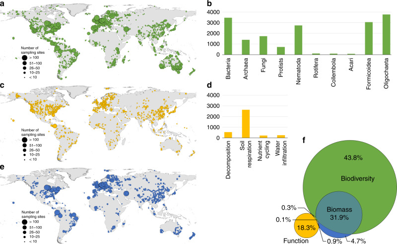
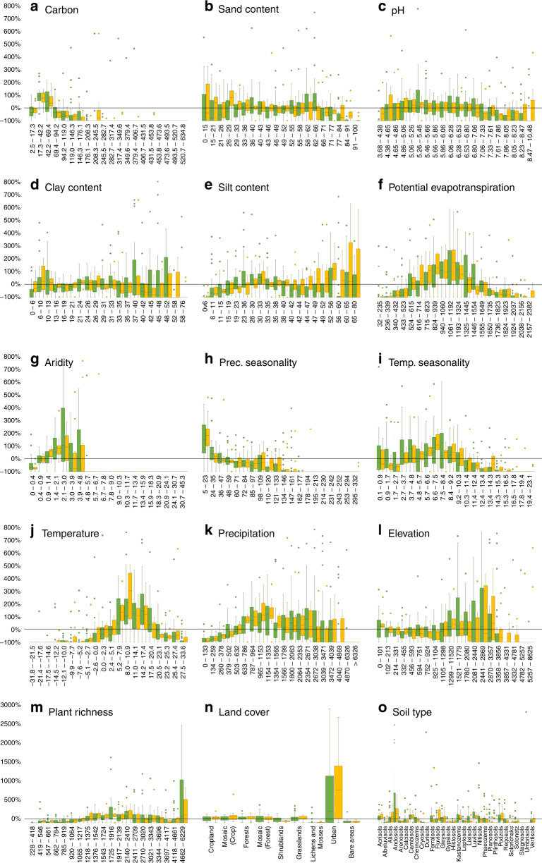
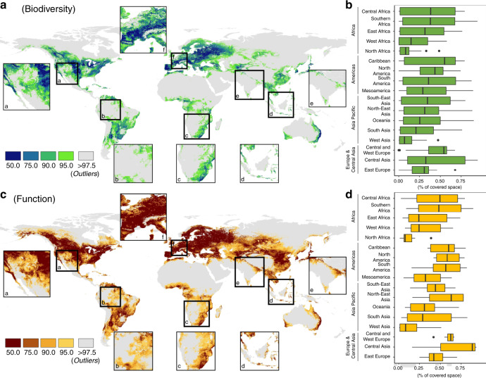
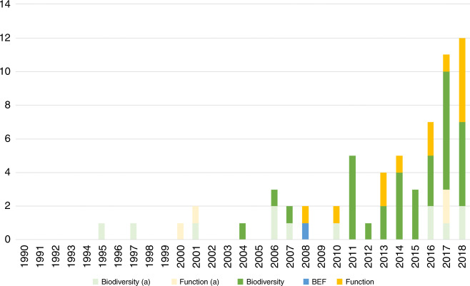
Soils harbor a substantial fraction of the world's biodiversity, contributing to many crucial ecosystem functions. It is thus essential to identify general macroecological patterns related to the distribution and functioning of soil organisms to support their conservation and consideration by governance. These macroecological analyses need to represent the diversity of environmental conditions that can be found worldwide. Here we identify and characterize existing environmental gaps in soil taxa and ecosystem functioning data across soil macroecological studies and 17,186 sampling sites across the globe. These data gaps include important spatial, environmental, taxonomic, and functional gaps, and an almost complete absence of temporally explicit data. We also identify the limitations of soil macroecological studies to explore general patterns in soil biodiversity-ecosystem functioning relationships, with only 0.3% of all sampling sites having both information about biodiversity and function, although with different taxonomic groups and functions at each site. Based on this information, we provide clear priorities to support and expand soil macroecological research.


Conflict of interest statement

The authors declare no competing interests.

Figures

Fig. 1
Fig. 1. Global distribution of sampling sites for soil taxa and soil ecosystem functions.
a, b correspond to the global number of individual sampling sites for each soil taxon, c, d to the distribution of ecosystem functions, and e to the distribution of samples with biomass data. The venn diagram (f) indicates the proportion of sampling sites for soil taxa (in green), functions (in yellow), and biomass (in blue), and the 0.3% (N = 63) of overlap between biodiversity and function data points (this number does not mean that soil biodiversity and function were assessed in the same soil sample or during the same sampling campaign; i.e., there are thematic or temporal mismatches, see Supplementary Fig. 11 for more details), relative to the total number of sampling sites covered by the studies. The maps show the overall spatial distribution of sampling sites for all taxa (a) and soil ecosystem functions (c). The size of the circles corresponds to the number of sampling sites within a 1° grid ranging from <10 to >50. All supporting data at: 10.6084/m9.figshare.12581306.
Fig. 2
Fig. 2. Global soil ecological blind spots.
Values (y-axis) correspond to the percentage of sites per study when compared with the global percentage distribution (e.g., a value of 20% means that a given study overrepresents a given environmental variable by 20%, when compared to the global distribution of that same variable). Soil biodiversity studies in green (N = 35) and ecosystem function studies in orange (N = 12). a soil carbon (g soil kg−1); b sand content (%); c soil pH; d clay content (%); e silt content (%); f potential evapotranspiration (mm/day); g aridity index; (h) precipitation seasonality; (i) temperature seasonality; j mean annual temperature (°C); k mean total precipitation (mm); l elevation (meters); m vascular plant richness; n land cover; and o soil type. The zero black line corresponds to a situation where the proportion of sites in a given class within a study matches the global proportional representation of the same class. Although outliers were not eliminated, for representation purposes these were omitted >800% between panels al and >3000% for panels mo. The class intervals of each continuous variable were obtained based on a natural breaks (Jenks) classification (20 classes). Each barplot (quantile distribution) represents the proportional number of sampling sites covering a particular class when compared to the global distribution. In panel (n) mosaic (crops) represent small scale landscapes dominated by crops, while mosaic (forests) represent small scale landscapes dominated by forests.
Fig. 3
Fig. 3. The extent to which main soil environmental characteristics are covered across macroecological studies.
Colors (in a and c) correspond to the average χ2 values across all studies considered and environmental conditions calculated based on Mahalanobis distance (gray color corresponds to outlier conditions: see Methods for more details) within: a and b corresponding to the biodiversity studies and c and d to ecosystem function studies. a and c correspond to the spatial distribution of the χ2 values to 0.50, 0.75, 0.90, 0.95, and 0.975 break points. b and c correspond to boxplots (quantile distribution) of the percentage of area covered (<0.975 χ2) by each study considered across the different IPBES regions. Results show that most studies have, on average, a coverage below 50% of all the regions in the world, with the exception of Central and west Europe (f) and Caribbean (for both biodiversity and function), Central and North-East Asia, and North and South America (for ecosystem functions). af correspond to zooms on specific areas of the globe. All supporting data at: 10.6084/m9.figshare.12581306.
Fig. 4
Fig. 4. Accumulated number of papers screened for this analysis.
Studies were classified in soil biodiversity, function or biodiversity, and ecosystem function (BEF), according to the subject of the study (see Table 2). a corresponds to the number of studies that were not included due to the underlying data not being suited for this analysis (e.g., based on national level information) or data availability issues. Overall, ~72.6% of the total number of studies identified as suitable were included in the analysis ranging from 2004 to 2018.

References

    1. Wall, D. H. et al. Soil Ecology And Ecosystem Services. p. 406 (Oxford University Press, 2012).
    1. Blouin M, et al. A review of earthworm impact on soil function and ecosystem services. Eur. J. Soil Sci. 2013;64:161–182.
    1. Baveye PC, Baveye J, Gowdy J. Soil ‘Ecosystem’ services and natural capital: critical appraisal of research on uncertain ground. Front. Environ. Sci. Eng. China. 2016;4:1–49.
    1. Bardgett RD, van der Putten WH. Belowground biodiversity and ecosystem functioning. Nature. 2014;515:505–511. - PubMed
    1. Heemsbergen, Hal V. Biodiversity effects on soil processes explained by interspecific functional dissimilarity biodiversity effects on soil processes explained by interspecific. Science. 2004;306:8–10. - PubMed

Publication types