

[Geographic methods for health monitoring]
- PMID: 32857174
- PMCID: PMC7453702
- DOI: 10.1007/s00103-020-03208-6
[Geographic methods for health monitoring]
Abstract
The interest in using geographic methods for health monitoring has grown strongly over the last two decades. Through these methods, analysis and visualization of health data can be more focused and target-group specific. The application in health monitoring is possible mostly due to broader technical possibilities and more available datasets. In this article, we show which geographic aspects are adapted in health monitoring at different levels (federal, state, municipality).For example, at the federal level, surveillance methods are used; at the state level health atlases are created; and on the municipality level geographic analyses are performed for possible public health interventions.Methods range from simple maps on different levels of aggregation to more complex methods like space-temporal visualization or spatial-smoothing methods. While the technical possibilities are in place, a broader implementation of geographic methods is mostly hindered by missing data access to small-area information and data protection policies. Better access to data could especially improve the possibility for geographic methods in health monitoring and could inform the population and decision makers to inform and improve population health or healthcare.
Das Interesse an geografischen Darstellungen in der Gesundheitsberichterstattung (GBE) ist in den letzten beiden Jahrzehnten stark gewachsen. Gesundheitsdaten können mit diesen Methoden anschaulich und zielgruppenorientiert visualisiert werden. Neue technische Möglichkeiten und die breitere Verfügbarkeit von Daten tragen zur verstärkten Anwendung in der GBE bei. In diesem Artikel soll gezeigt werden, welche geografischen Ansätze in der GBE auf Bundes‑, Länder- und Kommunalebene jeweils aktuell verfolgt werden. Insbesondere soll dabei auf die verwendeten Methoden fokussiert werden.
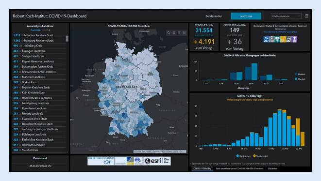
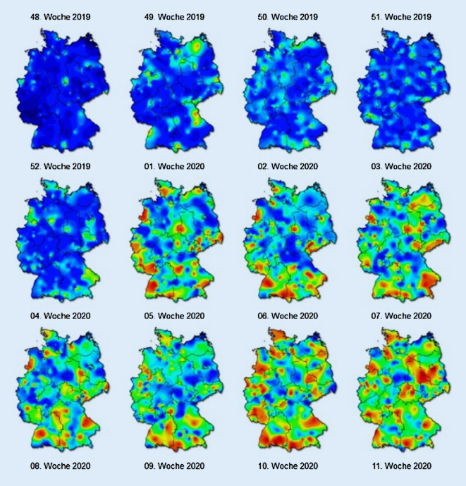
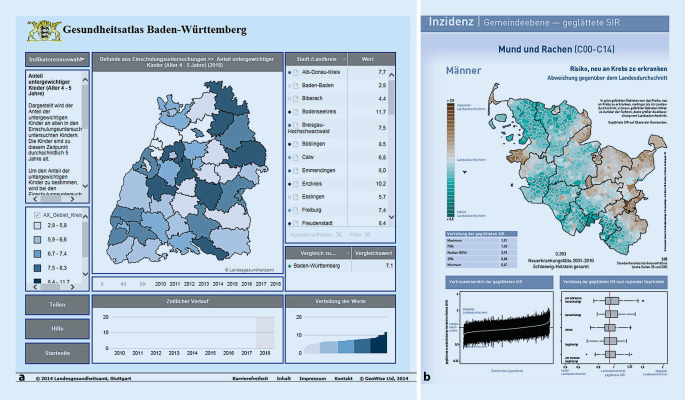
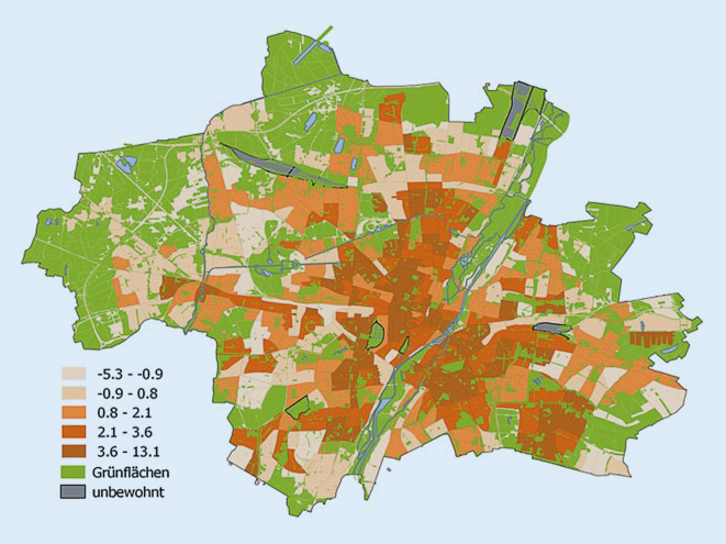
Es wird gezeigt, dass auf Bundesebene geografische Methoden z. B. in der Surveillance angewendet werden; auf Länderebene gibt es z. B. Gesundheitsatlanten und auf der Kommunalebene verschiedene geografische Analysen. Die methodische Spannweite reicht von einfacheren Kartendarstellungen auf unterschiedlichen Aggregationsebenen bis hin zu komplexeren Verfahren wie raum-zeitlichen Darstellungen und räumlichen Glättungsverfahren.
Fehlender Datenzugang oder datenschutzrechtliche Aspekte behindern noch häufig die Verbindung mit weiteren Datenquellen oder kleinräumigere Darstellungen. Vor allem ein besserer Zugang zu Daten auf kleinräumiger Ebene könnte die GBE aber erheblich erleichtern. Die Bevölkerung und Entscheidungsträger könnten dadurch noch umfassender informiert und folglich die Gesundheit und die gesundheitliche Versorgung der Bevölkerung verbessert werden.
Keywords: GIS; Geographic methods; Gesundheitsatlas; Health monitoring; Regional variation.
Similar articles
-
[What potential do geographic information systems have for population-wide health monitoring in Germany? : Perspectives and challenges for the health monitoring of the Robert Koch Institute].Bundesgesundheitsblatt Gesundheitsforschung Gesundheitsschutz. 2017 Dec;60(12):1440-1452. doi: 10.1007/s00103-017-2652-4. Bundesgesundheitsblatt Gesundheitsforschung Gesundheitsschutz. 2017. PMID: 29075811 Review. German.
-
Easier surveillance of climate-related health vulnerabilities through a Web-based spatial OLAP application.Int J Health Geogr. 2009 Apr 3;8:18. doi: 10.1186/1476-072X-8-18. Int J Health Geogr. 2009. PMID: 19344512 Free PMC article.
-
[Use of geographic information systems in public health].Med Parazitol (Mosk). 2014 Jul-Sep;(3):46-51. Med Parazitol (Mosk). 2014. PMID: 25286553 Russian.
-
Assessment and statistical modeling of the relationship between remotely sensed aerosol optical depth and PM2.5 in the eastern United States.Res Rep Health Eff Inst. 2012 May;(167):5-83; discussion 85-91. Res Rep Health Eff Inst. 2012. PMID: 22838153
-
Geographic information systems (GIS) for Health Promotion and Public Health: a review.Health Promot Pract. 2011 Jan;12(1):63-73. doi: 10.1177/1524839909334624. Epub 2009 Jun 22. Health Promot Pract. 2011. PMID: 19546198 Review.
Cited by
-
A review of GIS methodologies to analyze the dynamics of COVID-19 in the second half of 2020.Trans GIS. 2021 Oct;25(5):2191-2239. doi: 10.1111/tgis.12792. Epub 2021 Jul 11. Trans GIS. 2021. PMID: 34512103 Free PMC article. Review.
-
Subjective walkability perceived by children and adolescents living in urban environments: A study protocol for participatory methods and scale development in the WALKI-MUC project.PLoS One. 2024 Mar 4;19(3):e0299208. doi: 10.1371/journal.pone.0299208. eCollection 2024. PLoS One. 2024. PMID: 38437205 Free PMC article.
-
Utilization of health-related data in the regional context for health service planning in the Federal State of Brandenburg, Germany-a qualitative study.Res Health Serv Reg. 2024 Sep 25;3(1):14. doi: 10.1007/s43999-024-00050-0. Res Health Serv Reg. 2024. PMID: 39317799 Free PMC article.
References
-
- Jacob R, Michels H. Regionale und kommunale Gesundheitsberichterstattung. Bundesgesundheitsblatt Gesundheitsforschung Gesundheitsschutz. 2000;43:615–623. doi: 10.1007/s001030070021. - DOI
-
- Trojan A, Ziese T (2015) Gesundheitsberichterstattung. In: Bundeszentrale für gesundheitliche Aufklärung. Leitbegriffe der Gesundheitsförderung und Prävention. https://www.leitbegriffe.bzga.de/alphabetisches-verzeichnis/gesundheitsb.... Zugegriffen: 24. Juli 2020
-
- Kistemann T, Schweikart J. Von der Krankheitsökologie zur Geographie der Gesundheit. Geogr Rundsch. 2010;62(7–8):4–10.
-
- Kistemann T, Schweikart J. Erkenntnisgeswinn einer räumlichen Betrachtung von Gesundheit. In: Augustin J, Koller D, editors. Geografie der Gesundheit. Die Räumliche Dimension von Epidemiologie und Versorgung. Bern: Hogrefe; 2016. pp. 15–44.
Publication types
MeSH terms
LinkOut - more resources
Full Text Sources
