

Genetic Structure of Invasive Baby's Breath (Gypsophila paniculata L.) Populations in a Michigan Dune System
- PMID: 32878034
- PMCID: PMC7570141
- DOI: 10.3390/plants9091123
Genetic Structure of Invasive Baby's Breath (Gypsophila paniculata L.) Populations in a Michigan Dune System
Abstract
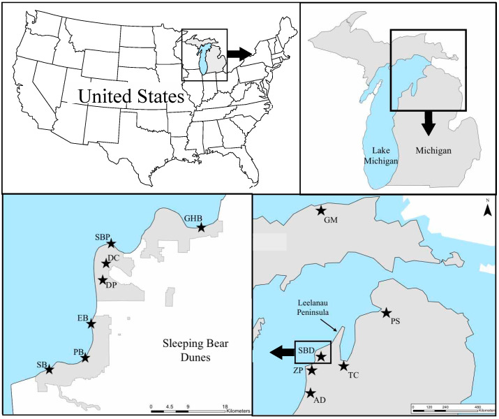
Coastal sand dunes are dynamic ecosystems with elevated levels of disturbance and are highly susceptible to plant invasions. One invasive plant that is of concern to the Great Lakes system is Gypsophila paniculata L. (perennial baby's breath). The presence of G. paniculata negatively impacts native species and has the potential to alter ecosystem dynamics. Our research goals were to (1) estimate the genetic structure of invasive G. paniculata along the Michigan dune system and (2) identify landscape features that influence gene flow in this area. We analyzed 12 populations at 14 nuclear and two chloroplast microsatellite loci. We found strong genetic structure among populations (global FST = 0.228), and pairwise comparisons among all populations yielded significant FST values. Results from clustering analysis via STRUCTURE and discriminant analysis of principal components (DAPC) suggest two main genetic clusters that are separated by the Leelanau Peninsula, and this is supported by the distribution of chloroplast haplotypes. Land cover and topography better explained pairwise genetic distances than geographic distance alone, suggesting that these factors influence the genetic distribution of populations within the dunes system. Together, these data aid in our understanding of how invasive populations move through the dune landscape, providing valuable information for managing the spread of this species.
Keywords: coastal sand dunes; genetic diversity; invasive species; landscape genetics; population structure.
Conflict of interest statement
The authors declare no conflict of interest.
Figures


Similar articles
-
Microsatellite primer development for the invasive perennial herb Gypsophila paniculata (Caryophyllaceae).Appl Plant Sci. 2018 Dec 11;6(12):e01203. doi: 10.1002/aps3.1203. eCollection 2018 Dec. Appl Plant Sci. 2018. PMID: 30598861 Free PMC article.
-
Identification and characterization of Gypsophila paniculata color morphs in Sleeping Bear Dunes National Lakeshore, MI, USA.PeerJ. 2019 Jun 17;7:e7100. doi: 10.7717/peerj.7100. eCollection 2019. PeerJ. 2019. PMID: 31245177 Free PMC article.
-
Examining the molecular mechanisms contributing to the success of an invasive species across different ecosystems.Ecol Evol. 2020 Aug 31;10(18):10254-10270. doi: 10.1002/ece3.6688. eCollection 2020 Sep. Ecol Evol. 2020. PMID: 33005380 Free PMC article.
-
[Research progress on plant diversity conservation in sand dune areas].Ying Yong Sheng Tai Xue Bao. 2008 Jan;19(1):183-90. Ying Yong Sheng Tai Xue Bao. 2008. PMID: 18419093 Review. Chinese.
-
Potential of Microbial Diversity of Coastal Sand Dunes: Need for Exploration in Odisha Coast of India.ScientificWorldJournal. 2019 Jul 14;2019:2758501. doi: 10.1155/2019/2758501. eCollection 2019. ScientificWorldJournal. 2019. PMID: 31391794 Free PMC article. Review.
Cited by
-
Using species distribution models to locate the potential cradles of the allopolyploid Gypsophila bermejoi G. López (Caryophyllaceae).PLoS One. 2020 May 19;15(5):e0232736. doi: 10.1371/journal.pone.0232736. eCollection 2020. PLoS One. 2020. PMID: 32428047 Free PMC article.
References
-
- Arbogast A.F., Loope W.L. Maximum-limiting ages of Lake Michigan coastal dunes: Their correlation with Holocene lake level history. J. Great Lakes Res. 1999;25:372–382. doi: 10.1016/S0380-1330(99)70746-X. - DOI
-
- Everard M., Jones L., Watts B. Have we neglected the societal importance of sand dunes? An ecosystem services perspective. Aquat. Conserv. 2010;20:476–487. doi: 10.1002/aqc.1114. - DOI
-
- Blumer B.E., Arbogast A.F., Forman S.L. The OSL chronology of eolian sand deposition in a perched dune field along the northwestern shore of Lower Michigan. Quat. Res. 2012;77:445–455. doi: 10.1016/j.yqres.2012.01.006. - DOI
-
- Cowles H.C. The ecological relations of the vegetation on the sand dunes of Lake Michigan. Part I.—Geographical relations of the dune floras. Bot. Gaz. 1899;27:95–117. doi: 10.1086/327796. - DOI
-
- Olson J.S. Rates of succession and soil changes on southern Lake Michigan sand dunes. Bot. Gaz. 1958 doi: 10.1086/335973. - DOI
Grants and funding
LinkOut - more resources
Full Text Sources
Miscellaneous
