

Understanding of Contemporary Regional Sea-Level Change and the Implications for the Future
- PMID: 32879921
- PMCID: PMC7375165
- DOI: 10.1029/2019RG000672
Understanding of Contemporary Regional Sea-Level Change and the Implications for the Future
Abstract
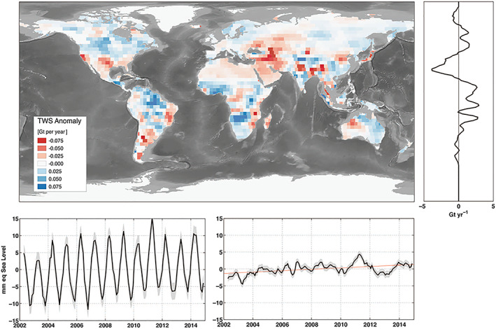
Global sea level provides an important indicator of the state of the warming climate, but changes in regional sea level are most relevant for coastal communities around the world. With improvements to the sea-level observing system, the knowledge of regional sea-level change has advanced dramatically in recent years. Satellite measurements coupled with in situ observations have allowed for comprehensive study and improved understanding of the diverse set of drivers that lead to variations in sea level in space and time. Despite the advances, gaps in the understanding of contemporary sea-level change remain and inhibit the ability to predict how the relevant processes may lead to future change. These gaps arise in part due to the complexity of the linkages between the drivers of sea-level change. Here we review the individual processes which lead to sea-level change and then describe how they combine and vary regionally. The intent of the paper is to provide an overview of the current state of understanding of the processes that cause regional sea-level change and to identify and discuss limitations and uncertainty in our understanding of these processes. Areas where the lack of understanding or gaps in knowledge inhibit the ability to provide the needed information for comprehensive planning efforts are of particular focus. Finally, a goal of this paper is to highlight the role of the expanded sea-level observation network-particularly as related to satellite observations-in the improved scientific understanding of the contributors to regional sea-level change.
Keywords: remote sensing; satellite observations; sea level.
©2020. American Geophysical Union. All Rights Reserved.
Conflict of interest statement
The authors declare no competing interests.
Figures
References
-
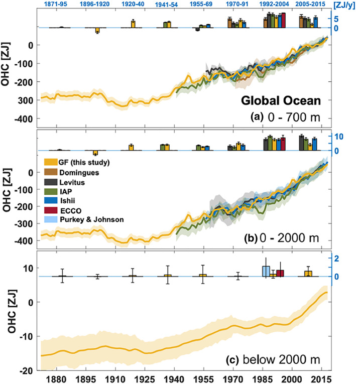
- Abraham, J. P. , Baringer, M. , Bindoff, N. L. , Boyer, T. , Cheng, L. J. , Church, J. A. , Conroy, J. L. , Domingues, C. M. , Fasullo, J. T. , Gilson, J. , Goni, G. , Good, S. A. , Gorman, J. M. , Gouretski, V. , Ishii, M. , Johnson, G. C. , Kizu, S. , Lyman, J. M. , Macdonald, A. M. , Minkowycz, W. J. , Moffitt, S. E. , Palmer, M. D. , Piola, A. R. , Reseghetti, F. , Schuckmann, K. , Trenberth, K. E. , Velicogna, I. , & Willis, J. K. (2013). A review of global ocean temperature observations: Implications for ocean heat content estimates and climate change. Reviews of Geophysics, 51, 450–483. 10.1002/rog.20022 - DOI
-
- Adhikari, S. , Ivins, E. R. , & Larour, E. (2016). ISSM‐SESAW v1. 0: Mesh‐based computation of gravitationally consistent sea‐level and geodetic signatures caused by cryosphere and climate driven mass change. Geoscientific Model Development, 9(3), 1087–1109. 10.5194/gmd-9-1087-2016 - DOI
-
- Adhikari, S. , Ivins, E. R. , Larour, E. , Seroussi, H. , Morlighem, M. , & Nowicki, S. (2014). Future Antarctic bed topography and its implications for ice sheet dynamics. Solid Earth, 5(1), 569–584. 10.5194/se-5-569-2014 - DOI
-
- Adhikari, S. , & Marshall, S. J. (2013). Influence of high‐order mechanics on simulation of glacier response to climate change: Insights from Haig Glacier, Canadian Rocky Mountains. The Cryosphere, 7(1), 1527–1541. 10.5194/tc-7-1527-2013 - DOI