

Effect of land cover composition and building configuration on land surface temperature in an urban-sprawl city, case study in Bangkok Metropolitan Area, Thailand
- PMID: 32904275
- PMCID: PMC7452575
- DOI: 10.1016/j.heliyon.2020.e04485
Effect of land cover composition and building configuration on land surface temperature in an urban-sprawl city, case study in Bangkok Metropolitan Area, Thailand
Abstract
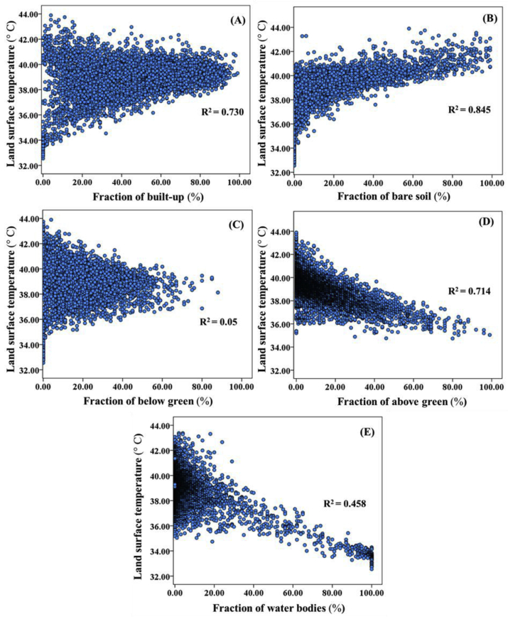
The Bangkok Metropolitan Area is an example of urban sprawl that has undergone rapid expansion and major changes in urban composition and building configuration. This city is now faced with the urban heat island phenomenon. Initial observations of land surface temperature (LST) in recent years have indicated that LST has tended to increase in both urban and suburban areas. The purposes of this study were to: (1) assess different land cover types and combinations of land cover composition along an LST gradient, and (2) investigate effect of building configuration types on the LST in densely urban areas. We analyzed the urban composition variation of 4,960 land cover samples using a 500 m × 500 m grid and configuration metrics in spatial patterns from Landsat 8 data and a high-resolution database of buildings obtained from GIS data of the Bangkok Metropolitan Area. The results indicated that the fraction of land cover composition was strongly related to LST. Our results suggested that LST can be effectively mitigated by using below green (shrubs, grasses, and yards), above green (trees, orchards, mangroves, and perennial plants) and water land cover. By increasing tree canopy to around 20%, water body to around 30% or green yard/shrub to around 40% of the built-up areas, it is possible to reduce LST significantly. Urban configurations (edge density, patch density, large patch, mean patch size, building height, compactness of building, building type, and building use) affecting on LST were studied. Increased edge density, patch density of buildings, and building height caused reductions in LST. Distribution of LST patterns can be significantly related with urban composition or land configuration features. The results of this study can increase understanding of the interaction between urban composition and configuration metrics. Moreover, our findings may be useful in the mitigation of the impact of LST in urban-sprawl cities.
Keywords: Bangkok; Earth sciences; Environmental science; Land surface temperature (LST); Materials science; Urban composition; Urban configuration; Urban heat island.
© 2020 The Author(s).
Figures


References
-
- Alobaydi D., Bakarman M.A., Obeidat B. The impact of urban form configuration on the urban heat island: the case study of Baghdad, Iraq. International Conference on Sustainable Design, Engineering and Construction. 2016;145:820–882.
-
- Anongrak N. Chiang Mai University; Chiang Mai: 2010. General Soil.
-
- Arnfield A.J. Review two decades of urban climate research: a review of turbulence, exchanges of energy and water, and the urban heat island. Int. J. Climatol. 2003;23:1–26.
-
- Balogun I.A., Daramola M.T. The outdoor thermal comfort assessment of different urban configurations within Akure City, Nigeria. Urban Climate. 2019;29:1–13.
-
- Ben-Dor E., Saaroni H. Airborne video thermal radiometry as a tool for monitoring microscale structures of the urban heat island. Int. J. Rem. Sens. 1997;18(4):3039–3053.
LinkOut - more resources
Full Text Sources
