

Covid-19 and rural landscape: The case of Italy
- PMID: 32994653
- PMCID: PMC7515565
- DOI: 10.1016/j.landurbplan.2020.103955
Covid-19 and rural landscape: The case of Italy
Abstract
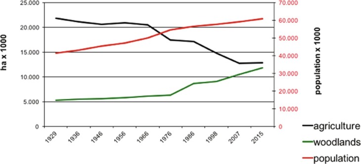
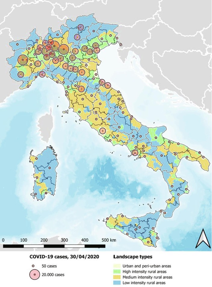
Throughout the covid-19 emergency, health authorities have presented contagion data divided by administrative regions with no reference to the type of landscape, environment or development model. This study has been conducted to understand whether there is a correlation between the number of infections and the different rural landscapes of the country. Italy's rural landscape can be classified in four types, according to the intensity of energy inputs used in the agricultural process, socioeconomic and environmental features. Type A includes areas of periurban agriculture surrounding the metropolitan cities, type B areas of intensive agriculture with high concentration of agroindustry, type C hilly areas with highly diversified agriculture and valuable landscape, and type D high hills and mountains with forests and protected areas. Areas A and B are located in the plains, covering 21% of the territory and accounting for 57% of the population. They produce most of the added value, consume high levels of energy and represent the main source of pollution. Areas C and D cover 79% of the territory and 43% of the population. We find that provinces with 10% more type C and D areas exhibit on average 10% fewer cases of contagion. The result is statistically significant, after controlling for demographic, economic and environmental characteristics of the provinces. The pollution produced in more energy-intensive landscape has triggered an intense debate of how to ensure the economic competitiveness of Italian agriculture, without compromising environmental integrity or public health. Our findings speak to this debate, by suggesting that planning for more rural territory with lower energy inputs may come with the added benefit of new development opportunities and decreasing the exposure of the population to covid-19. Cost benefit-analyses should take into account that policies aimed at revitalizing more rural areas may reduce the economic impact of covid-19 and of potential future pandemics.
© 2020 The Authors.
Figures

References
-
- Agnoletti M. Italian historical rural landscapes; dynamics, data analysis and research findings. In: Agnoletti M., editor. The Italian Historical Rural Landscape. Cultural values for the environment and rural development. Springer Verlag, Dordrecht; 2013. pp. 3–88.
-
- Agnoletti M. Rural landscape, nature conservation and culture: Some notes on research trends and management approaches from a (southern)European perspective. Landscape and Urban Planning. 2014;126:66–73.
-
- Agnoletti M., Errico A., Santoro A., Dani A., Preti F. Terraced landscapes and hydrogeological risk. Effects of land abandonment in Cinque Terre (Italy) during severe rainfall events. Sustainability. 2019;11:235.
-
- Antrop M. The concept of traditional landscapes as a base for landscape evaluation and planning: The example of Flanders Region. Landscape and Urban Planning. 1997;38:105–117.
LinkOut - more resources
Full Text Sources