

Addressing the need for improved land cover map products for policy support
- PMID: 33013195
- PMCID: PMC7521452
- DOI: 10.1016/j.envsci.2020.04.005
Addressing the need for improved land cover map products for policy support
Abstract
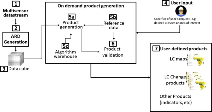
The continued increase of anthropogenic pressure on the Earth's ecosystems is degrading the natural environment and then decreasing the services it provides to humans. The type, quantity, and quality of many of those services are directly connected to land cover, yet competing demands for land continue to drive rapid land cover change, affecting ecosystem services. Accurate and updated land cover information is thus more important than ever, however, despite its importance, the needs of many users remain only partially attended. A key underlying reason for this is that user needs vary widely, since most current products - and there are many available - are produced for a specific type of end user, for example the climate modelling community. With this in mind we focus on the need for flexible, automated processing approaches that support on-demand, customized land cover products at various scales. Although land cover processing systems are gradually evolving in this direction there is much more to do and several important challenges must be addressed, including high quality reference data for training and validation and even better access to satellite data. Here, we 1) present a generic system architecture that we suggest land cover production systems evolve towards, 2) discuss the challenges involved, and 3) propose a step forward. Flexible systems that can generate on-demand products that match users' specific needs would fundamentally change the relationship between users and land cover products - requiring more government support to make these systems a reality.
Keywords: Applications; Earth observation; Ecosystem services; Land cover; Reference data; Remote sensing.
© 2020 The Authors.
Conflict of interest statement
The authors declare that they have no known competing financial interests or personal relationships that could have appeared to influence the work reported in this paper.
Figures
References
-
- Ariza-Porras C., Bravo G., Villamizar M., Moreno A., Castro H., Galindo G., Cabera E., Valbuena S., Lozano P. CDCol: a geoscience data cube that meets Colombian needs. In: Solano A., Ordoñez H., editors. vol. 735. Springer International Publishing; Cham: 2017. pp. 87–99. (Advances in Computing).
-
- Belward A.S., Skøien J.O. Who launched what, when and why; trends in global land-cover observation capacity from civilian earth observation satellites. ISPRS J. Photogramm. Remote Sens. 2015;103:115–128. doi: 10.1016/j.isprsjprs.2014.03.009. - DOI
-
- Bontemps S., Herold M., Kooistra L., van Groenestijn A., Hartley A., Arino O., Moreau I., Defourny P. Revisiting land cover observation to address the needs of the climate modeling community. Biogeosciences. 2012;9:2145–2157. doi: 10.5194/bg-9-2145-2012. - DOI
-
- Brown J.F., Tollerud H.J., Barber C.P., Zhou Q., Dwyer J.L., Vogelmann J.E., Loveland T.R., Woodcock C.E., Stehman S.V., Zhu Z., Pengra B.W., Smith K., Horton J.A., Xian G., Auch R.F., Sohl T.L., Sayler K.L., Gallant A.L., Zelenak D., Reker R.R., Rover J. Lessons learned implementing an operational continuous United States national land change monitoring capability: the Land Change Monitoring, Assessment, and Projection (LCMAP) approach. Remote Sens. Environ. 2020;238:111356. doi: 10.1016/j.rse.2019.111356. - DOI
-
- Buchanan G., Beresford A.E., Hebblewhite M., Escobedo F., De Klerk H., Donald P.F., Escribano P., Koh L.P., Martinez-Lopez J., Pettorelli N., Skidmore A.K., Szantoi Z., Tabor K., Wegmann M., Wich S.A. Free satellite data key to conservation. Science. 2018;361:139–140. doi: 10.1126/science.aau2650. - DOI - PubMed
LinkOut - more resources
Full Text Sources