. 2020 Oct 12;11(1):5135.
doi: 10.1038/s41467-020-19000-8.

Andean drought and glacial retreat tied to Greenland warming during the last glacial period

Affiliations

Andean drought and glacial retreat tied to Greenland warming during the last glacial period

Arielle Woods et al. Nat Commun. .

Abstract

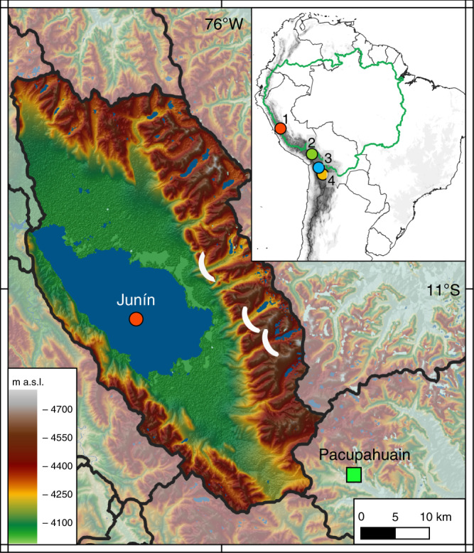
Abrupt warming events recorded in Greenland ice cores known as Dansgaard-Oeschger (DO) interstadials are linked to changes in tropical circulation during the last glacial cycle. Corresponding variations in South American summer monsoon (SASM) strength are documented, most commonly, in isotopic records from speleothems, but less is known about how these changes affected precipitation and Andean glacier mass balance. Here we present a sediment record spanning the last ~50 ka from Lake Junín (Peru) in the tropical Andes that has sufficient chronologic precision to document abrupt climatic events on a centennial-millennial time scale. DO events involved the near-complete disappearance of glaciers below 4700 masl in the eastern Andean cordillera and major reductions in the level of Peru's second largest lake. Our results reveal the magnitude of the hydroclimatic disruptions in the highest reaches of the Amazon Basin that were caused by a weakening of the SASM during abrupt arctic warming. Accentuated warming in the Arctic could lead to significant reductions in the precipitation-evaporation balance of the southern tropical Andes with deleterious effects on this densely populated region of South America.


Conflict of interest statement

The authors declare no competing interests.

Figures

Fig. 1
Fig. 1. Location of the Lake Junín (4100 masl) drainage basin and Pacupahuain cave in central Peru.
White ellipses in valleys east of Lake Junín indicate the mapped down valley extent of glaciers during the local Last Glacial Maximum. Inset map: green line indicates the Amazon drainage basin, and circles indicate Andean records discussed in the text: 1. Junín, 2. Lake Titicaca, 3. Paleolake Tauca,, 4. Salar de Uyuni.
Fig. 2
Fig. 2. Physical and geochemical sediment properties from the Junín drill core.
The similar XRF profiles of a Ti and b Si indicate both elements primarily represent clastic inputs, with slight differences attributable to different bedrock mineralogy and grain size. c Siliciclastic sediment flux (log scale). d Total organic carbon (TOC). e Dry bulk density. f Bacon age-depth model of 79 AMS radiocarbon ages on terrestrial macrofossils; error bars denote 95% probability range for calibrated ages. Ages excluded from the age model are listed in the supplemental. Gray vertical bars show the distribution of peat layers.
Fig. 3
Fig. 3. Comparison of regional and global proxy paleoclimatic records.
a Junín glaciation (Ti from Fig. 2a). b Junín low stands (peat layers). c Pacupahuain speleothem δ18O. d El Condor speleothem δ18O. e Amazon Discharge. f Atlantic Meridional Overturning Circulation (AMOC) strength (dark blue curve is Pa/Th data reported in (1)), and the light blue curve is a compilation of previously reported Pa/Th records as presented in (1). g Relative sea level. h WAIS Divide ice core δ18O. i NGRIP ice core δ18O,. Vertical gray boxes denote the Younger Dryas and Heinrich stadials H1–H5, and numbered vertical lines are Dansgaard–Oeschger (DO) warming events 2–13.

References

    1. Henry LG, et al. North Atlantic ocean circulation and abrupt climate change during the last glaciation. Science. 2016;353:470–474. doi: 10.1126/science.aaf5529. - DOI - PubMed
    1. McGee D, et al. Hemispherically asymmetric trade wind changes as signatures of past ITCZ shifts. Quat. Sci. Rev. 2018;180:214–228. doi: 10.1016/j.quascirev.2017.11.020. - DOI
    1. Portilho-Ramos RC, et al. Coupling of equatorial Atlantic surface stratification to glacial shifts in the tropical rainbelt. Sci. Rep. 2017;7:1561. doi: 10.1038/s41598-017-01629-z. - DOI - PMC - PubMed
    1. Arz HW, Pätzold J, Wefer G. Correlated millennial-scale changes in surface hydrography and terrigenous sediment yield inferred from last-glacial marine deposits off Northeastern Brazil. Quat. res. 1998;50:157–166. doi: 10.1006/qres.1998.1992. - DOI
    1. Kanner LC, Burns SJ, Cheng H, Edwards RL. High-latitude forcing of the South American summer monsoon during the last glacial. Science. 2012;335:570–573. doi: 10.1126/science.1213397. - DOI - PubMed

Publication types