. 2020 Oct 15;10(1):17497.
doi: 10.1038/s41598-020-74270-y.

Coexisting with sharks: a novel, socially acceptable and non-lethal shark mitigation approach

Affiliations

Coexisting with sharks: a novel, socially acceptable and non-lethal shark mitigation approach

Kye R Adams et al. Sci Rep. .

Abstract

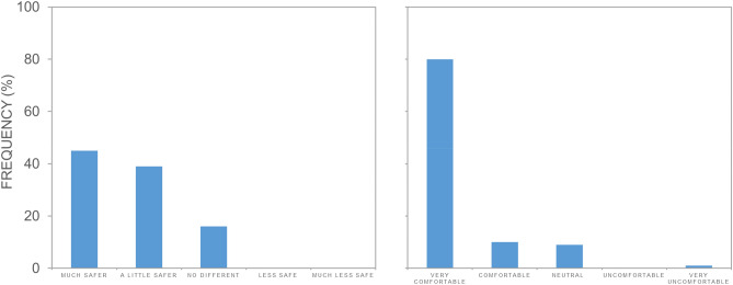
Conflict between humans and large predators is a longstanding challenge that can present negative consequences for humans and wildlife. Sharks have a global distribution and are considered to pose a potential threat to humans; concurrently many shark species are themselves threatened. Developing strategies for coexistence between humans and this keystone group is imperative. We assess blimp surveillance as a technique to simply and effectively reduce shark encounters at ocean beaches and determine the social acceptance of this technique as compared to an established mitigation strategy-shark meshing. We demonstrate the suitability of blimps for risk mitigation, with detection probabilities of shark analogues by professional lifeguards of 0.93 in ideal swimming conditions. Social surveys indicate strong social acceptance of blimps and preference for non-lethal shark mitigation. We show that continuous aerial surveillance can provide a measurable reduction in risk from sharks, improving beach safety and facilitating coexistence between people and wildlife.


Conflict of interest statement

The authors declare no competing interests.

Figures

Figure 1
Figure 1
The blimp with camera module attached (left) and the view of Surf Beach from the blimp deployed at 70 m height.
Figure 2
Figure 2
Shark analogue detection probabilities in (a) sunny (n = 29 analogue deployments over 5 days) and (b) cloudy (n = 22 analogue deployments over 5 days) conditions at Surf Beach in Kiama, NSW, Australia. Maps were created using ArcGIS Pro version 2.0.1 by Esri (www.esri.com).
Figure 3
Figure 3
The probability of detection of 51 shark analogue deployments determined in trials by 20 lifeguards (± SE) in a double blind trial based on water depth (shallow: 2–3 m and deep: 4–5 m) versus cloud cover (sunny versus cloudy) and wind speed. Letters denote significant differences as determined by post hoc Tukeys multiple comparisons of means.
Figure 4
Figure 4
(a) Shark analogue detection sensitivity and (b) the proportion of false alarms of 20 professional lifeguards in Sunny and Cloudy conditions. Black point indicates the group mean. Grey lines join each individual lifeguard across the different weather conditions. A higher d prime indicates the easier discrimination of shark analogues from background noise (e.g. drift algae).
Figure 5
Figure 5
Frequency histogram showing responses to two related survey questions: (a) ‘Does the blimp give you a sense of safety from beach hazards?’ and (b) ‘Do you feel comfortable with the blimp at the beach?’.
Figure 6
Figure 6
Frequency histogram showing responses to the survey question: ‘In general, what approaches would you like to see for keeping people safe from potential threats from sharks? (Choose as many options as you like)’ where A is ‘Spotting or detecting sharks, through methods that do not harm them’; B is ‘Relying on individuals taking responsibility for their own actions’; C is ‘Relying on personal deterrent devices, like electrical shields’; D is ‘Catching sharks and taking them off-shore, even if there is a risk of harming them’; E is ‘Catching and killing sharks’; and F is ‘Other’.
Figure 7
Figure 7
Surf Beach, Kiama is located on the south coast of NSW Australia. The beach is typical of a sandy coastal embayment and is enclosed by two fringing rocky reef headlands. Swimmers and surfers are frequent users of the bay over summer, with usage regulated by lifeguards. Swimmers are encouraged to swim within a flagged area where surfers are prohibited. Maps were created using ArcGIS Pro version 2.0.1 by Esri (www.esri.com).

References

    1. Thirgood S, Woodroffe R, Rabinowitz A. The impact of human–wildlife conflict on human lives and livelihoods. In: Rabinowitz A, Woodroffe R, Thirgood S, editors. People and Wildlife, Conflict or Co-existence? Conservation Biology. Cambridge: Cambridge University Press; 2005. pp. 13–26.
    1. Nyhus PJ. Human-wildlife conflict and coexistence. Annu. Rev. Environ. Resour. 2016;41:143–171. doi: 10.1146/annurev-environ-110615-085634. - DOI
    1. Curtis T, et al. Responding to the risk of white shark attack: updated statistics, prevention, control methods, and recommendations. In: Domeier ML, et al., editors. Global Perspectives on the Biology and Life History of the White SharkEdition: First edition, pp 477–509. Boca Raton, FL: CRC Press Taylor and Francis; 2012.
    1. Sillero-Zubiri C, Hoffmann M, Macdonald DW, editors. Canids: Foxes, Wolves, Jackals, and Dogs: Status Survey and Conservation Action Plan. Cambridge: Gland; 2004. p. 430.
    1. Soulé M. The, “New Conservation”. Conserv. Biol. 2013;27:895–897. doi: 10.1111/cobi.12147. - DOI - PubMed

Publication types