

Multiscale consensus habitat modeling for landscape level conservation prioritization
- PMID: 33082467
- PMCID: PMC7576151
- DOI: 10.1038/s41598-020-74716-3
Multiscale consensus habitat modeling for landscape level conservation prioritization
Abstract
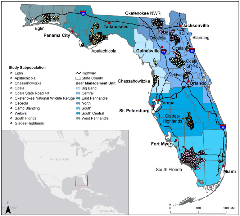
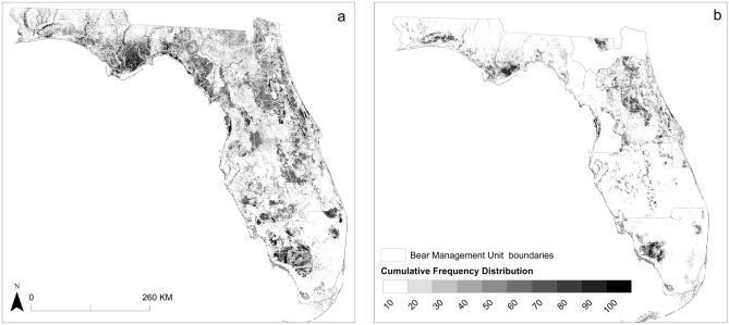
Globally, wide-ranging carnivore populations are imperiled due to human-caused habitat fragmentation. Where populations are fragmented, habitat quantification is often the first step in conservation. Presence-only species distribution models can provide robust results when proper scales and data are considered. We aimed to identify habitat for a fragmented carnivore population at two scales and aid conservation prioritization by identifying potential future habitat fragmentation. We used location data and environmental variables to develop a consensus model using Maxent and Mahalanobis distance to identify black bear (Ursus americanus floridanus) habitat across Florida, USA. We compared areas of habitat to areas of predicted sea level rise, development, and protected areas. Local-scale models performed better than state-scale models. We identified 23,798 km2 of habitat at the local-scale and 45,703 km2 at the state-scale. Approximately 10% of state- and 14% of local-scale habitat may be inundated by 2100, 16% of state- and 7% of local-scale habitat may be developed, and 54% of state- and 15% of local-scale habitat is unprotected. Results suggest habitat is at risk of fragmentation. Lack of focused conservation and connectivity among bear subpopulations could further fragmentation, and ultimately threaten population stability as seen in other fragmented carnivore populations globally.
Conflict of interest statement
The authors declare no competing interests.
Figures

References
-
- Smeraldo S, et al. Modelling risks posed by wind turbines and power lines to soaring birds: the black stork (Ciconia nigra) in Italy as a case study. Biodivers. Conserv. 2020;29:1959–1976. doi: 10.1007/s10531-020-01961-3. - DOI
-
- Sodhi NS, Lee TM, Koh LP, Brook BW. A meta-analysis of the impact of anthropogenic forest disturbance on Southeast Asia’s biotas. Biotropica. 2009;41:103–109. doi: 10.1111/j.1744-7429.2008.00460.x. - DOI
MeSH terms
LinkOut - more resources
Full Text Sources
