

Prediction of grass biomass from satellite imagery in Somali regional state, eastern Ethiopia
- PMID: 33102871
- PMCID: PMC7569346
- DOI: 10.1016/j.heliyon.2020.e05272
Prediction of grass biomass from satellite imagery in Somali regional state, eastern Ethiopia
Abstract
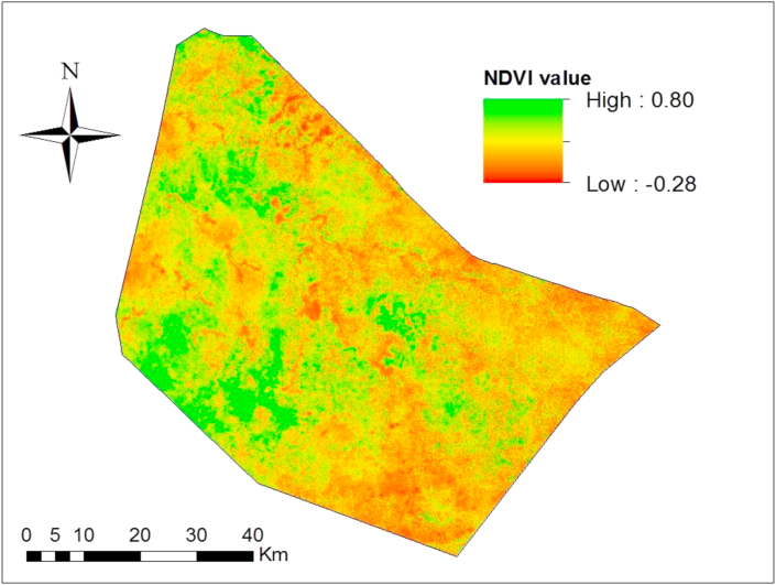
The drought-prone Ethiopian Somali region has a long history of pastoralism (livestock grazing), which is a major source of livelihoods. However, it suffers from poor rangeland management and a lack of research and information. The objectives of this study were to develop a method for forecasting forage biomass and to quantify production of and spatial variation in forage from satellite imagery. We downloaded Sentinel-2 images and processed spectral information in the blue, red, and near-infrared bands, and calculated the Normalized Difference Vegetation Index (NDVI) and Enhanced Vegetation Index (EVI). Combining ground sampling (on 55 plots) with remote sensing data, we developed a forage forecasting model for the area. Forage (biomass) was significantly correlated with both EVI (R 2 = 0.87; P < 0.001) and NDVI (R 2 = 0.81; P < 0.001). Both gave good predictions of forage biomass in the district. We estimated the annual biomass in each grassland pixel at the peak of the growing season. Models based on each index revealed close estimates: NDVI indicated an average of 0.76 t/ha and a total of 38 772 t/year; EVI indicated an average of 0.78 t/ha and a total of 39 792 t/year. The estimated rangeland biomass showed high spatial variability of 0.22-4.89 t/ha.year. For future rangeland management in the area, the proposed approach and models can be used to estimate available forage biomass from satellite imagery in the middle of the grass growing season (2 months after the rains start), before the grass matures and is harvested.
Keywords: Agriculture; Applied ecology; Biomass; Drought-prone; EVI; Ecology; Ecosystem change; Environmental analysis; IPADS; Jigjiga university; NDVI; Natural resource management; Rangeland; Remote sensing; Sustainable development.
© 2020 Published by Elsevier Ltd.
Figures


References
-
- Abbas S., Saleem A., Sharif Z., Mirza S. Estimation of biomass and carrying capacity of scrub rangelands in ucchali wetland complex, soon valley. Biologia. 2012;58(1&2):93–100.
-
- Asresie A., Zemedu L. Contribution of livestock sector in Ethiopian economy: a review. Adv. Life Sci. Technol. 2015;29:79–90.
-
- Bat-Oyun S., Shinoda M., Cheng Y., Purevdorj Y. Effects of grazing and precipitation variability on vegetation dynamics in a Mongolian dry steppe. J. Plant Ecol. 2016;9:508–519.
-
- Beaudoin A., Le Toan T. Retrieval of forest biomass from SAR data. Int. J. Rem. Sens. 1994;15:2777–2796.
-
- BOFED (Bureau of Finance and Economic Development) 2012. Somali Region, Jijiga, Ethiopia.
LinkOut - more resources
Full Text Sources
