Haiti has more forest than previously reported: land change 2000-2015
- PMID: 33173614
- PMCID: PMC7594639
- DOI: 10.7717/peerj.9919
Haiti has more forest than previously reported: land change 2000-2015
Abstract
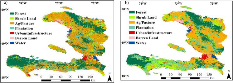
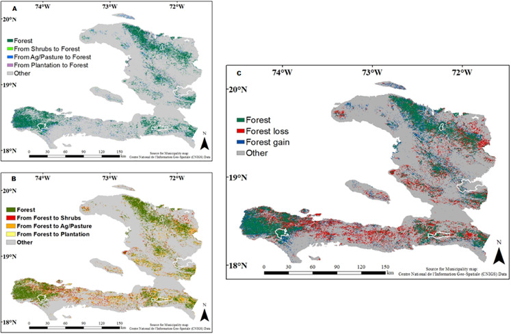
Estimates of forest cover have important political, conservation, and funding implications, but methods vary greatly. Haiti has often been cited as one of the most deforested countries in the world, yet estimates of forest cover range from <1% to 33%. Here, we analyze land change for seven land cover classes (forest, shrub land, agriculture/pasture, plantation, urban/infrastructure, barren land, and water) between 2000 and 2015 using Landsat imagery (30 m resolution) in the Google Earth Engine platform. Forest cover was estimated at 26% in 2000 and 21% in 2015. Although forest cover is declining in Haiti, our quantitative analysis resulted in considerably higher forest cover than what is usually reported by local and international institutions. Our results determined that areas of forest decline were mainly converted to shrubs and mixed agriculture/pasture. An important driver of forest loss and degradation could be the high demand for charcoal, which is the principal source of cooking fuel. Our results differ from other forest cover estimates and forest reports from national and international institutions, most likely due to differences in forest definition, data sources, spatial resolution, and methods. In the case of Haiti, this work demonstrates the need for clear and functional definitions and classification methods to accurately represent land use/cover change. Regardless of how forests are defined, forest cover in Haiti will continue to decline unless corrective actions are taken to protect remaining forest patches. This can serve as a warning of the destructive land use patterns and can help us target efforts for better planning, management, and conservation.
Keywords: Deforestation; Forest; Google Earth Engine; Haiti; Land use/cover; Landsat imagery.
© 2020 Pauleus and Aide.
Conflict of interest statement
The authors declare that they have no competing interests.
Figures
Similar articles
-
Spatiotemporal trends and drivers of forest cover change in Metekel Zone forest areas, Northwest Ethiopia.Environ Monit Assess. 2024 Nov 6;196(12):1170. doi: 10.1007/s10661-024-13294-7. Environ Monit Assess. 2024. PMID: 39503834 Free PMC article.
-
Development of deforestation and land cover database for Bhutan (1930-2014).Environ Monit Assess. 2016 Dec;188(12):658. doi: 10.1007/s10661-016-5676-6. Epub 2016 Nov 10. Environ Monit Assess. 2016. PMID: 27832432
-
Land-cover change in Cuba and implications for the area of distribution of a specialist's host-plant.PeerJ. 2024 Jun 25;12:e17563. doi: 10.7717/peerj.17563. eCollection 2024. PeerJ. 2024. PMID: 38948225 Free PMC article.
-
Impacts of Participatory Forest Management on Land Use/Land Cover of Adaba-Dodola Forest in South Eastern Ethiopia and its Implication to REDD+ Implementation.Environ Manage. 2025 Feb;75(2):341-355. doi: 10.1007/s00267-024-02083-0. Epub 2024 Nov 5. Environ Manage. 2025. PMID: 39499269
-
Multiscale land use impacts on water quality: Assessment, planning, and future perspectives in Brazil.J Environ Manage. 2020 Sep 15;270:110879. doi: 10.1016/j.jenvman.2020.110879. Epub 2020 Jun 12. J Environ Manage. 2020. PMID: 32721318 Review.
Cited by
-
Examining long-term natural vegetation dynamics in the Aral Sea Basin applying the linear spectral mixture model.PeerJ. 2021 Mar 2;9:e10747. doi: 10.7717/peerj.10747. eCollection 2021. PeerJ. 2021. PMID: 33717666 Free PMC article.
References
-
- Abdollahnejad A, Panagiotidis D, Surový P. Forest canopy density assessment using different approaches—review. Journal of Forest Science. 2017;63:107–116. doi: 10.17221/110/2016-JFS. - DOI
-
- Aide TM, Clark ML, Grau HR, López-Carr D, Levy MA, Redo D, Bonilla-Moheno M, Riner G, Andrade-Núñez MJ, Muñiz M. Deforestation and reforestation of Latin America and the Caribbean (2001–2010) Biotropica. 2013;45(2):262–271. doi: 10.1111/j.1744-7429.2012.00908.x. - DOI
-
- Álvarez-Berríos NL, Redo DJ, Aide TM, Clark ML, Grau R. Land change in the Greater Antilles between 2001 and 2010. Land. 2013;2(2):81–107. doi: 10.3390/land2020081. - DOI
-
- Barlow J, Gardner TA, Araujo IS, Avila-Pires TC, Bonaldo AB, Costa JE, Esposito MC, Ferreira LV, Hawes J, Hernandez MM, Hoogmoed MS, Leite RN, LoMan-Hung NF, Malcolm JR, Martins MB, Mestre LAM, Miranda-Santos R, Nunes-Gutjahr AL, Overal WL, Parry L, Peters SL, Ribeiro-Junior MA, Da Silva MNF, Da Silva Motta C, Peres CA. Quantifying the biodiversity value of tropical primary, secondary, and plantation forests. Proceedings of the National Academy of Sciences. 2007;104(47):18555–18560. doi: 10.1073/pnas.0703333104. - DOI - PMC - PubMed
LinkOut - more resources
Full Text Sources