

Predicting Aedes aegypti infestation using landscape and thermal features
- PMID: 33303912
- PMCID: PMC7729962
- DOI: 10.1038/s41598-020-78755-8
Predicting Aedes aegypti infestation using landscape and thermal features
Abstract
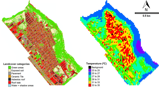
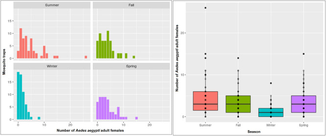
Identifying Aedes aegypti breeding hotspots in urban areas is crucial for the design of effective vector control strategies. Remote sensing techniques offer valuable tools for mapping habitat suitability. In this study, we evaluated the association between urban landscape, thermal features, and mosquito infestations. Entomological surveys were conducted between 2016 and 2019 in Vila Toninho, a neighborhood of São José do Rio Preto, São Paulo, Brazil, in which the numbers of adult female Ae. aegypti were recorded monthly and grouped by season for three years. We used data from 2016 to 2018 to build the model and data from summer of 2019 to validate it. WorldView-3 satellite images were used to extract land cover classes, and land surface temperature data were obtained using the Landsat-8 Thermal Infrared Sensor (TIRS). A multilevel negative binomial model was fitted to the data, which showed that the winter season has the greatest influence on decreases in mosquito abundance. Green areas and pavements were negatively associated, and a higher cover of asbestos roofs and exposed soil was positively associated with the presence of adult females. These features are related to socio-economic factors but also provide favorable breeding conditions for mosquitos. The application of remote sensing technologies has significant potential for optimizing vector control strategies, future mosquito suppression, and outbreak prediction.
Conflict of interest statement
The authors declare no competing interests.
Figures


Similar articles
-
Association between densities of adult and immature stages of Aedes aegypti mosquitoes in space and time: implications for vector surveillance.Parasit Vectors. 2022 Apr 19;15(1):133. doi: 10.1186/s13071-022-05244-4. Parasit Vectors. 2022. PMID: 35440010 Free PMC article.
-
Remote sensing for risk mapping of Aedes aegypti infestations: Is this a practical task?Acta Trop. 2020 May;205:105398. doi: 10.1016/j.actatropica.2020.105398. Epub 2020 Feb 14. Acta Trop. 2020. PMID: 32068030
-
High-resolution mapping of urban Aedes aegypti immature abundance through breeding site detection based on satellite and street view imagery.Sci Rep. 2024 Aug 6;14(1):18227. doi: 10.1038/s41598-024-67914-w. Sci Rep. 2024. PMID: 39107395 Free PMC article.
-
Assessment of the relationship between entomologic indicators of Aedes aegypti and the epidemic occurrence of dengue virus 3 in a susceptible population, São José do Rio Preto, São Paulo, Brazil.Acta Trop. 2015 Feb;142:167-77. doi: 10.1016/j.actatropica.2014.11.017. Epub 2014 Dec 4. Acta Trop. 2015. PMID: 25484110
-
São Paulo urban heat islands have a higher incidence of dengue than other urban areas.Braz J Infect Dis. 2015 Mar-Apr;19(2):146-55. doi: 10.1016/j.bjid.2014.10.004. Epub 2014 Dec 15. Braz J Infect Dis. 2015. PMID: 25523076 Free PMC article.
Cited by
-
Mapping the spatial distribution of the dengue vector Aedes aegypti and predicting its abundance in northeastern Thailand using machine-learning approach.One Health. 2021 Dec 4;13:100358. doi: 10.1016/j.onehlt.2021.100358. eCollection 2021 Dec. One Health. 2021. PMID: 34934797 Free PMC article.
-
Association between densities of adult and immature stages of Aedes aegypti mosquitoes in space and time: implications for vector surveillance.Parasit Vectors. 2022 Apr 19;15(1):133. doi: 10.1186/s13071-022-05244-4. Parasit Vectors. 2022. PMID: 35440010 Free PMC article.
-
Spatial analysis of dengue transmission in an endemic city in Brazil reveals high spatial structuring on local dengue transmission dynamics.Sci Rep. 2024 Apr 18;14(1):8930. doi: 10.1038/s41598-024-59537-y. Sci Rep. 2024. PMID: 38637572 Free PMC article.
-
Automatic mapping of high-risk urban areas for Aedes aegypti infestation based on building facade image analysis.PLoS Negl Trop Dis. 2024 Jun 3;18(6):e0011811. doi: 10.1371/journal.pntd.0011811. eCollection 2024 Jun. PLoS Negl Trop Dis. 2024. PMID: 38829905 Free PMC article.
-
Spatial Distribution of Aedes aegypti Oviposition Temporal Patterns and Their Relationship with Environment and Dengue Incidence.Insects. 2021 Oct 9;12(10):919. doi: 10.3390/insects12100919. Insects. 2021. PMID: 34680688 Free PMC article.
References
-
- WHO. World Health Organisation. (Accessed 02 February 2020); https://www.who.int/health-topics/dengue-and-severe-dengue#tab=tab_1 (2020).
Publication types
MeSH terms
LinkOut - more resources
Full Text Sources
Medical
