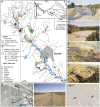
A hydromorphic reevaluation of the forgotten river civilizations of Central Asia
- PMID: 33318206
- PMCID: PMC7776828
- DOI: 10.1073/pnas.2009553117
A hydromorphic reevaluation of the forgotten river civilizations of Central Asia
Abstract
The Aral Sea basin in Central Asia and its major rivers, the Amu Darya and Syr Darya, were the center of advanced river civilizations, and a principal hub of the Silk Roads over a period of more than 2,000 y. The region's decline has been traditionally attributed to the devastating Mongol invasion of the early-13th century CE. However, the role of changing hydroclimatic conditions on the development of these culturally influential potamic societies has not been the subject of modern geoarchaeological investigations. In this paper we report the findings of an interdisciplinary investigation of archaeological sites and associated irrigation canals of the Otrār oasis, a United Nations Educational, Scientific and Cultural Organization (UNESCO) World Heritage site located at the confluence of the Syr Darya and Arys rivers in southern Kazakhstan. This includes radiometric dating of irrigation canal abandonment and an investigation of Arys river channel dynamics. Major phases of fluvial aggradation, between the seventh and early ninth century CE and between 1350 and 1550 CE coincide with economic flourishing of the oasis, facilitated by wet climatic conditions and higher river flows that favored floodwater farming. Periods of abandonment of the irrigation network and cultural decline primarily correlate with fluvial entrenchment during periods of drought, instead of being related to destructive invasions. Therefore, it seems the great rivers of Central Asia were not just static "stage sets" for some of the turning points of world history, but in many instances, inadvertently or directly shaped the final outcomes and legacies of imperial ambitions in the region.
Keywords: OSL dating; Otrar; Syr Darya; floodwater farming; fluvial geomorphology.
Conflict of interest statement
The authors declare no competing interest.
Figures


References
-
- Macklin M. G., Lewin J., The rivers of civilization. Quat. Sci. Rev. 114, 228–244 (2015).
-
- Gulyamov Y. G., The History of Irrigation of Khorezm from the Ancient to Present (in Russian) (Academy of Sciences of the Soviet Uzbek Republic, Taskhkent, 1957).
-
- Andrianov B. V., Drevnie Orositelnie Sistemi Priaralia (Izdatelstvo NAUKA Mosvka, 1969).
-
- Lewis R. A., Early irrigation in West Turkestan. Ann. Am. Assoc. Geogr. 56, 467–491 (1966).
-
- Andrianov B. V., Mantellini S., Ancient Irrigation Systems of the Aral Sea Area: The History and Development of Irrigated Agriculture (Oxbow Books, Oxford, 2016).
Publication types
LinkOut - more resources
Full Text Sources

