

Large-scale mapping of live corals to guide reef conservation
- PMID: 33318215
- PMCID: PMC7776917
- DOI: 10.1073/pnas.2017628117
Large-scale mapping of live corals to guide reef conservation
Abstract
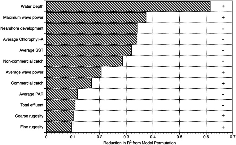
Coral is the life-form that underpins the habitat of most tropical reef ecosystems, thereby supporting biological diversity throughout the marine realm. Coral reefs are undergoing rapid change from ocean warming and nearshore human activities, compromising a myriad of services provided to societies including coastal protection, fishing, and cultural practices. In the face of these challenges, large-scale operational mapping of live coral cover within and across reef ecosystems could provide more opportunities to address reef protection, resilience, and restoration at broad management- and policy-relevant scales. We developed an airborne mapping approach combining laser-guided imaging spectroscopy and deep learning models to quantify, at a large archipelago scale, the geographic distribution of live corals to 16-m water depth throughout the main Hawaiian islands. Airborne estimates of live coral cover were highly correlated with field-based estimates of live coral cover (R2 = 0.94). Our maps were used to assess the relative condition of reefs based on live coral, and to identify potential coral refugia in the face of human-driven stressors, including marine heat waves. Geospatial modeling revealed that water depth, wave power, and nearshore development accounted for the majority (>60%) of live coral cover variation, but other human-driven factors were also important. Mapped interisland and intraisland variation in live coral location improves our understanding of reef geography and its human impacts, thereby guiding environmental management for reef resiliency.
Keywords: Hawaiian Islands; coral mapping; coral reef; coral refugia; reef restoration.
Conflict of interest statement
The authors declare no competing interest.
Figures


References
-
- Hughes T. P., et al. , Coral reefs in the Anthropocene. Nature 546, 82–90 (2017). - PubMed
-
- Hoegh-Guldberg O., et al. , Coral reefs under rapid climate change and ocean acidification. Science 318, 1737–1742 (2007). - PubMed
-
- Kutser T., Hedley J., Giardino C., Roelfsema C., Brando V. E., Remote sensing of shallow waters—a 50 year retrospective and future directions. Remote Sens. Environ. 240, 111619 (2020).
-
- Keppel G., Wardell‐Johnson G. W., Refugia: Keys to climate change management. Glob. Change Biol. 18, 2389–2391 (2012).
-
- Keppel G., et al. , The capacity of refugia for conservation planning under climate change. Front. Ecol. Environ. 13, 106–112 (2015).
Publication types
MeSH terms
LinkOut - more resources
Full Text Sources
