doi: 10.3201/eid2702.191701.
Combined Epidemiologic and Entomologic Survey to Detect Urban Malaria Transmission, Guinea, 2018
- PMID: 33496219
- PMCID: PMC7853535
- DOI: 10.3201/eid2702.191701
Item in Clipboard
Combined Epidemiologic and Entomologic Survey to Detect Urban Malaria Transmission, Guinea, 2018
Emerg Infect Dis.
2021 Feb.
Abstract
Malaria incidence is generally lower in cities than rural areas. However, reported urban malaria incidence may not accurately reflect the level of ongoing transmission, which has potentially large implications for prevention efforts. To guide mosquito net distribution, we assessed the extent of malaria transmission in Conakry, Guinea, in 2018. We found evidence of active malaria transmission.
Keywords: Anopheles gambiae; Conakry; Guinea; Plasmodium falciparum; entomology; epidemiology; malaria; mosquito; parasites; sub-Saharan Africa; transmission; urban; vector-borne infections.
Figures
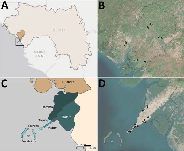
Administrative boundaries and location of communities visited as part of an epidemiologic–entomologic survey in Conakry and Dubréka, 2018. A) The positions of study sites are shown within the context of West Africa specifically Guinea. Turquoise area denotes Conakry and khaki Dubréka. Black square represents boundaries of the area depicted in panel B. B) Satellite imagery of Dubréka (outlined in black) and surrounding areas, with participating households shown as black points. C) Locations of 5 administrative communes within Conakry are shown in shades of turquoise; Dubréka is colored khaki. D) Satellite imagery of Conakry (outlined in black) and surrounding areas, with households participating in the survey shown as black points. Global positioning system coordinates of households were jittered for confidentiality before mapping in both (B) and (D).
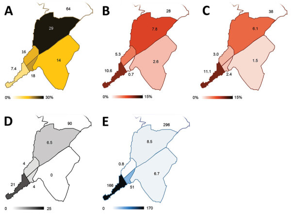
Spatial distribution of key malaria indices across Conakry, Guinea, as assessed during the rapid epidemiologic–entomologic investigation, November–December 2018. Indices are shown grouped by commune within Conakry. A) Proportion of the population reporting sleeping in a space with a mosquito net hanging. B) Malaria prevalence (%) in the sample population > 5 years of age, as determined by RDT during community survey. C) Malaria prevalence (%) in the sample population <5 years of age, as determined by RDT during community survey. D) Number of adult female Anopheles mosquitoes collected per night, averaged over 2 nights of collection. E) Annualized malaria incidence, reported as cases/1,000 population, diagnosed in local healthcare facilities. RDT, rapid diagnostic test.
References
-
- Camara A, Guilavogui T, Keita K, Dioubaté M, Barry Y, Camara D, et al. Rapid epidemiological and entomological survey for validation of reported indicators and characterization of local malaria transmission in Guinea, 2017. Am J Trop Med Hyg. 2018;99:1134–44. 10.4269/ajtmh.18-0479 - DOI - PMC - PubMed
Publication types
MeSH terms
LinkOut - more resources
Full Text Sources
Other Literature Sources
Medical