

Current advisory interventions for grazing ruminant farming cannot close exceedance of modern background sediment loss - Assessment using an instrumented farm platform and modelled scaling out
- PMID: 33613120
- PMCID: PMC7883306
- DOI: 10.1016/j.envsci.2020.11.004
Current advisory interventions for grazing ruminant farming cannot close exceedance of modern background sediment loss - Assessment using an instrumented farm platform and modelled scaling out
Abstract
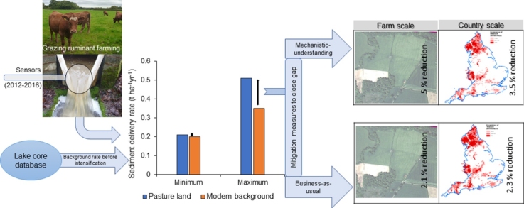
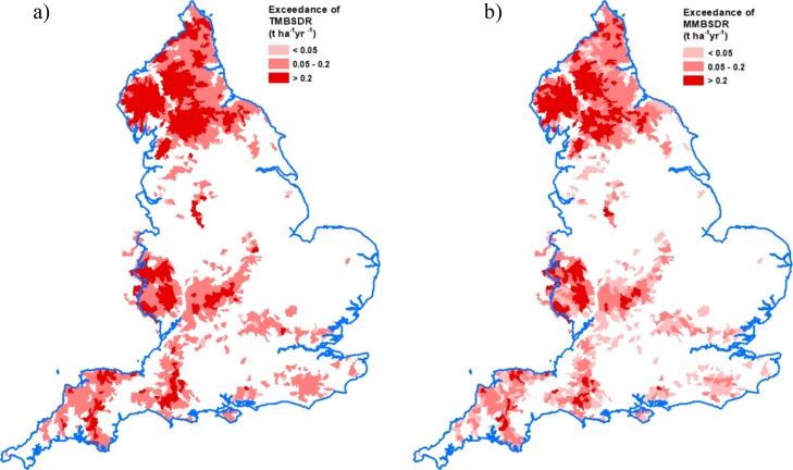
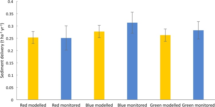
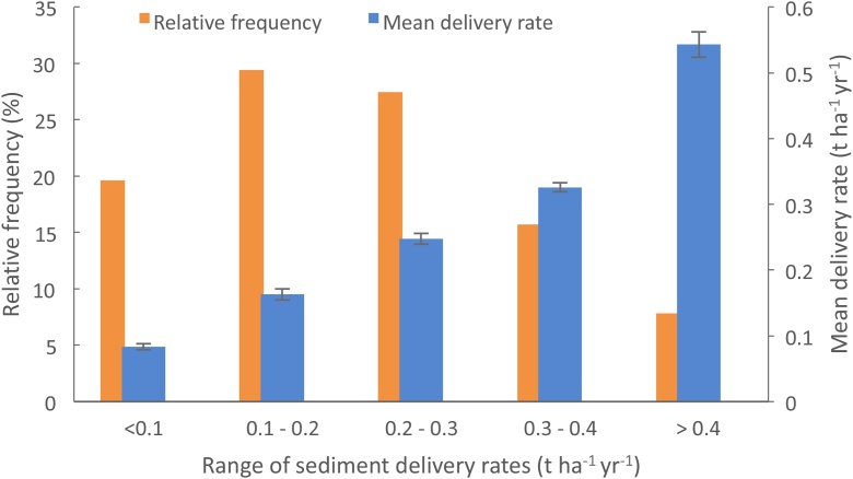
Water quality impairment by elevated sediment loss is a pervasive problem for global water resources. Sediment management targets identify exceedance or the sediment loss 'gap' requiring mitigation. In the UK, palaeo-limnological reconstruction of sediment loss during the 100-150 years pre-dating the post-World War II intensification of agriculture, has identified management targets (0.20-0.35 t ha-1 yr-1) representing 'modern background sediment delivery to rivers'. To assess exceedance on land for grazing ruminant farming, an integrated approach combined new mechanistic evidence from a heavily-instrumented experimental farm platform and a scaling out framework of modelled commercial grazing ruminant farms in similar environmental settings. Monitoring (2012-2016) on the instrumented farm platform returned sediment loss ranges of 0.11-0.14 t ha-1 yr-1 and 0.21-0.25 t ha-1 yr-1 on permanent pasture, compared with between 0.19-0.23 t ha-1 yr-1 and 0.43-0.50 t ha-1 yr-1and 0.10-0.13 t ha-1 yr-1and 0.25-0.30 t ha-1 yr-1 on pasture with scheduled plough and reseeds. Excess sediment loss existed on all three farm platform treatments but was more extensive on the two treatments with scheduled plough and reseeds. Excessive sediment loss from land used by grazing ruminant farming more strategically across England, was estimated to be up to >0.2 t ha-1 yr-1. Modelled scenarios of alternative farming futures, based on either increased uptake of interventions typically recommended by visual farm audits, or interventions selected using new mechanistic understanding for sediment loss from the instrumented farm platform, returned minimum sediment loss reductions. On the farm platform these were 2.1 % (up to 0.007 t ha-1 yr-1) and 5.1 % (up to 0.018 t ha-1 yr-1). More strategically, these were up to 2.8 % (0.014 t ha-1 yr-1) and 4.1 % (0.023 t ha-1 yr-1). Conventional on-farm measures will therefore not fully mitigate the sediment loss gap, meaning that more severe land cover change is required.
Keywords: Mitigation; Ruminant farming; Sediment; Soil erosion.
© 2020 The Author(s).
Conflict of interest statement
The authors declare that they have no known competing financial interests or personal relationships that could have appeared to influence the work reported in this paper.
Figures


Similar articles
-
Does cattle and sheep grazing under best management significantly elevate sediment losses? Evidence from the North Wyke Farm Platform, UK.J Soils Sediments. 2021;21(4):1875-1889. doi: 10.1007/s11368-021-02909-y. Epub 2021 Mar 13. J Soils Sediments. 2021. PMID: 34720744 Free PMC article.
-
Sediment loss in response to scheduled pasture ploughing and reseeding: The importance of soil moisture content in controlling risk.Soil Tillage Res. 2020 Oct;204:104746. doi: 10.1016/j.still.2020.104746. Soil Tillage Res. 2020. PMID: 33012929 Free PMC article.
-
Tackling unintended consequences of grazing livestock farming: Multi-scale assessment of co-benefits and trade-offs for water pollution mitigation scenarios.J Clean Prod. 2022 Feb 15;336:130449. doi: 10.1016/j.jclepro.2022.130449. J Clean Prod. 2022. PMID: 35177880 Free PMC article.
-
Soil erosion, sediment sources, connectivity and suspended sediment yields in UK temperate agricultural catchments: Discrepancies and reconciliation of field-based measurements.J Environ Manage. 2024 Feb;351:119810. doi: 10.1016/j.jenvman.2023.119810. Epub 2023 Dec 14. J Environ Manage. 2024. PMID: 38100866 Review.
-
Taking the steps toward sustainable livestock: our multidisciplinary global farm platform journey.Anim Front. 2021 Oct 20;11(5):52-58. doi: 10.1093/af/vfab048. eCollection 2021 Oct. Anim Front. 2021. PMID: 34676139 Free PMC article. Review. No abstract available.
Cited by
-
Soil N2O and CH4 emissions from fodder maize production with and without riparian buffer strips of differing vegetation.Plant Soil. 2022;477(1-2):297-318. doi: 10.1007/s11104-022-05426-0. Epub 2022 Apr 11. Plant Soil. 2022. PMID: 36120385 Free PMC article.
-
Exploring the effects of land management change on productivity, carbon and nutrient balance: Application of an Ensemble Modelling Approach to the upper River Taw observatory, UK.Sci Total Environ. 2022 Jun 10;824:153824. doi: 10.1016/j.scitotenv.2022.153824. Epub 2022 Feb 16. Sci Total Environ. 2022. PMID: 35182632 Free PMC article.
-
Does cattle and sheep grazing under best management significantly elevate sediment losses? Evidence from the North Wyke Farm Platform, UK.J Soils Sediments. 2021;21(4):1875-1889. doi: 10.1007/s11368-021-02909-y. Epub 2021 Mar 13. J Soils Sediments. 2021. PMID: 34720744 Free PMC article.
-
Diffuse water pollution during recent extreme wet-weather in the UK: Environmental damage costs and insight into the future?J Clean Prod. 2022 Mar 1;338:130633. doi: 10.1016/j.jclepro.2022.130633. J Clean Prod. 2022. PMID: 35241877 Free PMC article.
-
Feasibility of mitigation measures for agricultural greenhouse gas emissions in the UK. A systematic review.Agron Sustain Dev. 2024;44(1):2. doi: 10.1007/s13593-023-00938-0. Epub 2023 Dec 28. Agron Sustain Dev. 2024. PMID: 38161803 Free PMC article. Review.
References
-
- Avery B.W. Soil Survey of England and Wales; Harpenden: 1980. Soil Classification for England and Wales: Higher Categories. Technical Monograph No 14.
-
- Balmford A., Amano T., Bartlett H., Chadwick D., Collins A., Edwards D., Field R., Garnsworthy P., Green R., Smith P., Waters H., Whitmore A., Broom D.M., Chara J., Finch T., Garnett E., Gathorne-Hardy A., Hernandez-Medrano J., Herrero M., Hua F., Latawiec A., Misselbrook T., Phalan Simmons B.I., Takahashi T., Vause J., zu Ermgassen E., Eisner R. The environmental costs and benefits of high-yield farming. Nat. Sustain. 2018;1:477–485. - PMC - PubMed
-
- Barrow E., Hulme M., Jiang T. Climatic Research Unit; Norwich: 1993. A 1961-1990 Baseline Climatology and Future Climate Change Scenarios for Great Britain and Europe. Part I: 1961-1990 Great Britain Baseline Climatology. 43pp.
-
- Bibby J.S., Douglas H.A., Thomasson A.J., Robertson J.S. Macaulay Land Use Research Institute; Aberdeen, Scotland: 1982. Land Capability Classification for Agriculture.
-
- Biddulph M., Collins A.L., Foster I.D.L., Holmes N. The scale problem in tackling diffuse water pollution from agriculture: insights from the Avon Demonstration Test Catchment programme in England. River Res. Appl. 2017;33:1527–1538.
Grants and funding
LinkOut - more resources
Full Text Sources
Other Literature Sources
Research Materials
Miscellaneous