

Identification of superspreading environment under COVID-19 through human mobility data
- PMID: 33633273
- PMCID: PMC7907097
- DOI: 10.1038/s41598-021-84089-w
Identification of superspreading environment under COVID-19 through human mobility data
Abstract
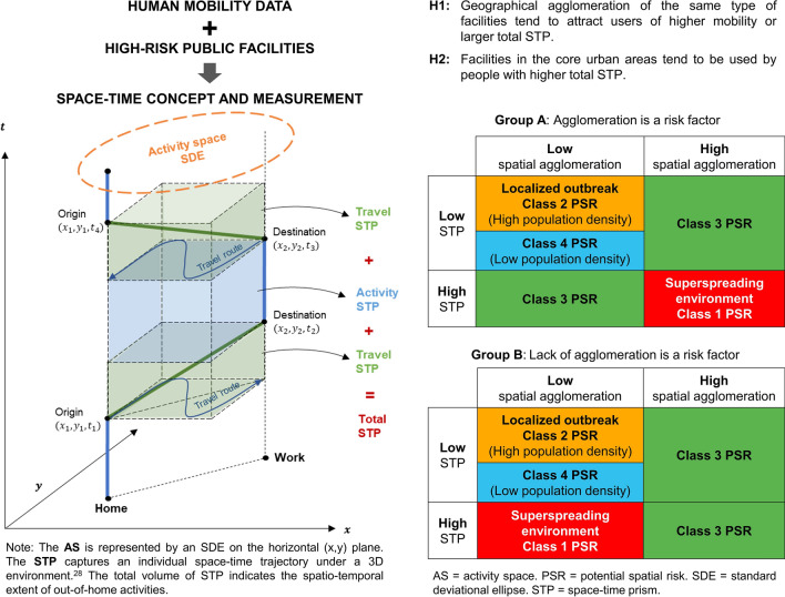
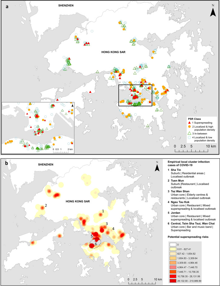
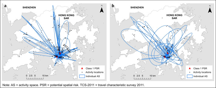
COVID-19 reaffirms the vital role of superspreaders in a pandemic. We propose to broaden the research on superspreaders through integrating human mobility data and geographical factors to identify superspreading environment. Six types of popular public facilities were selected: bars, shopping centres, karaoke/cinemas, mega shopping malls, public libraries, and sports centres. A historical dataset on mobility was used to calculate the generalized activity space and space-time prism of individuals during a pre-pandemic period. Analysis of geographic interconnections of public facilities yielded locations by different classes of potential spatial risk. These risk surfaces were weighed and integrated into a "risk map of superspreading environment" (SE-risk map) at the city level. Overall, the proposed method can estimate empirical hot spots of superspreading environment with statistical accuracy. The SE-risk map of Hong Kong can pre-identify areas that overlap with the actual disease clusters of bar-related transmission. Our study presents first-of-its-kind research that combines data on facility location and human mobility to identify superspreading environment. The resultant SE-risk map steers the investigation away from pure human focus to include geographic environment, thereby enabling more differentiated non-pharmaceutical interventions and exit strategies to target some places more than others when complete city lockdown is not practicable.
Conflict of interest statement
The authors declare no competing interests.
Figures
Similar articles
-
Spatial risk for a superspreading environment: Insights from six urban facilities in six global cities across four continents.Front Public Health. 2023 Apr 5;11:1128889. doi: 10.3389/fpubh.2023.1128889. eCollection 2023. Front Public Health. 2023. PMID: 37089495 Free PMC article.
-
Association between meteorological variations and the superspreading potential of SARS-CoV-2 infections.Environ Int. 2024 Jun;188:108762. doi: 10.1016/j.envint.2024.108762. Epub 2024 May 19. Environ Int. 2024. PMID: 38776652
-
The superspreading places of COVID-19 and the associated built-environment and socio-demographic features: A study using a spatial network framework and individual-level activity data.Health Place. 2021 Nov;72:102694. doi: 10.1016/j.healthplace.2021.102694. Epub 2021 Oct 9. Health Place. 2021. PMID: 34649210 Free PMC article.
-
Superspreading, overdispersion and their implications in the SARS-CoV-2 (COVID-19) pandemic: a systematic review and meta-analysis of the literature.BMC Public Health. 2023 May 30;23(1):1003. doi: 10.1186/s12889-023-15915-1. BMC Public Health. 2023. PMID: 37254143 Free PMC article.
-
Impact of diabetes on COVID-19 and other infection: Report from the 22nd Hong Kong Diabetes and Cardiovascular Risk Factors-East Meets West Symposium.Diabet Med. 2021 May;38(5):e14547. doi: 10.1111/dme.14547. Epub 2021 Mar 2. Diabet Med. 2021. PMID: 33615546 Free PMC article. Review.
Cited by
-
Spatio-temporal variations of traffic congestion under work from home (WFH) arrangements: Lessons learned from COVID-19.Cities. 2022 May;124:103610. doi: 10.1016/j.cities.2022.103610. Epub 2022 Jan 24. Cities. 2022. PMID: 35095163 Free PMC article.
-
Responsiveness of open innovation to COVID-19 pandemic: The case of data for good.PLoS One. 2022 Apr 26;17(4):e0267100. doi: 10.1371/journal.pone.0267100. eCollection 2022. PLoS One. 2022. PMID: 35472151 Free PMC article.
-
Spatial risk for a superspreading environment: Insights from six urban facilities in six global cities across four continents.Front Public Health. 2023 Apr 5;11:1128889. doi: 10.3389/fpubh.2023.1128889. eCollection 2023. Front Public Health. 2023. PMID: 37089495 Free PMC article.
-
Optimized workplace risk mitigation measures for SARS-CoV-2 in 2022.Sci Rep. 2023 Feb 16;13(1):2779. doi: 10.1038/s41598-023-29087-w. Sci Rep. 2023. PMID: 36797293 Free PMC article.
-
Spatiotemporal hierarchical Bayesian analysis to identify factors associated with COVID-19 in suburban areas in Colombia.Heliyon. 2024 Apr 24;10(9):e30182. doi: 10.1016/j.heliyon.2024.e30182. eCollection 2024 May 15. Heliyon. 2024. PMID: 38707376 Free PMC article.
References
-
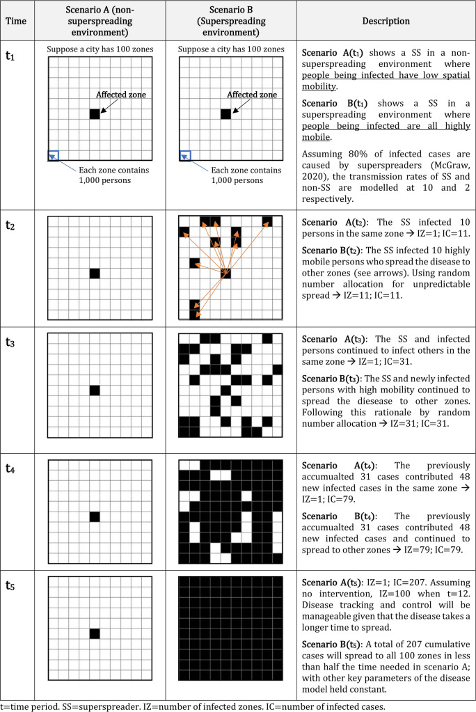
- McGraw, E. What is a Super Spreader? An Infectious Disease Expert Explains. https://theconversation.com/what-is-a-super-spreader-an-infectious-disea... (2020).
MeSH terms
LinkOut - more resources
Full Text Sources
Other Literature Sources
Medical
