

Mapping suitability for Buruli ulcer at fine spatial scales across Africa: A modelling study
- PMID: 33657104
- PMCID: PMC7959670
- DOI: 10.1371/journal.pntd.0009157
Mapping suitability for Buruli ulcer at fine spatial scales across Africa: A modelling study
Abstract
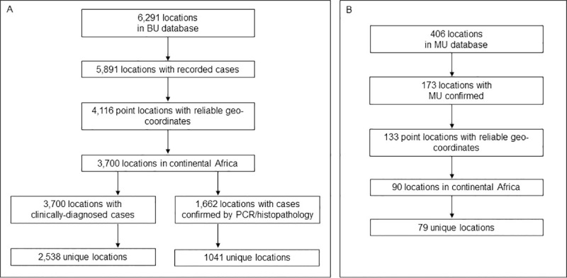
Buruli ulcer (BU) is a disabling and stigmatising neglected tropical disease (NTD). Its distribution and burden are unknown because of underdiagnosis and underreporting. It is caused by Mycobacterium ulcerans, an environmental pathogen whose environmental niche and transmission routes are not fully understood. The main control strategy is active surveillance to promote early treatment and thus limit morbidity, but these activities are mostly restricted to well-known endemic areas. A better understanding of environmental suitability for the bacterium and disease could inform targeted surveillance, and advance understanding of the ecology and burden of BU. We used previously compiled point-level datasets of BU and M. ulcerans occurrence, evidence for BU occurrence within national and sub-national areas, and a suite of relevant environmental covariates in a distribution modelling framework. We fitted relationships between BU and M. ulcerans occurrence and environmental predictors by applying regression and machine learning based algorithms, combined in an ensemble model to characterise the optimal ecological niche for the disease and bacterium across Africa at a resolution of 5km x 5km. Proximity to waterbodies was the strongest predictor of suitability for BU, followed potential evapotranspiration. The strongest predictors of suitability for M. ulcerans were deforestation and potential evapotranspiration. We identified patchy foci of suitability throughout West and Central Africa, including areas with no previous evidence of the disease. Predicted suitability for M. ulcerans was wider but overlapping with that of BU. The estimated population living in areas predicted suitable for the bacterium and disease was 46.1 million. These maps could be used to inform burden estimations and case searches which would generate a more complete understanding of the spatial distribution of BU in Africa, and may guide control programmes to identify cases beyond the well-known endemic areas.
Conflict of interest statement
The authors have declared that no competing interests exist.
Figures


References
-
- Roltgen K, Pluschke G. Epidemiology and disease burden of Buruli ulcer: a review. Res Rep Trop Med. 2015;6:59–73. 10.2147/rrtm.s62026 WOS:000219035500008. - DOI
Publication types
MeSH terms
Grants and funding
LinkOut - more resources
Full Text Sources
Other Literature Sources
