

Benthic and coral reef community field data for Heron Reef, Southern Great Barrier Reef, Australia, 2002-2018
- PMID: 33727570
- PMCID: PMC7966393
- DOI: 10.1038/s41597-021-00871-5
Benthic and coral reef community field data for Heron Reef, Southern Great Barrier Reef, Australia, 2002-2018
Abstract
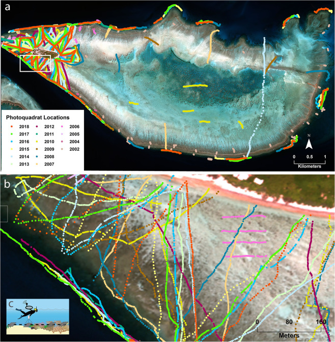
This paper describes benthic coral reef community composition point-based field data sets derived from georeferenced photoquadrats using machine learning. Annually over a 17 year period (2002-2018), data were collected using downward-looking photoquadrats that capture an approximately 1 m2 footprint along 100 m-1500 m transect surveys distributed along the reef slope and across the reef flat of Heron Reef (28 km2), Southern Great Barrier Reef, Australia. Benthic community composition for the photoquadrats was automatically interpreted through deep learning, following initial manual calibration of the algorithm. The resulting data sets support understanding of coral reef biology, ecology, mapping and dynamics. Similar methods to derive the benthic data have been published for seagrass habitats, however here we have adapted the methods for application to coral reef habitats, with the integration of automatic photoquadrat analysis. The approach presented is globally applicable for various submerged and benthic community ecological applications, and provides the basis for further studies at this site, regional to global comparative studies, and for the design of similar monitoring programs elsewhere.
Conflict of interest statement
The authors declare no competing interests.
Figures
Similar articles
-
Coral community data Heron Island Great Barrier Reef 1962-2016.Sci Data. 2022 Oct 12;9(1):617. doi: 10.1038/s41597-022-01747-y. Sci Data. 2022. PMID: 36224212 Free PMC article.
-
Field data sets for seagrass biophysical properties for the Eastern Banks, Moreton Bay, Australia, 2004-2014.Sci Data. 2015 Aug 4;2:150040. doi: 10.1038/sdata.2015.40. eCollection 2015. Sci Data. 2015. PMID: 26396742 Free PMC article.
-
Predicting the location and spatial extent of submerged coral reef habitat in the Great Barrier Reef world heritage area, Australia.PLoS One. 2012;7(10):e48203. doi: 10.1371/journal.pone.0048203. Epub 2012 Oct 30. PLoS One. 2012. PMID: 23118952 Free PMC article.
-
Representation and complementarity of the long-term coral monitoring on the Great Barrier Reef.Ecol Appl. 2020 Sep;30(6):e02122. doi: 10.1002/eap.2122. Epub 2020 Apr 15. Ecol Appl. 2020. PMID: 32159898 Review.
-
Biological and remote sensing perspectives of pigmentation in coral reef organisms.Adv Mar Biol. 2002;43:277-317. doi: 10.1016/s0065-2881(02)43006-4. Adv Mar Biol. 2002. PMID: 12154614 Review.
Cited by
-
A doubling of stony coral cover on shallow forereefs at Carrie Bow Cay, Belize from 2014 to 2019.Sci Rep. 2021 Sep 28;11(1):19185. doi: 10.1038/s41598-021-96799-2. Sci Rep. 2021. PMID: 34584122 Free PMC article.
References
-
- Lyons, M. et al. Mapping the world’s coral reefs using a global multiscale earth observation framework. Remote Sensing in Ecology and Conservation6, 10.1002/rse2.157 (2020).
-
- Congalton, R. G. & Green, K. Assessing the accuracy of remotely sensed data: Principles and practices. Mapping Science. 2 edn, 200 (CRC Press, 2008).
-
- Andréfouët S, et al. Multi-site evaluation of IKONOS data for classification of tropical coral reef environments. Remote Sensing of Environment. 2003;88:128–143. doi: 10.1016/j.rse.2003.04.005. - DOI
-
- González-Rivero M, et al. Scaling up Ecological Measurements of Coral Reefs Using Semi-Automated Field Image Collection and Analysis. Remote Sensing. 2016;8:30. doi: 10.3390/rs8010030. - DOI
Publication types
MeSH terms
LinkOut - more resources
Full Text Sources
Other Literature Sources
