

Excess mortality during the COVID-19 pandemic: a geospatial and statistical analysis in Aden governorate, Yemen
- PMID: 33758012
- PMCID: PMC7992372
- DOI: 10.1136/bmjgh-2020-004564
Excess mortality during the COVID-19 pandemic: a geospatial and statistical analysis in Aden governorate, Yemen
Abstract
Background: The burden of COVID-19 in low-income and conflict-affected countries remains unclear, largely reflecting low testing rates. In parts of Yemen, reports indicated a peak in hospital admissions and burials during May-June 2020. To estimate excess mortality during the epidemic period, we quantified activity across all identifiable cemeteries within Aden governorate (population approximately 1 million) by analysing very high-resolution satellite imagery and compared estimates to Civil Registry office records.
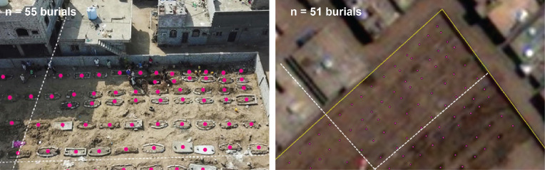
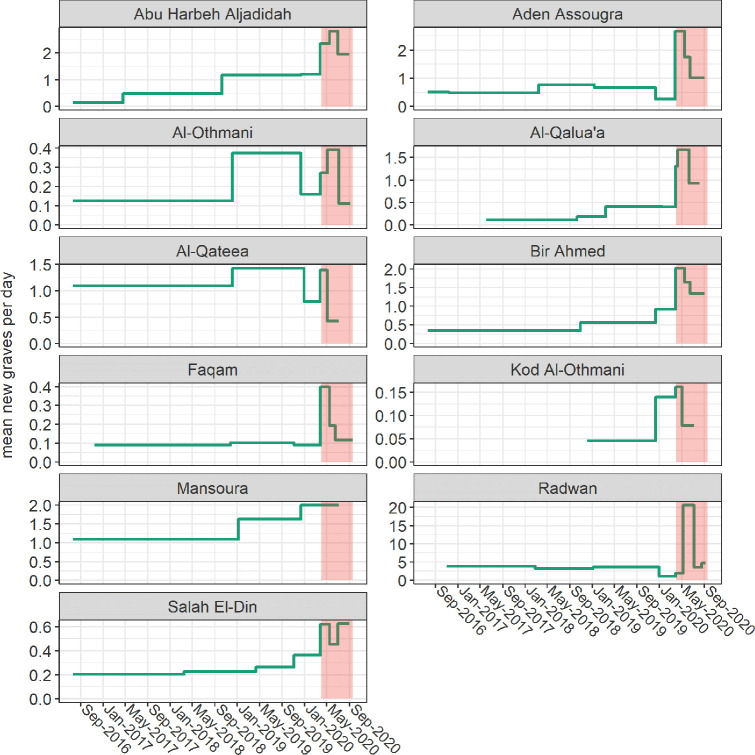
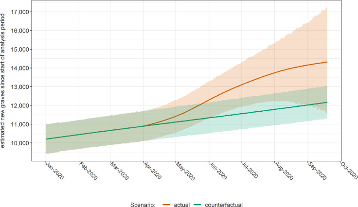
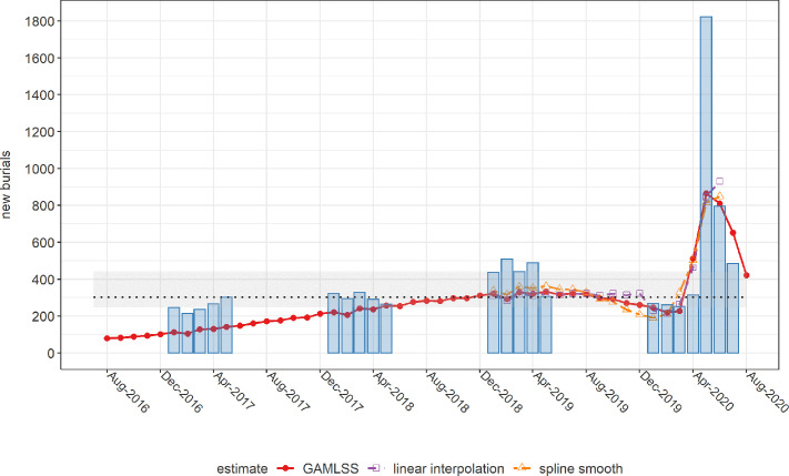
Methods: After identifying active cemeteries through remote and ground information, we applied geospatial analysis techniques to manually identify new grave plots and measure changes in burial surface area over a period from July 2016 to September 2020. After imputing missing grave counts using surface area data, we used alternative approaches, including simple interpolation and a generalised additive mixed growth model, to predict both actual and counterfactual (no epidemic) burial rates by cemetery and across the governorate during the most likely period of COVID-19 excess mortality (from 1 April 2020) and thereby compute excess burials. We also analysed death notifications to the Civil Registry office over the same period.
Results: We collected 78 observations from 11 cemeteries. In all but one, a peak in daily burial rates was evident from April to July 2020. Interpolation and mixed model methods estimated ≈1500 excess burials up to 6 July, and 2120 up to 19 September, corresponding to a peak weekly increase of 230% from the counterfactual. Satellite imagery estimates were generally lower than Civil Registry data, which indicated a peak 1823 deaths in May alone. However, both sources suggested the epidemic had waned by September 2020.
Discussion: To our knowledge, this is the first instance of satellite imagery being used for population mortality estimation. Findings suggest a substantial, under-ascertained impact of COVID-19 in this urban Yemeni governorate and are broadly in line with previous mathematical modelling predictions, though our method cannot distinguish direct from indirect virus deaths. Satellite imagery burial analysis appears a promising novel approach for monitoring epidemics and other crisis impacts, particularly where ground data are difficult to collect.
Keywords: COVID-19; epidemiology; geographic information systems; public Health.
© Author(s) (or their employer(s)) 2021. Re-use permitted under CC BY-NC. No commercial re-use. See rights and permissions. Published by BMJ.
Conflict of interest statement
Competing interests: None declared.
Figures

Comment in
-
A strategy for SARS-CoV-2 vaccination in Yemen.Lancet. 2021 Jun 12;397(10291):2247. doi: 10.1016/S0140-6736(21)01016-3. Lancet. 2021. PMID: 34119057 Free PMC article. No abstract available.
References
-
- Humanitarian Country Team . Yemen prepardness and response snapchot COVID-19. Reliefweb, 2020. Available: https://reliefweb.int/report/yemen/yemen-covid-19-preparedness-and-respo...
-
- Stone M. Coronavirus will ‘delete Yemen from maps all over the world’ | World News | Sky News. Sky News, 2020. Available: https://news.sky.com/story/coronavirus-will-delete-yemen-from-maps-all-o...
-
- Pearson CAB, et al. Modelling projections for COVID19 epidemic in Yemen 2020.
-
- ACAPS . COVID-19 - Impact on Yemen, 2020. Available: https://www.acaps.org/special-report/covid-19-impact-yemen#:~:text=The%2...
Publication types
MeSH terms
LinkOut - more resources
Full Text Sources
Other Literature Sources
Medical
Miscellaneous