

Temporal and spatial lags between wind, coastal upwelling, and blue whale occurrence
- PMID: 33767285
- PMCID: PMC7994810
- DOI: 10.1038/s41598-021-86403-y
Temporal and spatial lags between wind, coastal upwelling, and blue whale occurrence
Abstract
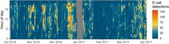
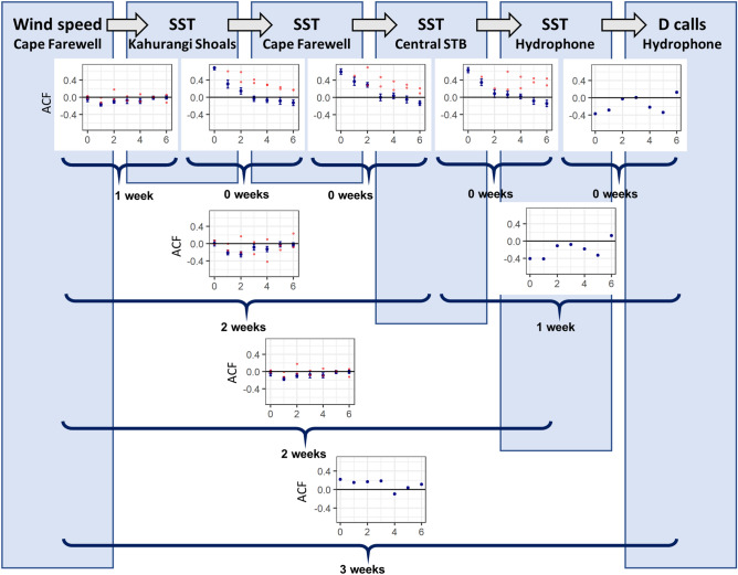
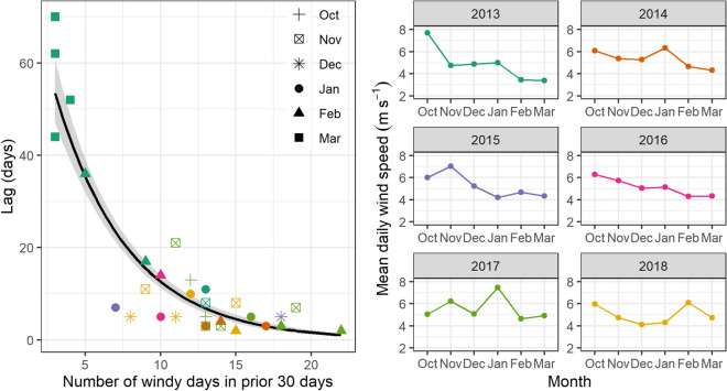
Understanding relationships between physical drivers and biological response is central to advancing ecological knowledge. Wind is the physical forcing mechanism in coastal upwelling systems, however lags between wind input and biological responses are seldom quantified for marine predators. Lags were examined between wind at an upwelling source, decreased temperatures along the upwelling plume's trajectory, and blue whale occurrence in New Zealand's South Taranaki Bight region (STB). Wind speed and sea surface temperature (SST) were extracted for austral spring-summer months between 2009 and 2019. A hydrophone recorded blue whale vocalizations October 2016-March 2017. Timeseries cross-correlation analyses were conducted between wind speed, SST at different locations along the upwelling plume, and blue whale downswept vocalizations (D calls). Results document increasing lag times (0-2 weeks) between wind speed and SST consistent with the spatial progression of upwelling, culminating with increased D call density at the distal end of the plume three weeks after increased wind speeds at the upwelling source. Lag between wind events and blue whale aggregations (n = 34 aggregations 2013-2019) was 2.09 ± 0.43 weeks. Variation in lag was significantly related to the amount of wind over the preceding 30 days, which likely influences stratification. This study enhances knowledge of physical-biological coupling in upwelling ecosystems and enables improved forecasting of species distribution patterns for dynamic management.
Conflict of interest statement
The authors declare no competing interests.
Figures

References
-
- Mann KH, Lazier JRN. Dynamics of marine ecosystems: Biological-physical interactions in the oceans. Blackwell Sci. Publ. 1996 doi: 10.2307/2960585. - DOI
-
- Cushing DH. Plankton production and year-class strength in fish populations: An update of the match/mismatch hypothesis. Adv. Mar. Biol. 1990;9:255–334. doi: 10.1016/S0065-2881(08)60344-2. - DOI
-
- Ekman, V. W. On the influence of the earth’s rotation on ocean-currents. (1905).
-
- Grémillet D, et al. Spatial match-mismatch in the Benguela upwelling zone: Should we expect chlorophyll and sea-surface temperature to predict marine predator distributions? J. Appl. Ecol. 2008;45:610–621. doi: 10.1111/j.1365-2664.2007.01447.x. - DOI
Publication types
LinkOut - more resources
Full Text Sources
Other Literature Sources
Miscellaneous
