Review
. 2021 Aug 1:780:146494.
doi: 10.1016/j.scitotenv.2021.146494. Epub 2021 Mar 17.

Soil erosion modelling: A global review and statistical analysis

Pasquale Borrelli  1 Christine Alewell  2 Pablo Alvarez  3 Jamil Alexandre Ayach Anache  4 Jantiene Baartman  5 Cristiano Ballabio  6 Nejc Bezak  7 Marcella Biddoccu  8 Artemi Cerdà  9 Devraj Chalise  10 Songchao Chen  11 Walter Chen  12 Anna Maria De Girolamo  13 Gizaw Desta Gessesse  14 Detlef Deumlich  15 Nazzareno Diodato  16 Nikolaos Efthimiou  17 Gunay Erpul  18 Peter Fiener  19 Michele Freppaz  20 Francesco Gentile  21 Andreas Gericke  22 Nigussie Haregeweyn  23 Bifeng Hu  24 Amelie Jeanneau  25 Konstantinos Kaffas  26 Mahboobeh Kiani-Harchegani  27 Ivan Lizaga Villuendas  28 Changjia Li  29 Luigi Lombardo  30 Manuel López-Vicente  31 Manuel Esteban Lucas-Borja  32 Michael Märker  33 Francis Matthews  6 Chiyuan Miao  34 Matjaž Mikoš  7 Sirio Modugno  35 Markus Möller  36 Victoria Naipal  37 Mark Nearing  38 Stephen Owusu  39 Dinesh Panday  40 Edouard Patault  41 Cristian Valeriu Patriche  42 Laura Poggio  43 Raquel Portes  44 Laura Quijano  45 Mohammad Reza Rahdari  46 Mohammed Renima  47 Giovanni Francesco Ricci  21 Jesús Rodrigo-Comino  48 Sergio Saia  49 Aliakbar Nazari Samani  50 Calogero Schillaci  51 Vasileios Syrris  6 Hyuck Soo Kim  52 Diogo Noses Spinola  53 Paulo Tarso Oliveira  54 Hongfen Teng  55 Resham Thapa  56 Konstantinos Vantas  57 Diana Vieira  58 Jae E Yang  52 Shuiqing Yin  34 Demetrio Antonio Zema  59 Guangju Zhao  60 Panos Panagos  61
Affiliations
Review

Soil erosion modelling: A global review and statistical analysis

Pasquale Borrelli et al. Sci Total Environ. .

Abstract

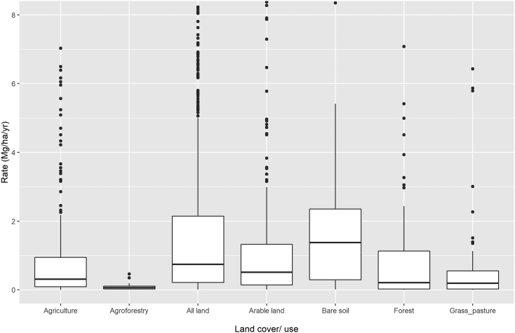
To gain a better understanding of the global application of soil erosion prediction models, we comprehensively reviewed relevant peer-reviewed research literature on soil-erosion modelling published between 1994 and 2017. We aimed to identify (i) the processes and models most frequently addressed in the literature, (ii) the regions within which models are primarily applied, (iii) the regions which remain unaddressed and why, and (iv) how frequently studies are conducted to validate/evaluate model outcomes relative to measured data. To perform this task, we combined the collective knowledge of 67 soil-erosion scientists from 25 countries. The resulting database, named 'Global Applications of Soil Erosion Modelling Tracker (GASEMT)', includes 3030 individual modelling records from 126 countries, encompassing all continents (except Antarctica). Out of the 8471 articles identified as potentially relevant, we reviewed 1697 appropriate articles and systematically evaluated and transferred 42 relevant attributes into the database. This GASEMT database provides comprehensive insights into the state-of-the-art of soil- erosion models and model applications worldwide. This database intends to support the upcoming country-based United Nations global soil-erosion assessment in addition to helping to inform soil erosion research priorities by building a foundation for future targeted, in-depth analyses. GASEMT is an open-source database available to the entire user-community to develop research, rectify errors, and make future expansions.

Keywords: Erosion rates; GIS; Land degradation; Land sustainability; Modelling; Policy support.


Conflict of interest statement

Declaration of competing interest The authors declare that they have no known competing financial interests or personal relationships that could have appeared to influence the work reported in this paper.

Figures

Unlabelled Image
Graphical abstract
Fig. 1
Fig. 1
Geographical distribution of 1833 of the 3030 GASEMT database records for which the study areas' geographical coordinates could be obtained. The modelling applications are grouped using a hexagonal grid with a Robinson projection to represent the density of observations optimally.
Fig. 2
Fig. 2
Number of publications catagorised by the simulated erosive agent in the GASEMT database through time (left panel, 4-year time windows) and overall 1994–2017 (right panel). Both panels share the same legend.
Fig. 3
Fig. 3
Distribution of the GASEMT database modelling applications according to spatial scale (other includes continental, farm, and global scale).
Fig. 4
Fig. 4
Number of publications according to models in the GASEMT database through time (left) (4-year time windows) and overall distribution (right).
Fig. 5
Fig. 5
Distribution of the estimated soil-erosion rates (gross and net) categorized by erosion agent (panel a), continent (panel b), and spatial scale (panel c). Values in the cells and colour legend represent the numbers of occurrences in the database.
Fig. 6
Fig. 6
Comparison of modelled erosion rates under different land covers. Note that the outliers >8 mm yr−1 are excluded in the graphic. The boxplots display the interquartile range (grey boxes), the median (horizontal bold black lines), the 10th and 90th percentile (horizontal black lines) and outliers (dots).
Fig. 7
Fig. 7
Comparison of the predicted soil erosion rates of the nine models most commonly occurring in the GASEMT database. Note that the outliers >100 Mg ha−1 yr−1 are excluded in the graphic. The boxplots display the interquartile range (grey boxes), the median (horizontal bold black lines), the 10th and 90th percentile (horizontal black bars), and outliers (dots).
Fig. 8
Fig. 8
Geographical distribution of the 1586 quantitative modelling estimates, including the study area's size (proportional to the size of circles) and predicted soil erosion rates (chromatic scale). Robinson projection.
Fig. 9
Fig. 9
Spatial distribution (Robinson projection) of the sites reported in García-Ruiz et al. (2015) database on soil erosion field measurements.
Fig. 10
Fig. 10
Geographical distribution (Robinson projection) of 1833 Global Applications of Soil Erosion Modelling Tracker (GASEMT), grouped using a hexagonal grid, superimposed on (panel a) the global cropland according to the IMAGE model year 2015 (Hurtt et al., 2020; Stehfest et al., 2014), (panel b) global annual rainfall (Hijmans et al., 2005), (panel c) global yearly changes in the agricultural area between the reference period 2015 and 2070 projections (Global Change Assessment Model (GCAM) RCP 6.0, Hurtt et al., 2020), and the water and wind erosion severity according to the Global Assessment of Soil Degradation (GLASOD) (panel d). The degree of damage is indicated from low (1) to severe (4). This figure is available at high-resolution in the Supplementary Information (Fig. S3).

References

    1. Alewell C., Borrelli P., Meusburger K., Panagos P. Using the USLE: chances, challenges and limitations of soil erosion modelling. Int. Soil Water Conserv. Res. 2019;7:203–225. doi: 10.1016/j.iswcr.2019.05.004. - DOI
    1. Arnold J.G., Srinivasan R., Muttiah R.S., Williams J.R. Large area hydrologic modeling and assesment part I: model development. JAWRA J. Am. Water Resour. Assoc. 1998;34:73–89. doi: 10.1111/j.1752-1688.1998.tb05961.x. - DOI
    1. Arnold, J.G., Moriasi, D.N., Gassman, P.W., Abbaspour, K.C., White, M.J., Srinivasan, R., Santhi, C., Harmel, R.D., Van Griensven, A., Van Liew, M.W., Kannan, N., Jha, M.K., 2012. SWAT: Model use, calibration, and validation. Trans. ASABE 55, 1491–1508. doi:10.13031/2013.42259. - DOI
    1. Auerswald K., Kainz M., Fiener P. Soil erosion potential of organic versus conventional farming evaluated by USLE modelling of cropping statistics for agricultural districts in Bavaria. Soil Use Manag. 2003;19:305–311. doi: 10.1079/SUM2003212. - DOI
    1. Auerswald K., Fiener P., Martin W., Elhaus D. Use and misuse of the K factor equation in soil erosion modeling: an alternative equation for determining USLE nomograph soil erodibility values. Catena. 2014;118:220–225. doi: 10.1016/j.catena.2014.01.008. - DOI