. 2021 Mar 24:12:649660.
doi: 10.3389/fpls.2021.649660. eCollection 2021.

Simulation of Wheat Productivity Using a Model Integrated With Proximal and Remotely Controlled Aerial Sensing Information

Affiliations

Simulation of Wheat Productivity Using a Model Integrated With Proximal and Remotely Controlled Aerial Sensing Information

Taehwan Shin et al. Front Plant Sci. .

Abstract

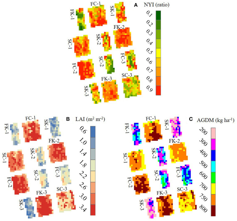
A crop model incorporating proximal sensing images from a remote-controlled aerial system (RAS) can serve as an enhanced alternative for monitoring field-based geospatial crop productivity. This study aimed to investigate wheat productivity for different cultivars and various nitrogen application regimes and determine the best management practice scenario. We simulated spatiotemporal wheat growth and yield by integrating RAS-based sensing images with a crop-modeling system to achieve the study objective. We conducted field experiments and proximal sensing campaigns to acquire the ground truth data and RAS images of wheat growth conditions and yields. These experiments were performed at Gyeongsang National University (GNU), Jinju, South Gyeongsang province, Republic of Korea (ROK), in 2018 and 2019 and at Chonnam National University (CNU), Gwangju, ROK, in 2018. During the calibration at GNU in 2018, the wheat yields simulated by the modeling system were in agreement with the corresponding measured yields without significant differences (p = 0.27-0.91), according to two-sample t-tests. Furthermore, the yields simulated via this approach were in agreement with the measured yields at CNU in 2018 and at GNU in 2019 without significant differences (p = 0.28-0.86), as evidenced by two-sample t-tests; this proved the validity of the proposed modeling system. This system, when integrated with remotely sensed images, could also accurately reproduce the geospatial variations in wheat yield and growth variables. Given the results of this study, we believe that the proposed crop-modeling approach is applicable for the practical monitoring of wheat growth and productivity at the field level.

Keywords: aerial images; crop model; proximal sensing; remotely controlled aerial system; simulation; wheat.


Conflict of interest statement

The authors declare that the research was conducted in the absence of any commercial or financial relationships that could be construed as a potential conflict of interest.

Figures

Figure 1
Figure 1
Schematic diagram of the remote sensing-integrated wheat model: (A) crop simulation procedure, (B) model parameterization based on remote sensing (RS) information, and (C) simulated and observed leaf area index (LAI) using the optimization process. AGDM and PAR represent above-ground dry mass and photosynthetically active radiation, respectively.
Figure 2
Figure 2
Simulated and measured leaf area index (LAI) and above-ground dry mass (AGDM) of Chokyung (A,C) and Keumkang (B,D) wheat seeded in spring (A,B) and fall (C,D) at Gyeongsang National University, Jinju, South Korea in 2018. Vertical bars represent the standard deviations of the mean values at 95% confidence intervals (n = 9).
Figure 3
Figure 3
Comparison between simulated and measured grain yields of Chokyung and Keumkang wheat seeded in spring (A,B) and fall (C,D) at Gyeongsang National University, Jinju, South Korea in 2018. Vertical bars represent the standard errors of the mean yields at 95% confidence intervals (n = 9).
Figure 4
Figure 4
Simulated and measured leaf area index (LAI) and above-ground dry mass (AGDM) vs. measured LAI and AGDM of Chokyung wheat at Chonnam National University, Gwangju, South Korea, in 2018. Vertical bars represent the standard deviations (A) and standard errors (B) of the mean values at 95% confidence intervals (n = 9).
Figure 5
Figure 5
Simulated and measured leaf area index (LAI) and above-ground dry mass (AGDM) of Chokyung wheat seeded in spring (A) and fall with different nitrogen applications of 40 kg ha−1 at planting, 30 kg ha−1 at rejuvenation, and 0 kg ha−1 at initial reproduction (N40-30-0) (B), N40-30-30 (C), and N40-30-60 (D) at Gyeongsang National University, Jinju, South Korea, in 2019. Vertical bars represent the standard deviations of the mean values at 95% confidence intervals (n = 9).
Figure 6
Figure 6
Comparison between simulated and measured grain yields of Chokyung wheat seeded in spring (A) and fall with different nitrogen applications of 40 kg ha−1 at planting, 30 kg ha−1 at rejuvenation, and 0 kg ha−1 at initial reproduction (N40-30-0) (B), N40-30-30 (C), and N40-30-60 (D) at Gyeongsang National University, Jinju, South Korea, in 2019. Vertical bars represent the standard errors of the mean values at 95% confidence intervals (n = 9).
Figure 7
Figure 7
Two-dimensional simulated projections of normalized yield index, NYI (A), leaf area index, LAI (B), and above-ground dry mass, AGDM (C) of two wheat cultivars seeded in fall and spring 2018 at Gyeongsang National University, Jinju, South Korea. The remote-controlled aerial image data for (B,C) were obtained 60 days after rejuvenation. FC, fall-seeded Chokyeong; FK, fall-seeded Keumkang; SC, spring-seeded Chokyeong; SK, spring-seeded Keumkang; the numbers after each upper character and dash symbol represent experimental blocks.
Figure 8
Figure 8
Two-dimensional simulated projections of normalized yield index, NYI (A), leaf area index, LAI (B), and above-ground dry mass, AGDM (C) of Chokyeong wheat treated with different nitrogen (N) levels at the tillering and heading stages at Gyeongsang National University, Jinju, South Korea, in 2019. The remote-controlled aerial image data for (B,C) were obtained 60 days after rejuvenation. FN1, fall-seeded with different nitrogen applications of 40 kg ha−1 at planting, 30 kg ha−1 at rejuvenation, and 0 kg ha−1 at initial reproduction (N40-30-0); FN2, fall-seeded N40-30-30; FN3, fall-seeded N40-30-60; SN, spring-seeded N40-30-30; the numbers after each dash symbol represent experimental blocks.
Figure 9
Figure 9
Two-dimensional simulated projections of normalized yield index, NYI (A), leaf area index, LAI (B), and above-ground dry mass, AGDM (C) of Chokyeong wheat treated with different nitrogen gradient (G) levels at the tillering and heading stages at Gyeongsang National University, Jinju, South Korea, in 2019. The remote-controlled aerial image data for (B,C) were obtained 60 days after rejuvenation. G1, nitrogen applications of 40 kg ha−1 at planting, 0 kg ha−1 at rejuvenation, and 0 kg ha−1 at initial reproduction (40-0-0); G2, 40-10-10; G3, 40-20-20; G4, 40-30-30; G5, 40-40-40-40; G6, 40-50-50; G7, 40-60-60.

References

    1. Aarts H. F. M., Humphreys J., Le Gall A. (2014). Viewpoint: effective stakeholder communication in agriculture: together we stand, divided we fall! J. Agric. Sci. 152, 65–70. 10.1017/S0021859614000276 - DOI - PMC - PubMed
    1. Ahuja L. R., Rojas K. W., Hanson J. D, Shaffer M. J., Ma L. (2000). Root Zone Water Quality Model: Modeling Management Effects on Water Quality and Crop Production. Highland Ranch, CO: Water Resources Publications, LLC.
    1. Becker-Reshef I., Vermote E., Lindeman M., Justice C. (2010). A generalized regression-based model for forecasting winter wheat yields in Kansas and Ukraine using MODIS data. Remote Sens. Environ. 114, 1312–1323. 10.1016/j.rse.2010.01.010 - DOI
    1. Bouman B. A. M. (1992). Linking physical remote sensing models with crop growth simulation models, applied for sugar beet. Int. J. Remote Sens. 13, 2565–2581. 10.1080/01431169208904064 - DOI
    1. Cai Y., Guan K., Nafziger E., Chowdhary G., Peng B., Jin Z., et al. . (2019). Detecting in-season crop nitrogen stress of corn for field trials using UAV- and CubeSat-based multispectral sensing. IEEE J. Sel. Top. Appl. Earth Obsv. Remote Sens. 12, 5153–5166. 10.1109/JSTARS.2019.2953489 - DOI

LinkOut - more resources