

Precision mapping child undernutrition for nearly 600,000 inhabited census villages in India
- PMID: 33903246
- PMCID: PMC8106321
- DOI: 10.1073/pnas.2025865118
Precision mapping child undernutrition for nearly 600,000 inhabited census villages in India
Abstract
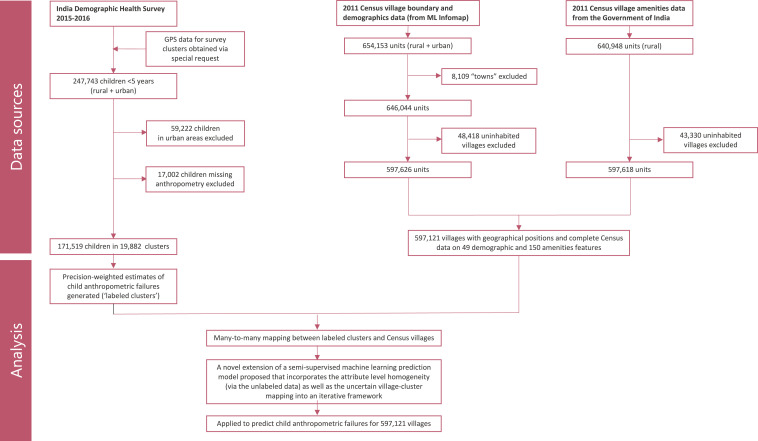
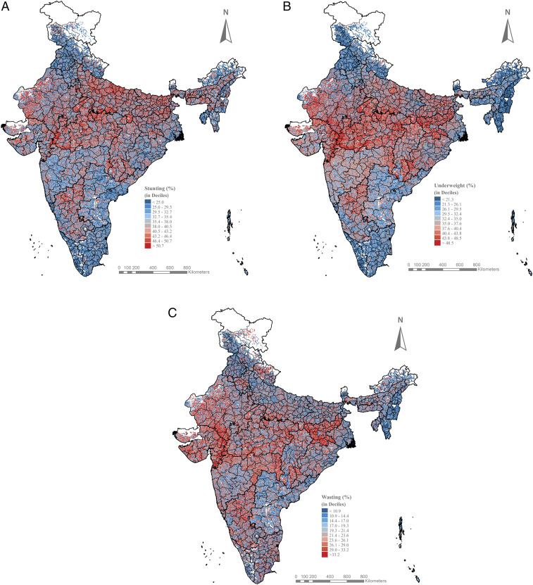
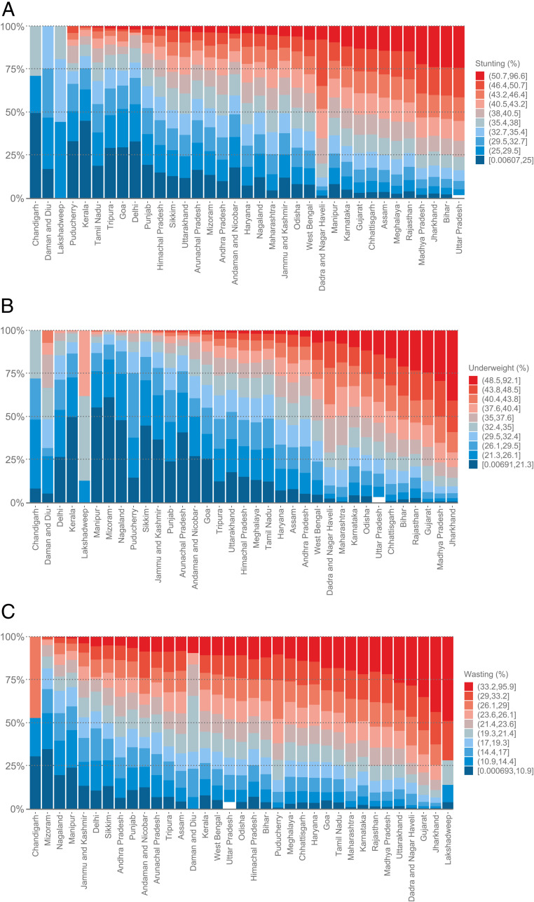
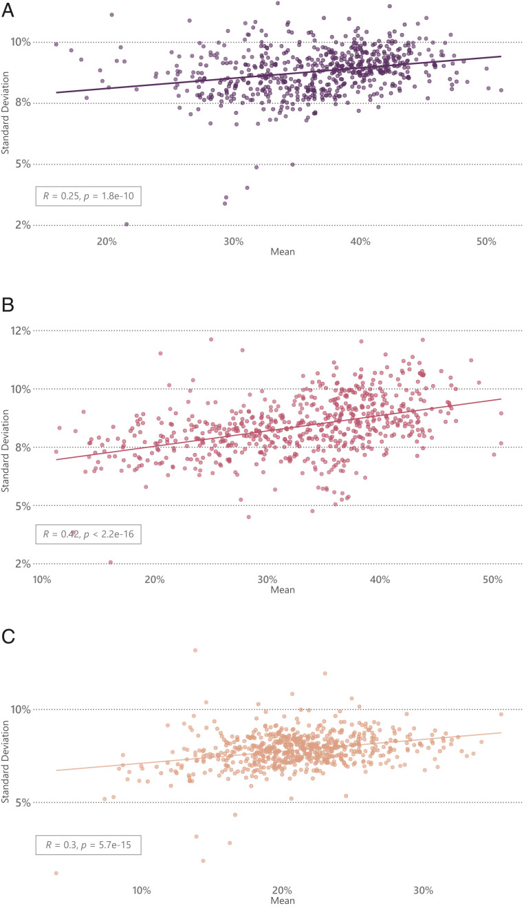
There are emerging opportunities to assess health indicators at truly small areas with increasing availability of data geocoded to micro geographic units and advanced modeling techniques. The utility of such fine-grained data can be fully leveraged if linked to local governance units that are accountable for implementation of programs and interventions. We used data from the 2011 Indian Census for village-level demographic and amenities features and the 2016 Indian Demographic and Health Survey in a bias-corrected semisupervised regression framework to predict child anthropometric failures for all villages in India. Of the total geographic variation in predicted child anthropometric failure estimates, 54.2 to 72.3% were attributed to the village level followed by 20.6 to 39.5% to the state level. The mean predicted stunting was 37.9% (SD: 10.1%; IQR: 31.2 to 44.7%), and substantial variation was found across villages ranging from less than 5% for 691 villages to over 70% in 453 villages. Estimates at the village level can potentially shift the paradigm of policy discussion in India by enabling more informed prioritization and precise targeting. The proposed methodology can be adapted and applied to diverse population health indicators, and in other contexts, to reveal spatial heterogeneity at a finer geographic scale and identify local areas with the greatest needs and with direct implications for actions to take place.
Keywords: India; child undernutrition; local governance; mapping; precision public policy.
Copyright © 2021 the Author(s). Published by PNAS.
Conflict of interest statement
The authors declare no competing interest.
Figures
Similar articles
-
Estimating the Burden of Child Undernutrition for Smaller Electoral Units in India.JAMA Netw Open. 2021 Oct 1;4(10):e2129416. doi: 10.1001/jamanetworkopen.2021.29416. JAMA Netw Open. 2021. PMID: 34714345 Free PMC article.
-
Small area variation in child undernutrition across 640 districts and 543 parliamentary constituencies in India.Sci Rep. 2021 Feb 25;11(1):4558. doi: 10.1038/s41598-021-83992-6. Sci Rep. 2021. PMID: 33633215 Free PMC article.
-
Spatial modeling of child malnutrition attributable to drought in India.Int J Public Health. 2020 Apr;65(3):281-290. doi: 10.1007/s00038-020-01353-y. Epub 2020 Apr 2. Int J Public Health. 2020. PMID: 32240317
-
Prevalence of malnutrition in human immunodeficiency virus/acquired immunodeficiency syndrome orphans in the Nyanza province of Kenya: a comparison of conventional indexes with a composite index of anthropometric failure.J Am Diet Assoc. 2008 Jun;108(6):1014-7. doi: 10.1016/j.jada.2008.03.008. J Am Diet Assoc. 2008. PMID: 18502236
-
Prevalence of malnutrition in rural Karnataka, South India: a comparison of anthropometric indicators.J Health Popul Nutr. 2002 Sep;20(3):239-44. J Health Popul Nutr. 2002. PMID: 12430761
Cited by
-
An environmental justice analysis of air pollution in India.Sci Rep. 2023 Oct 4;13(1):16690. doi: 10.1038/s41598-023-43628-3. Sci Rep. 2023. PMID: 37794063 Free PMC article.
-
Geospatial analysis enables combined poultry-fish farm monitoring in the fragile state of Myanmar.Nat Food. 2025 Jul;6(7):664-667. doi: 10.1038/s43016-025-01192-1. Epub 2025 Jul 23. Nat Food. 2025. PMID: 40702332
-
Progress on Sustainable Development Goal indicators in 707 districts of India: a quantitative mid-line assessment using the National Family Health Surveys, 2016 and 2021.Lancet Reg Health Southeast Asia. 2023 Feb 21;13:100155. doi: 10.1016/j.lansea.2023.100155. eCollection 2023 Jun. Lancet Reg Health Southeast Asia. 2023. PMID: 37383562 Free PMC article.
-
Estimating the Burden of Child Undernutrition for Smaller Electoral Units in India.JAMA Netw Open. 2021 Oct 1;4(10):e2129416. doi: 10.1001/jamanetworkopen.2021.29416. JAMA Netw Open. 2021. PMID: 34714345 Free PMC article.
-
The Efficiency of Anganwadi Centers Located in Rural Field Practice Area of a Medical College in North India: Data Envelopment Analysis.Indian J Community Med. 2022 Oct-Dec;47(4):562-566. doi: 10.4103/ijcm.ijcm_388_22. Epub 2022 Dec 14. Indian J Community Med. 2022. PMID: 36742964 Free PMC article.
References
-
- IHME , The Global Burden of Disease: Generating Evidence, Guiding Policy (IHME Seattle, WA, 2013).
-
- Annan K., Data can help to end malnutrition across Africa. Nature 555, 7 (2018). - PubMed
-
- Dowell S. F., Blazes D., Desmond-Hellmann S., Four steps to precision public health. Nat. News 540, 189 (2016).
Publication types
MeSH terms
LinkOut - more resources
Full Text Sources
Medical
