

Internet of Things Geosensor Network for Cost-Effective Landslide Early Warning Systems
- PMID: 33917752
- PMCID: PMC8068166
- DOI: 10.3390/s21082609
Internet of Things Geosensor Network for Cost-Effective Landslide Early Warning Systems
Abstract
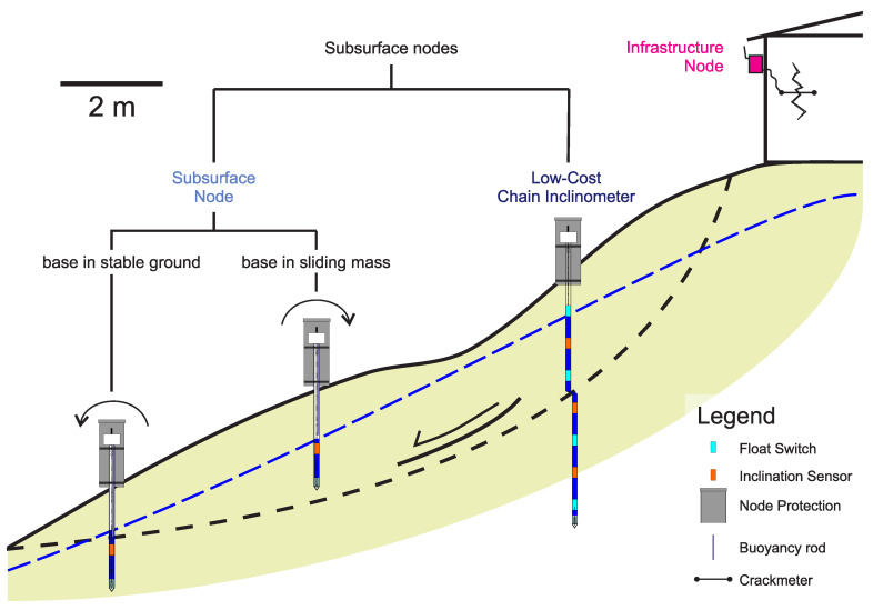
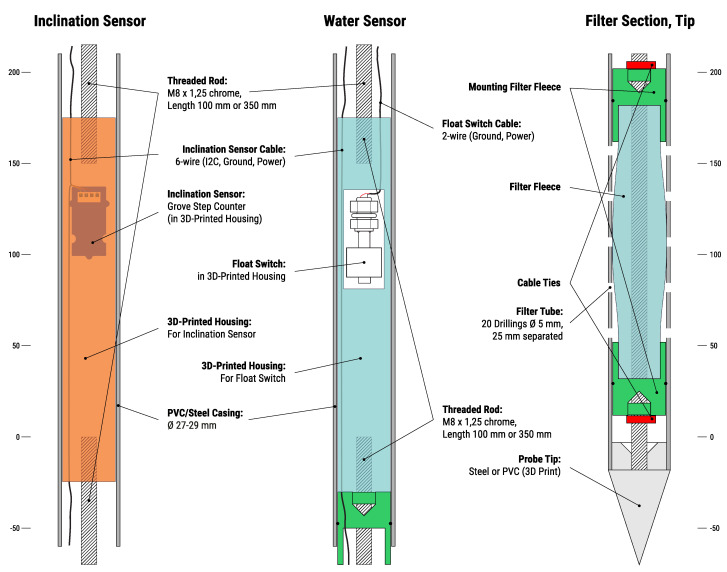
Worldwide, cities with mountainous areas struggle with an increasing landslide risk as a consequence of global warming and population growth, especially in low-income informal settlements. Landslide Early Warning Systems (LEWS) are an effective measure to quickly reduce these risks until long-term risk mitigation measures can be realized. To date however, LEWS have only rarely been implemented in informal settlements due to their high costs and complex operation. Based on modern Internet of Things (IoT) technologies such as micro-electro-mechanical systems (MEMS) sensors and the LoRa (Long Range) communication protocol, the Inform@Risk research project is developing a cost-effective geosensor network specifically designed for use in a LEWS for informal settlements. It is currently being implemented in an informal settlement in the outskirts of Medellin, Colombia for the first time. The system, whose hardware and firmware is open source and can be replicated freely, consists of versatile LoRa sensor nodes which have a set of MEMS sensors (e.g., tilt sensor) on board and can be connected to various different sensors including a newly developed low cost subsurface sensor probe for the detection of ground movements and groundwater level measurements. Complemented with further innovative measurement systems such as the Continuous Shear Monitor (CSM) and a flexible data management and analysis system, the newly developed LEWS offers a good benefit-cost ratio and in the future can hopefully find application in other parts of the world.
Keywords: Colombian Andes; IoT; early warning system; geosensors; informal settlements; landslides; low income settlements; monitoring.
Conflict of interest statement
The authors declare no conflict of interest. The funders had no role in the design of the study, in the collection, analyses, or interpretation of data, in the writing of the manuscript, or in the decision to publish the results.
Figures


References
-
- Smith H., Garcia-Ferrari S., Medero G., Rivera H., Caballero H., Castro W., Abiko A., Marinho F., Ferreira K. Learning from Co-Produced Landslide Risk Mitigation Strategies in Low-Income Settlements in Medellín (Colombia) and São Paulo (Brazil) Department of International Urbanism, University of Stuttgart; Stuttgart, Germany: 2018. N-AERUS XIX.
-
- Rengers F.K., McGuire L.A., Oakley N.S., Kean J.W., Staley D.M., Tang H. Landslides after wildfire: Initiation, magnitude, and mobility. Landslides. 2020;17:2631–2641. doi: 10.1007/s10346-020-01506-3. - DOI
-
- Petley D.N. On the impact of urban landslides. Geol. Soc. Lond. Eng. Geol. Spec. Publ. 2009;22:83–99. doi: 10.1144/EGSP22.6. - DOI
-
- Samaddar S., Tatano H. Where do Individuals Seek Opinions for Evacuation? A Case Study from Landslide-prone Slum Communities in Mumbai. J. Nat. Disaster Sci. 2015;36:13–24. doi: 10.2328/jnds.36.13. - DOI
-
- Alexander D. Urban landslides. Prog. Phys. Geogr. Earth Environ. 1989;13:157–189. doi: 10.1177/030913338901300201. - DOI
Grants and funding
LinkOut - more resources
Full Text Sources
Other Literature Sources
