

An Automated Indoor Localization System for Online Bluetooth Signal Strength Modeling Using Visual-Inertial SLAM
- PMID: 33921567
- PMCID: PMC8073482
- DOI: 10.3390/s21082857
An Automated Indoor Localization System for Online Bluetooth Signal Strength Modeling Using Visual-Inertial SLAM
Abstract
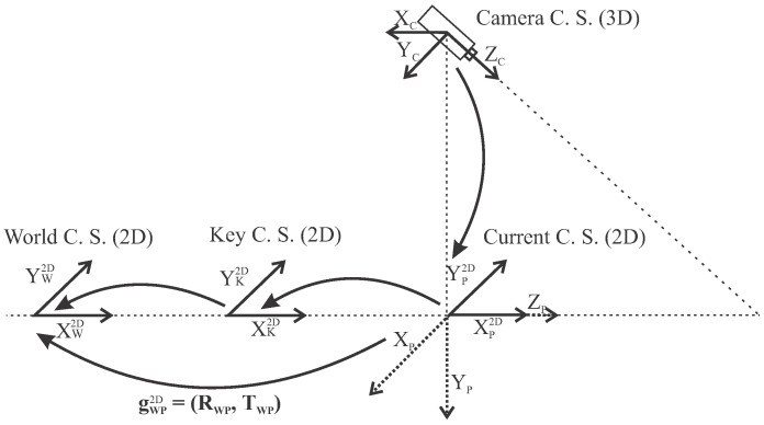
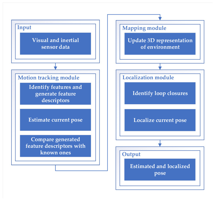
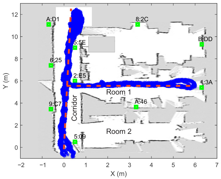
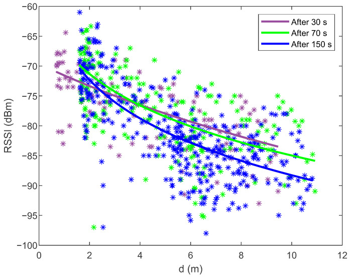
Indoor localization is becoming increasingly important but is not yet widespread because installing the necessary infrastructure is often time-consuming and labor-intensive, which drives up the price. This paper presents an automated indoor localization system that combines all the necessary components to realize low-cost Bluetooth localization with the least data acquisition and network configuration overhead. The proposed system incorporates a sophisticated visual-inertial localization algorithm for a fully automated collection of Bluetooth signal strength data. A suitable collection of measurements can be quickly and easily performed, clearly defining which part of the space is not yet well covered by measurements. The obtained measurements, which can also be collected via the crowdsourcing approach, are used within a constrained nonlinear optimization algorithm. The latter is implemented on a smartphone and allows the online determination of the beacons' locations and the construction of path loss models, which are validated in real-time using the particle swarm localization algorithm. The proposed system represents an advanced innovation as the application user can quickly find out when there are enough data collected for the expected radiolocation accuracy. In this way, radiolocation becomes much less time-consuming and labor-intensive as the configuration time is reduced by more than half. The experiment results show that the proposed system achieves a good trade-off in terms of network setup complexity and localization accuracy. The developed system for automated data acquisition and online modeling on a smartphone has proved to be very useful, as it can significantly simplify and speed up the installation of the Bluetooth network, especially in wide-area facilities.
Keywords: Bluetooth low energy; beacon; constrained optimization; indoor localization; particle swarm optimization; path loss model; visual-inertial SLAM.
Conflict of interest statement
The authors declare no conflict of interest.
Figures
References
-
- Montoliu R., Sansano E., Gascó A., Belmonte O., Caballer A. Indoor Positioning for Monitoring Older Adults at Home: Wi-Fi and BLE Technologies in Real Scenarios. Electronics. 2020;9:728. doi: 10.3390/electronics9050728. - DOI
-
- Dinh T.M.T., Duong N.S., Sandrasegaran K. Smartphone-Based Indoor Positioning Using BLE iBeacon and Reliable Lightweight Fingerprint Map. IEEE Sens. J. 2020;20:10283–10294. doi: 10.1109/JSEN.2020.2989411. - DOI
-
- Ramos J., Costa A., Novais P., Neves J. Interactive Guiding and Localization Platform. Int. J. Artif. Intell. 2014;12:63–78.
-
- Essa E., Abdullah B.A., Wahba A. Improve Performance of Indoor Positioning System using BLE; Proceedings of the 2019 14th International Conference on Computer Engineering and Systems (ICCES); Cairo, Egypt. 17 December 2019; pp. 234–237. - DOI
LinkOut - more resources
Full Text Sources
Other Literature Sources
