

Mangrove sinkholes (cenotes) of the Yucatan Peninsula, a global hotspot of carbon sequestration
- PMID: 33947219
- PMCID: PMC8097219
- DOI: 10.1098/rsbl.2021.0037
Mangrove sinkholes (cenotes) of the Yucatan Peninsula, a global hotspot of carbon sequestration
Abstract
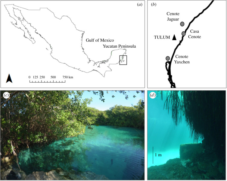
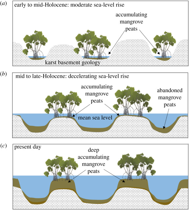
Mangroves are among the most carbon-dense ecosystems on the planet. The capacity of mangroves to store and accumulate carbon has been assessed and reported at regional, national and global scales. However, small-scale sampling is still revealing 'hot spots' of carbon accumulation. This study reports one of these hotspots, with one of the largest-recorded carbon stocks in mangroves associated with sinkholes (cenotes) in the Yucatan Peninsula, Mexico. We assessed soil organic carbon (SOC) stocks, sequestration rates and carbon origin of deep peat soils (1 to 6 m). We found massive amounts of SOC up to 2792 Mg C ha-1, the highest value reported in the literature so far. This SOC is primarily derived from highly preserved mangrove roots and has changed little since its deposition, which started over 3220 years ago (±30 BP). Most cenotes are owned by Mayan communities and are threatened by increased tourism and the resulting extraction and pollution of groundwater. These hot spots of carbon sequestration, albeit small in area, require adequate protection and could provide valuable financial opportunities through carbon-offsetting mechanisms and other payments for ecosystem services.
Keywords: Caribbean; Yucatan; carbon credits; karst; soil organic carbon; wetlands.
Figures
References
-
- Murdiyarso D, et al. 2015. The potential of Indonesian mangrove forests for global climate change mitigation. Nat. Clim. Chang. 5, 1089–1092. ( 10.1038/nclimate2734) - DOI
-
- Hamilton SE, Friess DA. 2018. Global carbon stocks and potential emissions due to mangrove deforestation from 2000 to 2012. Nat. Clim. Chang. 8, 240–244 ( 10.1038/s41558-018-0090-4) - DOI
-
- Kauffman J, et al. 2020. Total ecosystem carbon stocks of mangroves across broad global environmental and physical gradients. Ecol. Monogr. 90, e01405. ( 10.1002/ecm.1405) - DOI
-
- Perry E, Velazquez-Oliman G, Marin L. 2002. The hydrogeochemistry of the karst aquifer system of the northern Yucatan Peninsula, Mexico. Int. Geol. Rev. 44, 191–221. ( 10.2747/0020-6814.44.3.191) - DOI
Publication types
MeSH terms
Substances
Associated data
LinkOut - more resources
Full Text Sources
Research Materials