

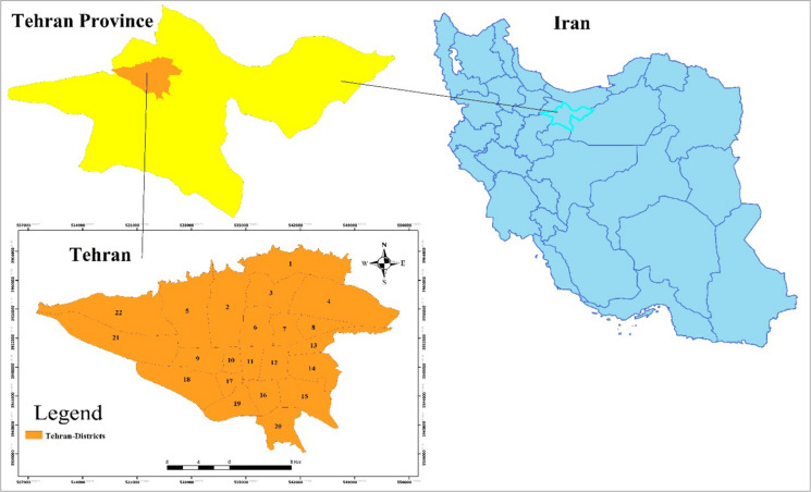
Spatio-temporal analysis of COVID-19 incidence rate using GIS: a case study-Tehran metropolitan, Iran
- PMID: 33994652
- PMCID: PMC8114020
- DOI: 10.1007/s10708-021-10438-x
Spatio-temporal analysis of COVID-19 incidence rate using GIS: a case study-Tehran metropolitan, Iran
Abstract
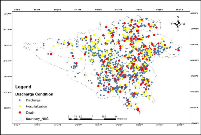
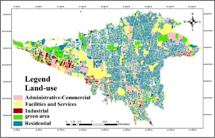
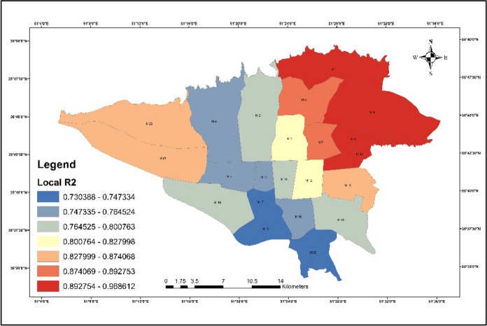
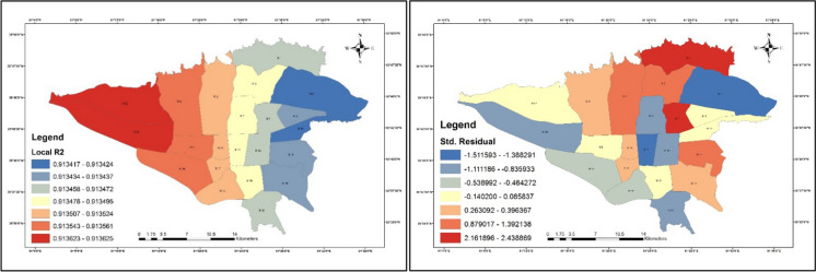
COVID-19 has been distinguished as a zoonotic coronavirus, like SARS coronavirus and MERS coronavirus. Tehran metropolis, as the capital of Iran, has a high density of residents that experienced a high incidence and mortality rates which daily increase the number of death and cases. In this study, the IDW (Inverse Distance Weight), Hotspots, and GWR (Geography Weighted Regression) Model are used as methods for analyzing big data COVID-19 in Tehran. The results showed that the majority of patients and deaths were men, but the death rate was higher in women than in men; also was observed a direct relationship between the area of the houses, and the infected rate, to COVID-19. Also, the results showed a disproportionate distribution of patients in Tehran, although in the eastern regions the number of infected people is higher than in other districts; the eastern areas have a high population density as well as residential land use, and there is a high relationship between population density in residential districts and administrative-commercial and the number of COVID-19 cases in all regions. The outputs of local R2 were interesting among patients and underlying disorders; the local R2 between hypertension and neurological diseases was 0.91 and 0.79, respectively, which was higher than other disorders. The highest rates of local R2 for diabetes and heart disease were 0.67 and 0.55, respectively. From this study, it can be concluded the restrictions must be considered especially, in areas densely populated for all people.
Keywords: COVID-19; Chronic diseases; GWR model; Land-use; Tehran.
© The Author(s), under exclusive licence to Springer Nature B.V. 2021.
Figures


Similar articles
-
A description of spatial-temporal patterns of the novel COVID-19 outbreak in the neighbourhoods' scale in Tehran, Iran.Med J Islam Repub Iran. 2021 Oct 4;35:128. doi: 10.47176/mjiri.35.128. eCollection 2021. Med J Islam Repub Iran. 2021. PMID: 35321381 Free PMC article.
-
Spatial analysis of driving accidents leading to deaths related to motorcyclists in Tehran.Chin J Traumatol. 2019 Jun;22(3):148-154. doi: 10.1016/j.cjtee.2018.12.006. Epub 2019 Apr 6. Chin J Traumatol. 2019. PMID: 31056469 Free PMC article.
-
Spatial and temporal analysis of the COVID-19 incidence pattern in Iran.Environ Sci Pollut Res Int. 2021 Mar;28(11):13605-13615. doi: 10.1007/s11356-020-11499-0. Epub 2020 Nov 14. Environ Sci Pollut Res Int. 2021. PMID: 33188632 Free PMC article.
-
Association between COVID-19 Mortality and Underlying Disease; Tehran, Iran.J Caring Sci. 2024 Jun 2;14(1):37-41. doi: 10.34172/jcs.025.33254. eCollection 2025 Feb. J Caring Sci. 2024. PMID: 40391312 Free PMC article. Review.
-
Global data analysis and risk factors associated with morbidity and mortality of COVID-19.Gene Rep. 2022 Mar;26:101505. doi: 10.1016/j.genrep.2022.101505. Epub 2022 Jan 15. Gene Rep. 2022. PMID: 35071820 Free PMC article. Review.
Cited by
-
Methods Used in the Spatial and Spatiotemporal Analysis of COVID-19 Epidemiology: A Systematic Review.Int J Environ Res Public Health. 2022 Jul 6;19(14):8267. doi: 10.3390/ijerph19148267. Int J Environ Res Public Health. 2022. PMID: 35886114 Free PMC article.
-
Assessing eco-geographic influences on COVID-19 transmission: a global analysis.Sci Rep. 2024 May 22;14(1):11728. doi: 10.1038/s41598-024-62300-y. Sci Rep. 2024. PMID: 38777817 Free PMC article.
-
Potential physical distance in the open urban grey space of city counties in Poland and COVID-19 cases and deaths throughout the pandemic.Arch Public Health. 2025 Mar 25;83(1):80. doi: 10.1186/s13690-025-01563-x. Arch Public Health. 2025. PMID: 40133965 Free PMC article.
-
Conditioning factors in the spreading of Covid-19 - Does geography matter?Heliyon. 2024 Feb 3;10(3):e25810. doi: 10.1016/j.heliyon.2024.e25810. eCollection 2024 Feb 15. Heliyon. 2024. PMID: 38356610 Free PMC article. Review.
-
Modelling Impact of High-Rise, High-Density Built Environment on COVID-19 Risks: Empirical Results from a Case Study of Two Chinese Cities.Int J Environ Res Public Health. 2023 Jan 12;20(2):1422. doi: 10.3390/ijerph20021422. Int J Environ Res Public Health. 2023. PMID: 36674175 Free PMC article.
References
-
- Ahmadi M, Baaghide M, Roudbari AD, Asadi M. Modeling the role of topography on the potential of tourism climate in Iran. Modeling Earth Systems and Environment. 2018;4(1):13–25. doi: 10.1007/s40808-018-0423-3. - DOI
-
- Ahmadi M, Kashki A, Roudbari AD. Spatial modeling of seasonal precipitation elevation in Iran based on aphrodite database. Modeling Earth Systems and Environment. 2018;4(2):619–633. doi: 10.1007/s40808-018-0444-y. - DOI
-
- Alibakhshi Z, Ahmadi M, Asl MF. Modeling biophysical variables and land surface temperature using the GWR model: case study—Tehran and its satellite cities. Journal of the Indian Society of Remote Sensing. 2020;48(1):59–70. doi: 10.1007/s12524-019-01062-x. - DOI
LinkOut - more resources
Full Text Sources
Other Literature Sources
Miscellaneous